Rubha Nead a' Gheòidh

Coastal Feature, Headland, Point in Argyllshire

Scotland

Rubha Nead a' Gheòidh

Creachasdal Beag A skerry off the east end of Tiree.
Creachasdal Beag Credit: Richard Webb

Rubha Nead a' Gheòidh is a prominent coastal feature located in Argyllshire, Scotland. It is a headland that extends into the Atlantic Ocean, forming a distinctive point along the rugged coastline. The name Rubha Nead a' Gheòidh translates to "Eagle's Nest Point," reflecting the area's natural beauty and wildlife.

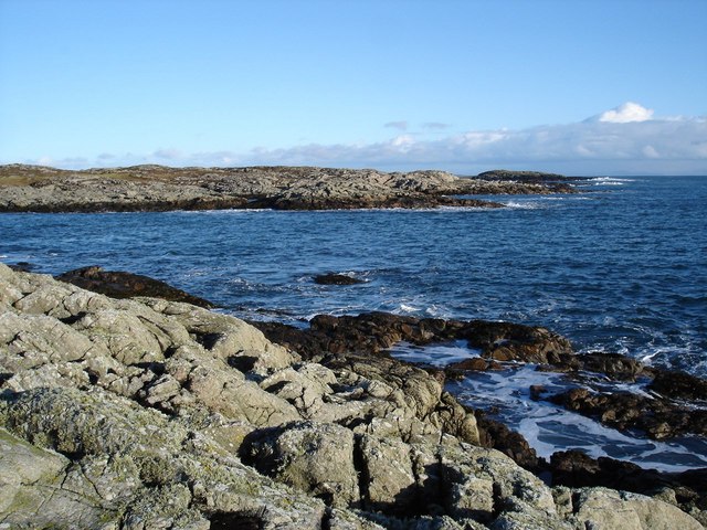
The headland is characterized by steep cliffs, which provide breathtaking views of the surrounding landscape. The cliffs are composed of ancient rocks, displaying a variety of geological formations, including layers of sedimentary rocks and occasional fossilized remains. These geological features make Rubha Nead a' Gheòidh an attractive destination for geologists and nature enthusiasts alike.

The headland is also home to a diverse range of flora and fauna. The surrounding area is covered in heather, grasses, and wildflowers, creating a colorful and vibrant landscape. Seabirds, such as gannets, puffins, and guillemots, can be observed nesting on the cliffs. The headland's location and isolation make it an ideal habitat for these seabird colonies.

Visitors to Rubha Nead a' Gheòidh can explore the area through coastal walks and hiking trails that offer stunning panoramic views of the Atlantic Ocean. The headland's dramatic cliffs also attract climbers seeking challenging routes along the vertical rock faces.

Overall, Rubha Nead a' Gheòidh is a captivating coastal feature in Argyllshire, offering a unique blend of geological wonders, diverse wildlife, and breathtaking views, making it a must-visit destination for nature enthusiasts and outdoor adventurers alike.

If you have any feedback on the listing, please let us know in the comments section below.

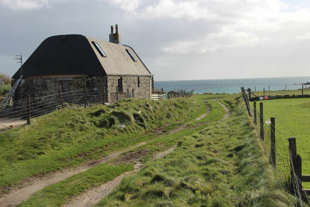
Rubha Nead a' Gheòidh Images

Images are sourced within 2km of 56.526231/-6.7299966 or Grid Reference NM0947. Thanks to Geograph Open Source API. All images are credited.

Creachasdal Beag A skerry off the east end of Tiree.
Creachasdal Beag
A skerry off the east end of Tiree.
Machair near Caolas During a long dry spell. The rains returned soon after this was taken and the Tiree Festival abandoned due to bad weather.
Machair near Caolas
During a long dry spell. The rains returned soon after this was taken and the Tiree Festival abandoned due to bad weather.
Road, Caolas
Road, Caolas
A refurbished house at Ruaig
Wind turbine at Caolas
Croft buildings, northeast Tiree
Coastal pasture at Rosgill
Sea inlet at Cnoc na Bothaig
Restored Tiree 'spotted' house
Milton Small fishing port at Milton
Milton
Small fishing port at Milton
Skerries off Rubha Nead a' Gheòidh This square has a host of skerries, and a lot of sea.
Skerries off Rubha Nead a' Gheòidh
This square has a host of skerries, and a lot of sea.
Librig Bheag and Librig Mhòr Librig Bheag is on the left.  Mull in the distance.
Librig Bheag and Librig Mhòr
Librig Bheag is on the left. Mull in the distance.
Skerry formed channel A rather unusual channel formed by a stretch of skerries lying close in to the coast.  Couldn't work out whether the tide emptied out the water.
Skerry formed channel
A rather unusual channel formed by a stretch of skerries lying close in to the coast. Couldn't work out whether the tide emptied out the water.
Creag Sgreuchaidh Looking out through the gap between Tiree and Gunna.
Creag Sgreuchaidh
Looking out through the gap between Tiree and Gunna.
Standing stone near Caolas A somewhat leaning standing stone.
Standing stone near Caolas
A somewhat leaning standing stone.
Triangulation pillar on Dùn Mòr a' Chaolais
Dùn Mòr a' Chaolais (Broch) The remains of the broch wall to be seen left and right of the broch.  The stones for the dyke were probably taken from the broch.
Dùn Mòr a' Chaolais (Broch)
The remains of the broch wall to be seen left and right of the broch. The stones for the dyke were probably taken from the broch.
Looking down on Milton from Dùn Mòr a' Chaolais
Show me another place!

Rubha Nead a' Gheòidh is located at Grid Ref: NM0947 (Lat: 56.526231, Lng: -6.7299966)

Unitary Authority: Argyll and Bute

Police Authority: Argyll and West Dunbartonshire

What 3 Words

///forgot.eyepieces.painting. Near Scarinish, Argyll & Bute

Related Wikis

Gunna, Scotland

Gunna (Gaelic: Gunnaigh) is an island in the Inner Hebrides of Scotland. == Geography and geology == Gunna lies between Coll and Tiree, closer to Coll...

Dun Mor Vaul

Dun Mor Vaul (or simply Dun Mor; Scottish Gaelic: Dùn Mòr) is an iron-age broch located on the north coast of the island of Tiree, in Scotland. ��2�...

Tiree

Tiree (; Scottish Gaelic: Tiriodh, pronounced [ˈtʲʰiɾʲəɣ]) is the most westerly island in the Inner Hebrides of Scotland. The low-lying island, southwest...

Scarinish

Scarinish (Scottish Gaelic: Sgairinis [ˈs̪kaɾʲɪnɪʃ]) is the main village on the island of Tiree, in the Inner Hebrides of Scotland. It is located on the...

Nearby Amenities

Located within 500m of 56.526231,-6.7299966
Source: PGS
Lat/Long: 56.5244372/-6.7355846
Source: PGS
Lat/Long: 56.5246603/-6.7357094
Source: PGS
Lat/Long: 56.5246974/-6.735677
Source: PGS
Lat/Long: 56.5247084/-6.7355597
Source: PGS
Lat/Long: 56.5247071/-6.7353051
Source: PGS
Lat/Long: 56.5244909/-6.7351528
Source: PGS
Lat/Long: 56.5245501/-6.73533
Source: PGS
Lat/Long: 56.5243601/-6.7355023
Source: PGS
Lat/Long: 56.5243643/-6.7351903
Source: PGS
Lat/Long: 56.5243326/-6.7351928
Source: PGS
Lat/Long: 56.5221047/-6.7297437
Source: PGS
Lat/Long: 56.5220193/-6.7302804
Source: PGS
Lat/Long: 56.521967/-6.73048
Source: PGS
Lat/Long: 56.5220069/-6.7304201
Source: PGS
Lat/Long: 56.5220537/-6.730193
Source: PGS
Lat/Long: 56.5221542/-6.7299135
Source: PGS
Lat/Long: 56.522168/-6.7298361
Source: PGS
Lat/Long: 56.527072/-6.7267677
Power: pole
Lat/Long: 56.5268053/-6.7324395
Power: pole
Lat/Long: 56.5277754/-6.7331553
Power: pole
Lat/Long: 56.5282786/-6.7335228
Power: pole
Lat/Long: 56.5283787/-6.7343864
Power: pole
Lat/Long: 56.5285138/-6.7356513
Power: pole
Lat/Long: 56.527327/-6.7350917
Power: pole
Lat/Long: 56.5276497/-6.7357168
Power: pole
Lat/Long: 56.5278476/-6.7361222
Power: pole
Lat/Long: 56.5280445/-6.7368909
The data included in this document is from www.openstreetmap.org. The data is made available under ODbL.

Have you been to Rubha Nead a' Gheòidh?

Leave your review of Rubha Nead a' Gheòidh below (or comments, questions and feedback).