Benges Cove

Sea, Estuary, Creek in Cornwall

England

Benges Cove

Porthcothan Beach
Porthcothan Beach Credit: Roy Hughes

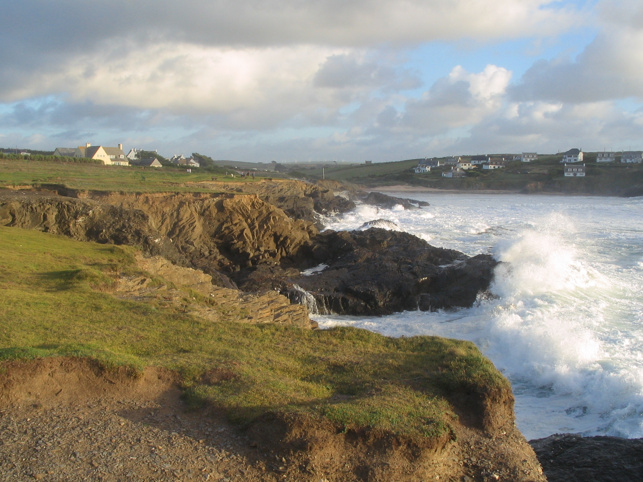
Benges Cove is a picturesque coastal area located in Cornwall, England. Nestled between the charming towns of Fowey and Polruan, it offers visitors a stunning blend of sea, estuary, and creek scenery.

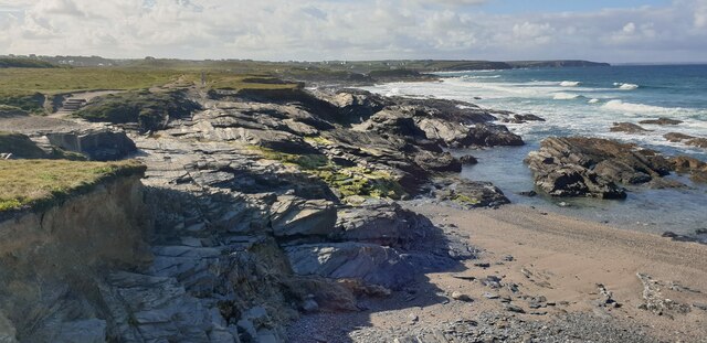
The cove is situated at the mouth of the Fowey River, where it meets the English Channel. This strategic positioning allows for the convergence of freshwater and saltwater, resulting in a unique ecosystem that supports a diverse array of marine life. The intertidal zone is particularly rich, with numerous rock pools teeming with sea anemones, crabs, and small fish.

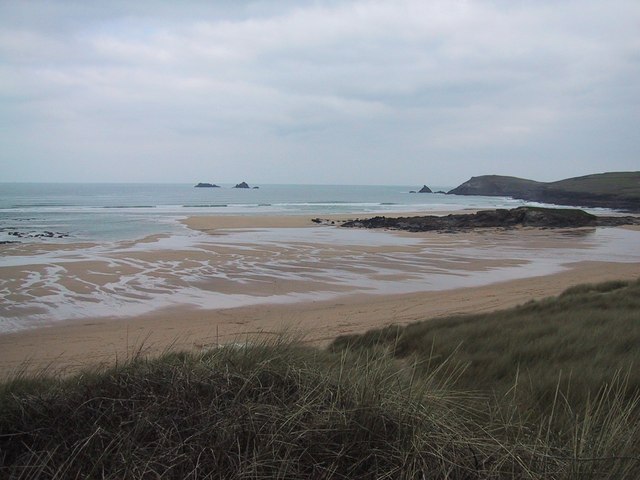
The waters of Benges Cove are crystal clear, making it a popular spot for swimming, snorkeling, and kayaking. The cove's gentle waves and sheltered conditions also make it ideal for boating and sailing enthusiasts. The estuary and creek provide tranquil settings for leisurely walks, birdwatching, and picnicking.

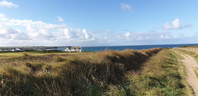
Surrounded by lush green hills, Benges Cove boasts breathtaking panoramic views of the coastline. The coastal path that runs along the cove offers an ideal vantage point for admiring the stunning cliffs and dramatic headlands that characterize the area.

The cove is easily accessible, with a small car park and a nearby ferry service connecting it to Fowey and Polruan. There are also a few quaint cottages and bed and breakfast accommodations available for those wishing to stay overnight and fully immerse themselves in the tranquility and beauty of Benges Cove.

Overall, Benges Cove is a hidden gem in Cornwall, offering a peaceful retreat with its stunning sea, estuary, and creek landscapes, making it a must-visit destination for nature lovers and those seeking a break from the hustle and bustle of daily life.

If you have any feedback on the listing, please let us know in the comments section below.

Benges Cove Images

Images are sourced within 2km of 50.525988/-5.0256569 or Grid Reference SW8573. Thanks to Geograph Open Source API. All images are credited.

Porthcothan Beach
Porthcothan Beach
Atlantic Coaster bus near Trehemborne
St Merryn village sign on the B3276 northbound
St Constantine's Well
St Constantine well
St Constantine well
Chapel Kerketh
Chapel Kerketh
Walk Towards Booby's Bay A view from the path from the car park down to Booby's Bay.
Walk Towards Booby's Bay
A view from the path from the car park down to Booby's Bay.
Fields at Booby's Bay The fields to the north of the path down to Booby's Bay from the car park. You can just see a glimpse of the sea on the horizon.
Fields at Booby's Bay
The fields to the north of the path down to Booby's Bay from the car park. You can just see a glimpse of the sea on the horizon.
The Sea at Booby's Bay Looking down from the cliff at the sea breaking on rocks at Booby's Bay.
The Sea at Booby's Bay
Looking down from the cliff at the sea breaking on rocks at Booby's Bay.
High Tide at Booby's Bay Looking across Booby's Bay towards Constantine Bay and Treyarnon.
High Tide at Booby's Bay
Looking across Booby's Bay towards Constantine Bay and Treyarnon.
Cliff Path at Booby's Bay A cliff top path at Booby's Bay, looking out over the breaking waves.
Cliff Path at Booby's Bay
A cliff top path at Booby's Bay, looking out over the breaking waves.
Rocks at Booby's Bay The sea breaking on rocks at Booby's Bay.
Rocks at Booby's Bay
The sea breaking on rocks at Booby's Bay.
Gentle Cliffs at Booby's Bay The sea breaking on the cliffs and rocks at Booby's Bay.
Gentle Cliffs at Booby's Bay
The sea breaking on the cliffs and rocks at Booby's Bay.
Rocks towards Treyarnon, Booby's Bay Viewed from the very edge of the cliff, the rocks at Booby's Bay, looking towards Treyarnon on the horizon.
Rocks towards Treyarnon, Booby's Bay
Viewed from the very edge of the cliff, the rocks at Booby's Bay, looking towards Treyarnon on the horizon.
Booby's Bay from Cliff Edge Rocks and steep pebble beach at Booby's Bay from the edge of the cliff.
Booby's Bay from Cliff Edge
Rocks and steep pebble beach at Booby's Bay from the edge of the cliff.
Leaving Towan village
Constantine Bay Stores
Leaving Constantine Bay and passing Trevose Golf Club
Show me another place!

Benges Cove is located at Grid Ref: SW8573 (Lat: 50.525988, Lng: -5.0256569)

Unitary Authority: Cornwall

Police Authority: Devon and Cornwall

What 3 Words

///gravel.joints.bombshell. Near Padstow, Cornwall

Related Wikis

Treyarnon

Treyarnon (Cornish: Tre Arnen, meaning Garnen's farm) is a hamlet west of St Merryn in Cornwall, England, UK near Padstow. Treyarnon Beach is a small beach...

Constantine Bay

Constantine Bay (Cornish: Eglos Costentin, meaning church of St Constantine) is a village and beach on the Atlantic coast of north Cornwall, England, United...

Trevose Golf & Country Club

Trevose Golf & Country Club is a 27-hole golf club in Cornwall, England which has hosted many of the leading amateur golf tournaments in Britain, including...

Booby's Bay

Booby's Bay is a sandy beach near Padstow, Cornwall, England, UK. During World War I, the three masted sailing ship Carl of the German navy was beached...

Nearby Amenities

Located within 500m of 50.525988,-5.0256569
Source: PGS
Lat/Long: 50.5285044/-5.0272046
Source: PGS
Lat/Long: 50.5281863/-5.0257015
Source: PGS
Lat/Long: 50.5278087/-5.0251742
Source: PGS
Lat/Long: 50.527483/-5.0249837
Source: PGS
Lat/Long: 50.5271216/-5.0247371
Source: PGS
Lat/Long: 50.5272758/-5.0234496
Source: PGS
Lat/Long: 50.5268078/-5.0231934
Source: PGS
Lat/Long: 50.5267336/-5.0230499
Created By: almien_coastlines
Source: PGS
Lat/Long: 50.5253258/-5.0237898
Source: PGS
Lat/Long: 50.5256841/-5.0249489
Source: PGS
Lat/Long: 50.5258052/-5.0252305
Source: PGS
Lat/Long: 50.5262076/-5.0259923
Source: PGS
Lat/Long: 50.5262588/-5.0262095
Source: PGS
Lat/Long: 50.526001/-5.0266975
Source: PGS
Lat/Long: 50.5258053/-5.0269222
Source: PGS
Lat/Long: 50.5253916/-5.0277069
Source: PGS
Lat/Long: 50.5239946/-5.0287761
Source: PGS
Lat/Long: 50.5235171/-5.0268449
Source: PGS
Lat/Long: 50.5231897/-5.0271346
Ford: yes
Lat/Long: 50.5255016/-5.0226203
Barrier: stile
Material: stone
Step Count: 2
Stile: stepover
Lat/Long: 50.5301999/-5.0247017
Gary's Beach Shop
Shop: convenience
Lat/Long: 50.5265191/-5.0220656
Toilets
Check Date: 2021-10-04
Fee: no
Wheelchair: yes
Lat/Long: 50.5269283/-5.0226825
Source: PGS
Lat/Long: 50.5253435/-5.0278092
Turning Circle
Lat/Long: 50.5287889/-5.0213582
Warren Cove
Image: https://archive.org/details/pxl-20210917-124338157/PXL_20210917_112219431.jpg
Place: locality
Lat/Long: 50.5221943/-5.0273632
Trethias Island
Place: locality
Lat/Long: 50.5259084/-5.0276087
Noexit: yes
Lat/Long: 50.5252346/-5.0189515
Bench
Backrest: yes
Lat/Long: 50.5283714/-5.0246237
Bench
Backrest: yes
Lat/Long: 50.52514/-5.0249168
Bench
Backrest: yes
Image: https://archive.org/details/pxl-20210917-124338157/PXL_20210917_113756724.jpg
Inscription: Charlie's Bench
Openbenches Id: 3669
Lat/Long: 50.5257394/-5.0266776
Bench
Backrest: yes
Lat/Long: 50.5233581/-5.0264912
Rock Pool - Treyarnon
Leisure: swimming_area
Lat/Long: 50.5279886/-5.0250242
Bench
Backrest: yes
Survey Date: 2023-02-12
Lat/Long: 50.5295585/-5.0258848
Bench
Backrest: yes
Survey Date: 2023-02-12
Lat/Long: 50.5298054/-5.025379
Bench
Backrest: yes
Survey Date: 2023-02-12
Lat/Long: 50.5295938/-5.0257847
Bench
Backrest: yes
Survey Date: 2023-02-12
Lat/Long: 50.5287108/-5.0248908
Bench
Backrest: yes
Survey Date: 2023-02-12
Lat/Long: 50.528317/-5.024578
Bench
Backrest: no
Survey Date: 2023-02-12
Lat/Long: 50.5281895/-5.0244346
Bicycle Parking
Capacity: 2
Survey Date: 2023-02-12
Lat/Long: 50.5268719/-5.0227121
Life Ring
Emergency: life_ring
Survey Date: 2023-02-12
Lat/Long: 50.5261754/-5.0220084
Covered: no
Leisure: picnic_table
Survey Date: 2023-02-12
Lat/Long: 50.5250806/-5.0233946
Fire Hydrant
Emergency: fire_hydrant
Fire Hydrant Type: underground
Survey Date: 2023-02-12
Lat/Long: 50.5246823/-5.0190187
Bench
Backrest: yes
Survey Date: 2023-02-12
Lat/Long: 50.5303531/-5.02505
Bench
Backrest: yes
Survey Date: 2023-02-12
Lat/Long: 50.5297278/-5.0255919
Bench
Backrest: yes
Survey Date: 2023-02-12
Lat/Long: 50.5293503/-5.0258672
Bench
Backrest: yes
Survey Date: 2023-02-12
Lat/Long: 50.5282275/-5.0244811
Bench
Backrest: yes
Survey Date: 2023-02-12
Lat/Long: 50.5280883/-5.0243484
Bench
Backrest: yes
Survey Date: 2023-02-12
Lat/Long: 50.528024/-5.0242992
Fire Hydrant
Emergency: fire_hydrant
Fire Hydrant Type: underground
Survey Date: 2023-02-12
Lat/Long: 50.5273065/-5.0232348
Bench
Backrest: yes
Survey Date: 2023-02-12
Lat/Long: 50.5271552/-5.0234132
Bicycle Parking
Capacity: 3
Survey Date: 2023-02-12
Lat/Long: 50.5269327/-5.0227924
Life Ring
Emergency: life_ring
Survey Date: 2023-02-12
Lat/Long: 50.525302/-5.0228821
Covered: no
Leisure: picnic_table
Survey Date: 2023-02-12
Lat/Long: 50.5251124/-5.0233723
Bench
Backrest: yes
Image: https://archive.org/details/pxl-20210917-124338157/PXL_20210917_120019630.jpg
Inscription: Ron's Seat 1994
Openbenches Id: 3671
Survey Date: 2023-02-12
Lat/Long: 50.525478/-5.0257494
Bench
Backrest: yes
Survey Date: 2023-02-12
Lat/Long: 50.5240113/-5.0271472
Life Ring
Emergency: life_ring
Survey Date: 2023-02-12
Lat/Long: 50.5273796/-5.0239835
Bench
Backrest: yes
Survey Date: 2023-02-12
Lat/Long: 50.527068/-5.0229179
Bench
Backrest: yes
Survey Date: 2023-02-12
Lat/Long: 50.5261081/-5.0263282
Post Box
Collection Times: Mo-Fr 09:00; Sa 07:00; Su off
Operator: Royal Mail
Operator Wikidata: Q638098
Post Box Mounting: pier
Post Box Type: lamp
Ref: PL28 136D
Royal Cypher: EIIR
Royal Cypher Wikidata: Q33102113
Survey Date: 2023-02-12
Lat/Long: 50.5264245/-5.0219638
Leisure: picnic_table
Survey Date: 2023-02-12
Lat/Long: 50.5299668/-5.0252334
Bench
Backrest: yes
Survey Date: 2023-02-12
Lat/Long: 50.5293883/-5.026059
Bench
Backrest: yes
Survey Date: 2023-02-12
Lat/Long: 50.5279503/-5.0242482
Phone
Emergency: phone
Lat/Long: 50.5264071/-5.0223146
Tidal Pool
Tourism: attraction
Lat/Long: 50.5274428/-5.0245569
Cafe
Lat/Long: 50.5249725/-5.0233918
Image: https://archive.org/details/pxl-20210917-124338157/PXL_20210917_112212231.jpg
Lat/Long: 50.5227817/-5.0268003
Image: https://archive.org/details/pxl-20210917-124338157/PXL_20210917_113704213.jpg
Lat/Long: 50.5256142/-5.0268259
Bench
Backrest: yes
Inscription: In Memory of Nicola Annette Shaw 26/08/77 - 25/08/96 Her favourite place
Openbenches Id: 946
Lat/Long: 50.5257872/-5.0267695
Image: https://archive.org/details/pxl-20210917-124338157/PXL_20210917_112415157.jpg
Lat/Long: 50.523388/-5.0261808
Image: https://archive.org/details/pxl-20210917-124338157/PXL_20210917_115954237.jpg
Lat/Long: 50.5255629/-5.0257174
Noexit: yes
Lat/Long: 50.5252163/-5.0191155
Noexit: yes
Lat/Long: 50.5252387/-5.0195864
The data included in this document is from www.openstreetmap.org. The data is made available under ODbL.

Have you been to Benges Cove?

Leave your review of Benges Cove below (or comments, questions and feedback).