Crow Sound

Sea, Estuary, Creek in Cornwall

England

Crow Sound

Bar Point at a low spring tide Looking across Crow Sound to the western end of St Martin’s, Tean, and St Helen’s.
Bar Point at a low spring tide Credit: David Lally

Crow Sound is a picturesque coastal area located in Cornwall, England, renowned for its stunning sea views, estuary, and creek. Situated on the southern coast of Cornwall, it is nestled between the popular destinations of Falmouth and the Lizard Peninsula.

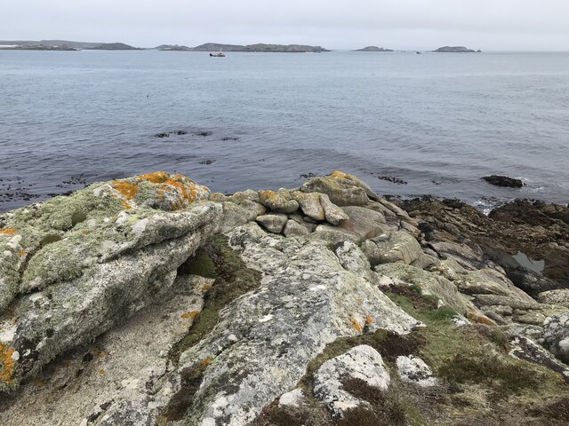
The area is characterized by its crystal-clear turquoise waters, which are a result of the mixing of the Atlantic Ocean and the calmer waters of the Helford River. The sea in Crow Sound offers a range of activities for visitors, including swimming, sailing, and fishing. The water is generally calm, making it an ideal spot for water sports enthusiasts of all levels.

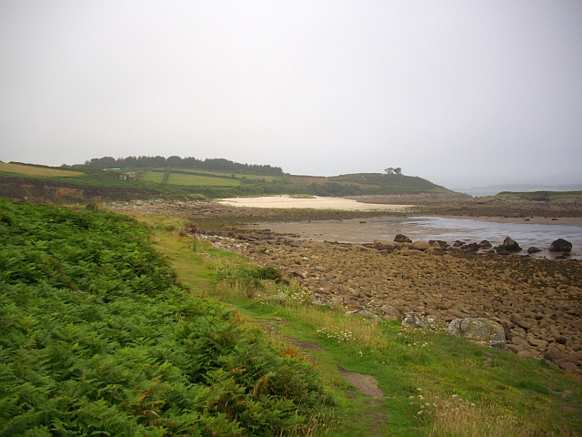
The estuary within Crow Sound is one of its main attractions. It is formed by the convergence of several small rivers, including the Helford River and the Gweek Creek. The estuary is a haven for wildlife, with a rich ecosystem of plants and animals. Visitors can explore the estuary by boat or kayak, taking in the breathtaking scenery and observing the diverse birdlife that calls this area home.

The creek in Crow Sound offers a more peaceful and secluded experience. It winds its way through lush greenery and picturesque villages, providing visitors with a tranquil setting for walking or simply enjoying the natural beauty of the area. The creek is also home to a variety of marine life, such as crabs and fish, which can be spotted during low tide.

Overall, Crow Sound is a hidden gem on the Cornish coast, offering visitors a unique blend of rugged sea views, serene estuaries, and peaceful creeks. Whether you are an outdoor enthusiast or simply seeking a peaceful escape, this area has something to offer for everyone.

If you have any feedback on the listing, please let us know in the comments section below.
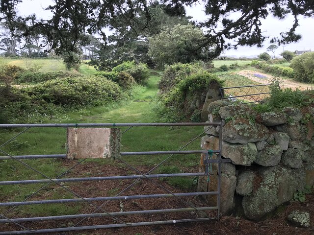
Crow Sound Images

Images are sourced within 2km of 49.938753/-6.2779564 or Grid Reference SV9313. Thanks to Geograph Open Source API. All images are credited.

Bar Point at a low spring tide Looking across Crow Sound to the western end of St Martin’s, Tean, and St Helen’s.
Bar Point at a low spring tide
Looking across Crow Sound to the western end of St Martin’s, Tean, and St Helen’s.
Looking east from Bar Point At a low spring tide.
Looking east from Bar Point
At a low spring tide.
Entrance to the Innisidgen chambered cairn Scheduled Monument including both burial cairn and other features:

Two entrance graves, a prehistoric field system, and Civil War fieldworks and blockhouse on Innisidgen Hill and Helvear Down, St Mary's

List Entry Number:1013271 <span class="nowrap"><a title="https://historicengland.org.uk/listing/the-list/list-entry/1013271?section=official-list-entry" rel="nofollow ugc noopener" href="https://historicengland.org.uk/listing/the-list/list-entry/1013271?section=official-list-entry">Link</a><img style="margin-left:2px;" alt="External link" title="External link - shift click to open in new window" src="https://s1.geograph.org.uk/img/external.png" width="10" height="10"/></span>
Entrance to the Innisidgen chambered cairn
Scheduled Monument including both burial cairn and other features: Two entrance graves, a prehistoric field system, and Civil War fieldworks and blockhouse on Innisidgen Hill and Helvear Down, St Mary's List Entry Number:1013271 LinkExternal link
Rope swing near Innisidgen Hanging from a very high branch of a Monterey Pine.
Rope swing near Innisidgen
Hanging from a very high branch of a Monterey Pine.
Gate with faded sign Possibly an old PRIVATE sign? According to the OS  the track ahead is a right of way..
Gate with faded sign
Possibly an old PRIVATE sign? According to the OS the track ahead is a right of way..
Rocks near Pellew's Redoubt A reprograph of my own first for the square <a title="https://www.geograph.org.uk/photo/815561" href="https://www.geograph.org.uk/photo/815561">Link</a> if only because there’s nothing much else in it! Should get me a T point too!
Rocks near Pellew's Redoubt
A reprograph of my own first for the square Link if only because there’s nothing much else in it! Should get me a T point too!
St Mary's Harbour Pilot Boat in Crow Sound
Crow Sound, Toll's Island A small fishing boat navigates Crow Sound on the eastern side of St Mary's in the Isles of Scilly.  Toll's Island is one of the tidal islands off the Isles of Scilly.  It is located 100 metres east of the coast of St Mary's at Pelistry.  Toll’s Island is linked to St Mary's by a sandy isthmus which is covered at high tide.
Crow Sound, Toll's Island
A small fishing boat navigates Crow Sound on the eastern side of St Mary's in the Isles of Scilly. Toll's Island is one of the tidal islands off the Isles of Scilly. It is located 100 metres east of the coast of St Mary's at Pelistry. Toll’s Island is linked to St Mary's by a sandy isthmus which is covered at high tide.
Isles of Scilly, Eastern Isles from Crow Sound The large island in the background is St Martin's.
Isles of Scilly, Eastern Isles from Crow Sound
The large island in the background is St Martin's.
Hats South Cardinal Marker, Crow Sound A cardinal mark is a sea mark (a buoy or other floating or fixed structure) used in maritime pilotage to indicate the position of a hazard and the direction of safe water. The direction of its two conical top marks indicates the safest side to pass. In this case, both cones are pointing down which indicates that shipping should pass on the south side of the buoy (to avoid the Hats shallows and an uncovering boiler structure from a wreck in the sound. <span class="nowrap"><a title="https://en.wikipedia.org/wiki/Cardinal_mark" rel="nofollow ugc noopener" href="https://en.wikipedia.org/wiki/Cardinal_mark">Link</a><img style="margin-left:2px;" alt="External link" title="External link - shift click to open in new window" src="https://s1.geograph.org.uk/img/external.png" width="10" height="10"/></span>  (Cardinal Mark, Wikipedia).
Hats South Cardinal Marker, Crow Sound
A cardinal mark is a sea mark (a buoy or other floating or fixed structure) used in maritime pilotage to indicate the position of a hazard and the direction of safe water. The direction of its two conical top marks indicates the safest side to pass. In this case, both cones are pointing down which indicates that shipping should pass on the south side of the buoy (to avoid the Hats shallows and an uncovering boiler structure from a wreck in the sound. LinkExternal link (Cardinal Mark, Wikipedia).
Isles of Scilly. Little Ganinick One of the Eastern Isles, a group of twelve small uninhabited islands within the Isles of Scilly Area of Outstanding Natural Beauty. Part of the larger island of Great Ganinick (with more vegetation) can be seen behind (and slightly to the right of) Little Ganinick.
Isles of Scilly. Little Ganinick
One of the Eastern Isles, a group of twelve small uninhabited islands within the Isles of Scilly Area of Outstanding Natural Beauty. Part of the larger island of Great Ganinick (with more vegetation) can be seen behind (and slightly to the right of) Little Ganinick.
Isles of Scilly, Great Arthur Great, Middle and Little Arthur are three of the Eastern Isles, a group of twelve small uninhabited islands within the Isles of Scilly Area of Outstanding Natural Beauty. Great Arthur, as its name suggests, is the largest of the three.
Isles of Scilly, Great Arthur
Great, Middle and Little Arthur are three of the Eastern Isles, a group of twelve small uninhabited islands within the Isles of Scilly Area of Outstanding Natural Beauty. Great Arthur, as its name suggests, is the largest of the three.
Isles of Scilly, Rocky Ledge between Middle and Great Arthur Great, Middle and Little Arthur are three of the Eastern Isles, a group of twelve small uninhabited islands within the Isles of Scilly Area of Outstanding Natural Beauty. Great Arthur, as its name suggests, is the largest of the three.
Isles of Scilly, Rocky Ledge between Middle and Great Arthur
Great, Middle and Little Arthur are three of the Eastern Isles, a group of twelve small uninhabited islands within the Isles of Scilly Area of Outstanding Natural Beauty. Great Arthur, as its name suggests, is the largest of the three.
Isles of Scilly, Middle Arthur Great, Middle and Little Arthur are three of the Eastern Isles, a group of twelve small uninhabited islands within the Isles of Scilly Area of Outstanding Natural Beauty. Great Arthur, as its name suggests, is the largest of the three.
Isles of Scilly, Middle Arthur
Great, Middle and Little Arthur are three of the Eastern Isles, a group of twelve small uninhabited islands within the Isles of Scilly Area of Outstanding Natural Beauty. Great Arthur, as its name suggests, is the largest of the three.
Middle Arthur, Arthur Quay Great, Middle and Little Arthur are three of the Eastern Isles, a group of twelve small uninhabited islands within the Isles of Scilly Area of Outstanding Natural Beauty. Great Arthur, as its name suggests, is the largest of the three.

The three rocky islands are joined by two beaches forming a crescent around Arthur Porth.
Middle Arthur, Arthur Quay
Great, Middle and Little Arthur are three of the Eastern Isles, a group of twelve small uninhabited islands within the Isles of Scilly Area of Outstanding Natural Beauty. Great Arthur, as its name suggests, is the largest of the three. The three rocky islands are joined by two beaches forming a crescent around Arthur Porth.
Rocky Shore, Little Ganilly Little Ganilly (Cornish: Goonhyli Bian, little salt water down) lies just to the north of Little Arthur.
Rocky Shore, Little Ganilly
Little Ganilly (Cornish: Goonhyli Bian, little salt water down) lies just to the north of Little Arthur.
Shags on the Rocks off Great Ganilly The Eastern Isles (Cornish: Enesow Goonhyli) are a group of twelve small uninhabited islands  located to the south–east of St Martin's. The islands lie within the Isles of Scilly Area of Outstanding Natural Beauty, part of the Scilly Heritage Coast and a Site of Special Scientific Interest (SSSI) first designated in 1971 for its flora and fauna (<span class="nowrap"><a title="https://en.wikipedia.org/wiki/Eastern_Isles" rel="nofollow ugc noopener" href="https://en.wikipedia.org/wiki/Eastern_Isles">Link</a><img style="margin-left:2px;" alt="External link" title="External link - shift click to open in new window" src="https://s1.geograph.org.uk/img/external.png" width="10" height="10"/></span> Wikipedia).
Shags on the Rocks off Great Ganilly
The Eastern Isles (Cornish: Enesow Goonhyli) are a group of twelve small uninhabited islands located to the south–east of St Martin's. The islands lie within the Isles of Scilly Area of Outstanding Natural Beauty, part of the Scilly Heritage Coast and a Site of Special Scientific Interest (SSSI) first designated in 1971 for its flora and fauna (LinkExternal link Wikipedia).
Eastern Isles, Ragged Island The Eastern Isles (Cornish: Enesow Goonhyli) are a group of twelve small uninhabited islands  located to the south–east of St Martin's. The islands lie within the Isles of Scilly Area of Outstanding Natural Beauty, part of the Scilly Heritage Coast and a Site of Special Scientific Interest (SSSI) first designated in 1971 for its flora and fauna (<span class="nowrap"><a title="https://en.wikipedia.org/wiki/Eastern_Isles" rel="nofollow ugc noopener" href="https://en.wikipedia.org/wiki/Eastern_Isles">Link</a><img style="margin-left:2px;" alt="External link" title="External link - shift click to open in new window" src="https://s1.geograph.org.uk/img/external.png" width="10" height="10"/></span> Wikipedia).
Eastern Isles, Ragged Island
The Eastern Isles (Cornish: Enesow Goonhyli) are a group of twelve small uninhabited islands located to the south–east of St Martin's. The islands lie within the Isles of Scilly Area of Outstanding Natural Beauty, part of the Scilly Heritage Coast and a Site of Special Scientific Interest (SSSI) first designated in 1971 for its flora and fauna (LinkExternal link Wikipedia).
Show me another place!

Crow Sound is located at Grid Ref: SV9313 (Lat: 49.938753, Lng: -6.2779564)

Division: Isles of Scilly

Unitary Authority: Isles of Scilly

Police Authority: Devon and Cornwall

What 3 Words

///shocked.stub.certainty. Near St Martin's, Isles of Scilly

Related Wikis

Wheel Wreck

The Wheel Wreck is the remains of a shipwreck lying in Crow sound off Little Ganinick in the Isles of Scilly. The wreck site consists of a discrete mound...

Watermill Cove

Watermill Cove is on the north–east coast of St Mary's, Isles of Scilly. It is a historic anchorage, still used today by passing yachts and other small...

Innisidgen

Innisidgen (Cornish: Enys Ojyon, meaning Ox Island) is the site of two Bronze Age entrance graves on the island of St Mary's in the Isles of Scilly. The...

Pelistry

Pelistry (Cornish: Porth Lystry "cove for ships") is a small settlement, situated east of Maypole and north of Normandy, in the east of the island of St...

Nearby Amenities

Located within 500m of 49.938753,-6.2779564
Seamark Type: anchorage
Lat/Long: 49.9358092/-6.2813902
The data included in this document is from www.openstreetmap.org. The data is made available under ODbL.

Have you been to Crow Sound?

Leave your review of Crow Sound below (or comments, questions and feedback).