South Broad Haven

Bay in Aberdeenshire

Scotland

South Broad Haven

Slains Kirk, Collieston
Slains Kirk, Collieston Credit: Bill Harrison

South Broad Haven is a picturesque bay located in Aberdeenshire, Scotland. Nestled along the stunning North Sea coastline, it is known for its natural beauty and tranquil atmosphere. The bay is situated to the north of Aberdeen and is easily accessible by car or public transportation.

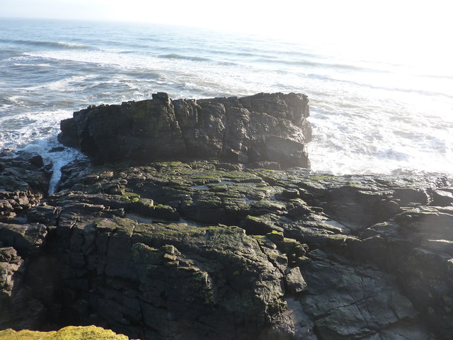
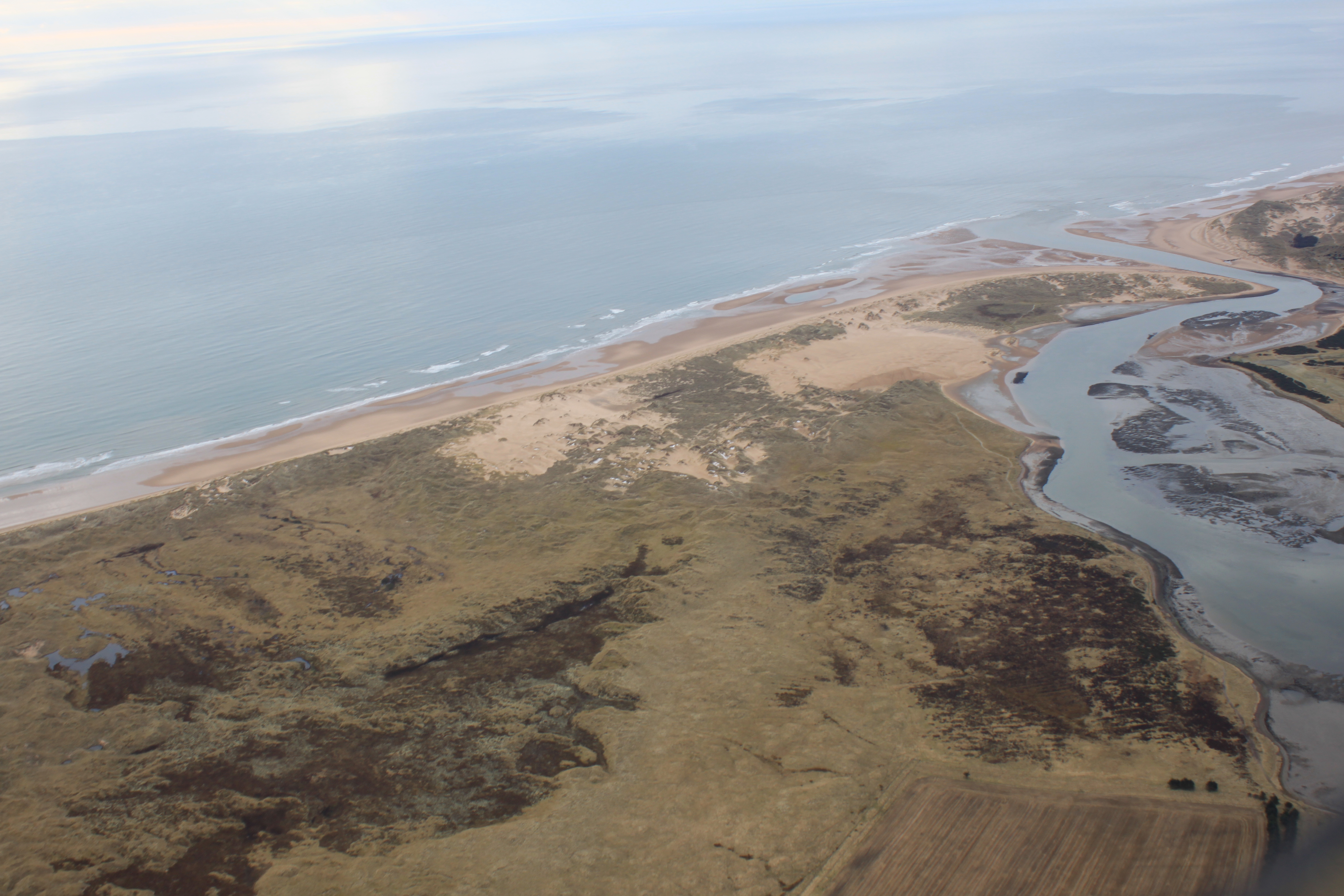
South Broad Haven is renowned for its pristine sandy beach, which stretches for approximately 2 kilometers. The soft golden sands provide the perfect spot for sunbathing, picnicking, or simply taking a leisurely stroll along the shore. The beach is also a popular destination for water sports enthusiasts, with opportunities for surfing, windsurfing, and kiteboarding.

Surrounded by rolling hills and cliffs, South Broad Haven offers breathtaking panoramic views of the North Sea. The bay is a haven for wildlife, with various seabirds, seals, and even dolphins often spotted in the area. It is also a designated Site of Special Scientific Interest, highlighting its ecological importance.

Visitors to South Broad Haven can explore the nearby coastal trails, which offer spectacular vistas of the surrounding landscape. The bay is also conveniently located near several charming villages and towns, where visitors can enjoy local cuisine and browse unique shops.

South Broad Haven is a hidden gem in Aberdeenshire, offering a peaceful retreat from the hustle and bustle of city life. Whether you are seeking relaxation on the beach, adventure in the water, or simply a scenic escape, South Broad Haven is a must-visit destination.

If you have any feedback on the listing, please let us know in the comments section below.

South Broad Haven Images

Images are sourced within 2km of 57.336738/-1.9501003 or Grid Reference NK0327. Thanks to Geograph Open Source API. All images are credited.

Slains Kirk, Collieston
Creels Fishing paraphernalia on the beach at Collieston.
Creels
Fishing paraphernalia on the beach at Collieston.
Former fishermans' cottages, Collieston
Road out of the village
The Old Manse, Collieston
The big rock behind the car park, Collieston
Rocky coast, Collieston Unforgiving rocks stretch for several kilometres either side of the narrow entrance to Collieston harbour.
Rocky coast, Collieston
Unforgiving rocks stretch for several kilometres either side of the narrow entrance to Collieston harbour.
Harbour views, Collieston
Forvie: the view along the beach to Rockend Almost at the northern limit of the wide sandy beach that runs some 12 miles from Aberdeen in the south to Rockend in the north. A windy day with rough seas that have carved intricate patterns into the sand.
Forvie: the view along the beach to Rockend
Almost at the northern limit of the wide sandy beach that runs some 12 miles from Aberdeen in the south to Rockend in the north. A windy day with rough seas that have carved intricate patterns into the sand.
Collieston: walrus This walrus was photographed on the rocks in Collieston, in 1954, by the late Dr Bruce Forman. It was the first UK record in 100 years.
Collieston: walrus
This walrus was photographed on the rocks in Collieston, in 1954, by the late Dr Bruce Forman. It was the first UK record in 100 years.
Old winch at Collieston Harbour Boats at Collieston are pulled up on the hill, well above the high water mark. Other fishing paraphernalia, including this winch, creels and float, are also stored ere.
Old winch at Collieston Harbour
Boats at Collieston are pulled up on the hill, well above the high water mark. Other fishing paraphernalia, including this winch, creels and float, are also stored ere.
Entrance to Collieston Harbour Viewed from the southern side of the harbour.
Entrance to Collieston Harbour
Viewed from the southern side of the harbour.
Collieston on a sunny day Collieston from the Kirkton of Slains headland.
Collieston on a sunny day
Collieston from the Kirkton of Slains headland.
Forvie Visitor Centre The visitor centre at the north end of Forvie National Nature Reserve
Forvie Visitor Centre
The visitor centre at the north end of Forvie National Nature Reserve
Hackley Head at low tide A particularly low tide today, so this headland was worth a look to see if I could get into NK0326. No chance, I was 60m short, with a yawning gap below me ( rock-climbers only ), and I don't believe there is any rock showing 60m ahead.
Hackley Head at low tide
A particularly low tide today, so this headland was worth a look to see if I could get into NK0326. No chance, I was 60m short, with a yawning gap below me ( rock-climbers only ), and I don't believe there is any rock showing 60m ahead.
Rockend rocks from Hackley Head The sands in the distance stretch all the way to Aberdeen. Note the glorious weather - something about " a 100% probability of severe cold weather/icy conditions " down south.
Rockend rocks from Hackley Head
The sands in the distance stretch all the way to Aberdeen. Note the glorious weather - something about " a 100% probability of severe cold weather/icy conditions " down south.
Tarness Haven View across the harbour and pier at Collieston towards Tarness Haven.
<span class="nowrap"><a title="http://en.wikipedia.org/wiki/Collieston" rel="nofollow ugc noopener" href="http://en.wikipedia.org/wiki/Collieston">Link</a><img style="margin-left:2px;" alt="External link" title="External link - shift click to open in new window" src="https://s1.geograph.org.uk/img/external.png" width="10" height="10"/></span>
Tarness Haven
View across the harbour and pier at Collieston towards Tarness Haven. LinkExternal link
Low Town, Collieston Cottages clustered around the harbour at Collieston.
<span class="nowrap"><a title="http://en.wikipedia.org/wiki/Collieston" rel="nofollow ugc noopener" href="http://en.wikipedia.org/wiki/Collieston">Link</a><img style="margin-left:2px;" alt="External link" title="External link - shift click to open in new window" src="https://s1.geograph.org.uk/img/external.png" width="10" height="10"/></span>
Low Town, Collieston
Cottages clustered around the harbour at Collieston. LinkExternal link
Show me another place!

South Broad Haven is located at Grid Ref: NK0327 (Lat: 57.336738, Lng: -1.9501003)

Unitary Authority: Aberdeenshire

Police Authority: North East

What 3 Words

///dentures.plant.reboot. Near Newburgh, Aberdeenshire

Related Wikis

Hackley Head

Hackley Head (otherwise Forvie Ness) is a headland in Aberdeenshire, northeast Scotland. Hackley Head is located to the south of Hackley Bay and to the...

Ythan Estuary

The Ythan Estuary (Scottish Gaelic: Inbhir Eithein) is the tidal component of the Ythan River, emptying into the North Sea 19 kilometres (12 mi) north...

Forvie

Forvie was a village in what is now the Forvie National Nature Reserve, located at the modern location of Rockend some fourteen miles north of Aberdeen...

Collieston

Collieston is a small former fishing village on the North Sea coast in Aberdeenshire, Scotland. The village lies just north of the Sands of Forvie Special...

Cotehill Loch

Cotehill Loch is a freshwater loch located in Scotland in the Aberdeenshire area, approximately one mile (1.5 km) northwest of the coastal town of Collieston...

Old Slains Castle

Slains Castle (otherwise known as Old Slains Castle) is a ruined castle near Collieston in Aberdeenshire, Scotland. It is not to be confused with New Slains...

Meikle Loch

Meikle Loch is an inland loch some miles north of Collieston, Aberdeenshire, Scotland. It is designated as part of the Ythan Estuary complex, along with...

Forvie National Nature Reserve

The Forvie National Nature Reserve is a national nature reserve owned and managed by NatureScot. It is located north of Newburgh in Aberdeenshire, in the...

Nearby Amenities

Located within 500m of 57.336738,-1.9501003
Source: Old Landsat image trace
Lat/Long: 57.3389916/-1.9432838
Source: Old Landsat image trace
Lat/Long: 57.3389453/-1.9435628
Source: Old Landsat image trace
Lat/Long: 57.3383895/-1.9456656
Source: Old Landsat image trace
Lat/Long: 57.3385053/-1.945966
Source: Old Landsat image trace
Lat/Long: 57.3384068/-1.9462128
Source: Old Landsat image trace
Lat/Long: 57.338459/-1.9466741
Source: Old Landsat image trace
Lat/Long: 57.3375325/-1.9479401
Source: Old Landsat image trace
Lat/Long: 57.3369419/-1.949292
Source: Old Landsat image trace
Lat/Long: 57.3369188/-1.9493456
Source: Old Landsat image trace
Lat/Long: 57.3368551/-1.9510944
Source: Old Landsat image trace
Lat/Long: 57.3359112/-1.9513626
Source: Old Landsat image trace
Lat/Long: 57.3358649/-1.9514592
Source: Old Landsat image trace
Lat/Long: 57.3358649/-1.951663
Source: Old Landsat image trace
Lat/Long: 57.3345852/-1.9543023
Source: Old Landsat image trace
Lat/Long: 57.3342783/-1.9546778
Source: Old Landsat image trace
Lat/Long: 57.3344636/-1.9548066
Source: Old Landsat image trace
Lat/Long: 57.3343825/-1.9555147
Source: Old Landsat image trace
Lat/Long: 57.3341914/-1.9558902
Source: Old Landsat image trace
Lat/Long: 57.3338649/-1.9562425
Bennet's Love
Place: locality
Lat/Long: 57.3385021/-1.9443509
Marywalls
Place: locality
Lat/Long: 57.3370929/-1.9480737
Corbie Holes
Place: locality
Lat/Long: 57.3355397/-1.9513487
Hackley Bay
Place: locality
Lat/Long: 57.3333298/-1.954414
The data included in this document is from www.openstreetmap.org. The data is made available under ODbL.

Have you been to South Broad Haven?

Leave your review of South Broad Haven below (or comments, questions and feedback).