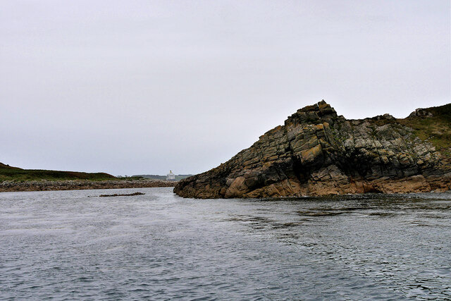
East Porth

Bay in Cornwall

England

East Porth

Trig pillar
Trig pillar Credit: Alex McGregor

East Porth, Cornwall, also known as East Porth Bay, is a picturesque coastal area located in the southwestern region of England. Situated in the county of Cornwall, East Porth Bay is renowned for its stunning natural beauty and pristine sandy beach. The bay is nestled between rugged cliffs and boasts crystal-clear turquoise waters, making it a popular destination for both locals and tourists.

The beach at East Porth Bay stretches for approximately half a mile, providing ample space for visitors to relax, sunbathe, and enjoy various beach activities. The soft golden sand is ideal for building sandcastles and beach games, while the shallow waters offer safe swimming conditions for families with young children. Lifeguards are present during peak seasons to ensure the safety of beachgoers.

Beyond the beach, East Porth Bay offers spectacular coastal walks and breathtaking views. Visitors can explore the surrounding cliffs, which are home to an abundance of wildlife and provide excellent opportunities for birdwatching. The bay also serves as a starting point for the South West Coast Path, a famous long-distance hiking trail that spans the entire Cornwall coastline.

Facilities at East Porth Bay include a car park and public toilets, providing convenience to visitors. Additionally, a café and beachside restaurant offer a variety of refreshments and local delicacies. The bay is easily accessible by road, with regular bus services connecting it to nearby towns and villages.

Overall, East Porth Bay in Cornwall offers a delightful combination of natural beauty, sandy beaches, and coastal exploration, making it an idyllic destination for those seeking a peaceful and scenic retreat.

If you have any feedback on the listing, please let us know in the comments section below.

East Porth Images

Images are sourced within 2km of 49.951737/-6.2550105 or Grid Reference SV9414. Thanks to Geograph Open Source API. All images are credited.

Trig pillar
Trig pillar
A track on eastern St Martin’s The track runs uphill from the eastern end of Higher Town Bay to the Chapel Down and the Daymark.
A track on eastern St Martin’s
The track runs uphill from the eastern end of Higher Town Bay to the Chapel Down and the Daymark.
The Daymark From within the ruins of the Admiralty signal station of  1805.

The signal station is included in the Scheduled Monument comprising the whole of Chapel down and is described thus:

In 1804, an Admiralty signal station was built on northern Chapel Down to communicate with naval vessels by signal mast and to report on enemy shipping movements. It was decommissioned in 1815, superseded by semaphore operated from St Mary's. Its main building stands to 2.3m high in the north of a subrectangular enclosure 38m long, NNW-SSE, by up to 21m wide.

List Entry Number:1016508  <span class="nowrap"><a title="https://historicengland.org.uk/listing/the-list/list-entry/1016508?section=official-list-entry" rel="nofollow ugc noopener" href="https://historicengland.org.uk/listing/the-list/list-entry/1016508?section=official-list-entry">Link</a><img style="margin-left:2px;" alt="External link" title="External link - shift click to open in new window" src="https://s1.geograph.org.uk/img/external.png" width="10" height="10"/></span>

The Daymark is separately listed Grade II*

List Entry Number:1141204 <span class="nowrap"><a title="https://historicengland.org.uk/listing/the-list/list-entry/1141204?section=official-list-entry" rel="nofollow ugc noopener" href="https://historicengland.org.uk/listing/the-list/list-entry/1141204?section=official-list-entry">Link</a><img style="margin-left:2px;" alt="External link" title="External link - shift click to open in new window" src="https://s1.geograph.org.uk/img/external.png" width="10" height="10"/></span>
The Daymark
From within the ruins of the Admiralty signal station of 1805. The signal station is included in the Scheduled Monument comprising the whole of Chapel down and is described thus: In 1804, an Admiralty signal station was built on northern Chapel Down to communicate with naval vessels by signal mast and to report on enemy shipping movements. It was decommissioned in 1815, superseded by semaphore operated from St Mary's. Its main building stands to 2.3m high in the north of a subrectangular enclosure 38m long, NNW-SSE, by up to 21m wide. List Entry Number:1016508 LinkExternal link The Daymark is separately listed Grade II* List Entry Number:1141204 LinkExternal link
Isles of Scilly, Eastern Isles from Crow Sound The large island in the background is St Martin's.
Isles of Scilly, Eastern Isles from Crow Sound
The large island in the background is St Martin's.
Isles of Scilly. Little Ganinick One of the Eastern Isles, a group of twelve small uninhabited islands within the Isles of Scilly Area of Outstanding Natural Beauty. Part of the larger island of Great Ganinick (with more vegetation) can be seen behind (and slightly to the right of) Little Ganinick.
Isles of Scilly. Little Ganinick
One of the Eastern Isles, a group of twelve small uninhabited islands within the Isles of Scilly Area of Outstanding Natural Beauty. Part of the larger island of Great Ganinick (with more vegetation) can be seen behind (and slightly to the right of) Little Ganinick.
Isles of Scilly, Great Arthur Great, Middle and Little Arthur are three of the Eastern Isles, a group of twelve small uninhabited islands within the Isles of Scilly Area of Outstanding Natural Beauty. Great Arthur, as its name suggests, is the largest of the three.
Isles of Scilly, Great Arthur
Great, Middle and Little Arthur are three of the Eastern Isles, a group of twelve small uninhabited islands within the Isles of Scilly Area of Outstanding Natural Beauty. Great Arthur, as its name suggests, is the largest of the three.
Isles of Scilly, Rocky Ledge between Middle and Great Arthur Great, Middle and Little Arthur are three of the Eastern Isles, a group of twelve small uninhabited islands within the Isles of Scilly Area of Outstanding Natural Beauty. Great Arthur, as its name suggests, is the largest of the three.
Isles of Scilly, Rocky Ledge between Middle and Great Arthur
Great, Middle and Little Arthur are three of the Eastern Isles, a group of twelve small uninhabited islands within the Isles of Scilly Area of Outstanding Natural Beauty. Great Arthur, as its name suggests, is the largest of the three.
Isles of Scilly, Middle Arthur Great, Middle and Little Arthur are three of the Eastern Isles, a group of twelve small uninhabited islands within the Isles of Scilly Area of Outstanding Natural Beauty. Great Arthur, as its name suggests, is the largest of the three.
Isles of Scilly, Middle Arthur
Great, Middle and Little Arthur are three of the Eastern Isles, a group of twelve small uninhabited islands within the Isles of Scilly Area of Outstanding Natural Beauty. Great Arthur, as its name suggests, is the largest of the three.
Middle Arthur, Arthur Quay Great, Middle and Little Arthur are three of the Eastern Isles, a group of twelve small uninhabited islands within the Isles of Scilly Area of Outstanding Natural Beauty. Great Arthur, as its name suggests, is the largest of the three.

The three rocky islands are joined by two beaches forming a crescent around Arthur Porth.
Middle Arthur, Arthur Quay
Great, Middle and Little Arthur are three of the Eastern Isles, a group of twelve small uninhabited islands within the Isles of Scilly Area of Outstanding Natural Beauty. Great Arthur, as its name suggests, is the largest of the three. The three rocky islands are joined by two beaches forming a crescent around Arthur Porth.
Rocky Shore, Little Ganilly Little Ganilly (Cornish: Goonhyli Bian, little salt water down) lies just to the north of Little Arthur.
Rocky Shore, Little Ganilly
Little Ganilly (Cornish: Goonhyli Bian, little salt water down) lies just to the north of Little Arthur.
Great Ganilly, West Porth Great Ganilly (Cornish: Goonhyli Meur) is the largest of the Eastern Isles and consists of two hills joined together by a low sandy neck.
Great Ganilly, West Porth
Great Ganilly (Cornish: Goonhyli Meur) is the largest of the Eastern Isles and consists of two hills joined together by a low sandy neck.
Isles of Scilly, Nornour Nornour (Cornish: Ar No) consists of one hill covered in bracken. It lies to the north of Great Ganilly to which it is joined by a boulder causeway at low tide. There is a small area of heath on the hill with heather and bell heather.
Isles of Scilly, Nornour
Nornour (Cornish: Ar No) consists of one hill covered in bracken. It lies to the north of Great Ganilly to which it is joined by a boulder causeway at low tide. There is a small area of heath on the hill with heather and bell heather.
Rocky Ledge between Nornour and Great Ganilly Nornour (Cornish: Ar No) consists of one hill covered in bracken. It is connected to Great Ganilly by a boulder causeway during low tide. The pyramidal island in the background is Hanjague, which is approximately 1 kilometre away.
Rocky Ledge between Nornour and Great Ganilly
Nornour (Cornish: Ar No) consists of one hill covered in bracken. It is connected to Great Ganilly by a boulder causeway during low tide. The pyramidal island in the background is Hanjague, which is approximately 1 kilometre away.
The Eastern Isles, Nornour Nornour (Cornish: Ar No) consists of one hill covered in bracken. It lies to the north of Great Ganilly and is connected to it by a boulder causeway that is visible only during low tide. There is a small area of heath on the hill with heather and bell heather.
The Eastern Isles, Nornour
Nornour (Cornish: Ar No) consists of one hill covered in bracken. It lies to the north of Great Ganilly and is connected to it by a boulder causeway that is visible only during low tide. There is a small area of heath on the hill with heather and bell heather.
Isles of Scilly, Nornour Nornour (Cornish: Ar No) consists of one hill covered in bracken. It lies to the north of Great Ganilly to which it is joined by a boulder causeway at low tide.
Isles of Scilly, Nornour
Nornour (Cornish: Ar No) consists of one hill covered in bracken. It lies to the north of Great Ganilly to which it is joined by a boulder causeway at low tide.
Rocks on the North Coast of Nornour The Eastern Isles (Cornish: Enesow Goonhyli) are a group of twelve small uninhabited islands  located to the south–east of St Martin's. The islands lie within the Isles of Scilly Area of Outstanding Natural Beauty, part of the Scilly Heritage Coast and a Site of Special Scientific Interest (SSSI) first designated in 1971 for its flora and fauna (<span class="nowrap"><a title="https://en.wikipedia.org/wiki/Eastern_Isles" rel="nofollow ugc noopener" href="https://en.wikipedia.org/wiki/Eastern_Isles">Link</a><img style="margin-left:2px;" alt="External link" title="External link - shift click to open in new window" src="https://s1.geograph.org.uk/img/external.png" width="10" height="10"/></span> Wikipedia).
Rocks on the North Coast of Nornour
The Eastern Isles (Cornish: Enesow Goonhyli) are a group of twelve small uninhabited islands located to the south–east of St Martin's. The islands lie within the Isles of Scilly Area of Outstanding Natural Beauty, part of the Scilly Heritage Coast and a Site of Special Scientific Interest (SSSI) first designated in 1971 for its flora and fauna (LinkExternal link Wikipedia).
Isles of Scilly, Nornour The Eastern Isles (Cornish: Enesow Goonhyli) are a group of twelve small uninhabited islands  located to the south–east of St Martin's. The islands lie within the Isles of Scilly Area of Outstanding Natural Beauty, part of the Scilly Heritage Coast and a Site of Special Scientific Interest (SSSI) first designated in 1971 for its flora and fauna (<span class="nowrap"><a title="https://en.wikipedia.org/wiki/Eastern_Isles" rel="nofollow ugc noopener" href="https://en.wikipedia.org/wiki/Eastern_Isles">Link</a><img style="margin-left:2px;" alt="External link" title="External link - shift click to open in new window" src="https://s1.geograph.org.uk/img/external.png" width="10" height="10"/></span> Wikipedia).
Isles of Scilly, Nornour
The Eastern Isles (Cornish: Enesow Goonhyli) are a group of twelve small uninhabited islands located to the south–east of St Martin's. The islands lie within the Isles of Scilly Area of Outstanding Natural Beauty, part of the Scilly Heritage Coast and a Site of Special Scientific Interest (SSSI) first designated in 1971 for its flora and fauna (LinkExternal link Wikipedia).
Isles of Scilly Eastern Isles Looking through the gap between Nornour (on the right) and Great Ganilly.
Isles of Scilly Eastern Isles
Looking through the gap between Nornour (on the right) and Great Ganilly.
Show me another place!

East Porth is located at Grid Ref: SV9414 (Lat: 49.951737, Lng: -6.2550105)

Division: Isles of Scilly

Unitary Authority: Isles of Scilly

Police Authority: Devon and Cornwall

What 3 Words

///listed.eggplants.reckoned. Near St Martin's, Isles of Scilly

Related Wikis

Great Ganilly

Great Ganilly ( gə-NIL-ee; Cornish: Goonhyli Veur, lit. 'great saltwater downs') is one of the Eastern Isles of the Isles of Scilly. It has a maximum total...

Eastern Isles

The Eastern Isles (Cornish: Enesow Goonhyli, islands of the salt water downs) are a group of twelve small uninhabited islands within the Isles of Scilly...

PS Earl of Arran (1860)

PS Earl of Arran was a passenger vessel operated by the Ardrossan Steamboat Company from 1860 to 1871 and the West Cornwall Steam Ship Company from 1871...

Wheel Wreck

The Wheel Wreck is the remains of a shipwreck lying in Crow sound off Little Ganinick in the Isles of Scilly. The wreck site consists of a discrete mound...

Related Videos

St Martins - Isles of Scilly BEAUTIFUL

St Martins - Isles of Scilly BEAUTIFUL Filmed and Edited by Paul Dinning - Wildlife in Cornwall Original Music Written and ...
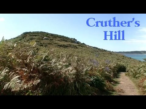
Cruther's Hill

Cruther's Hill is a hill near Higher Town on St Martin's, Isles of Scilly. From on top of the hill, there are views of St Mary's, Tresco ...

Par Beach, St Martin's

Par Beach, also known as Higher Town Bay and Higher Town Beach, is a beautiful beach on the island of St Martin's, Isles of ...

Higher Town, St Martin's

Higher Town is the main settlement on St Martin's on the Isles of Scilly. Higher Town has a church, a Methodist church, a post ...

Nearby Amenities

Located within 500m of 49.951737,-6.2550105
Eastern Isles
Place: island
Wikidata: Q1278198
Wikipedia: en:Eastern Isles
Lat/Long: 49.9495656/-6.2610838
Natural: peak
Lat/Long: 49.9500643/-6.2561919
West Porth
Natural: bay
Lat/Long: 49.9509187/-6.258246
The data included in this document is from www.openstreetmap.org. The data is made available under ODbL.

Have you been to East Porth?

Leave your review of East Porth below (or comments, questions and feedback).