Thomas' Porth

Bay in Cornwall

England

Thomas' Porth

Church Point
Church Point Credit: David Lally

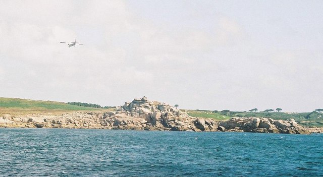
Thomas' Porth is a picturesque bay located in the county of Cornwall, England. Situated on the southwestern coast, it boasts stunning views of the Atlantic Ocean and is a popular destination for locals and tourists alike. The bay is named after Thomas, a local fisherman who was known for his exceptional knowledge of the area's waters.

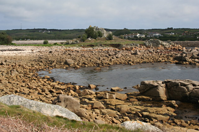
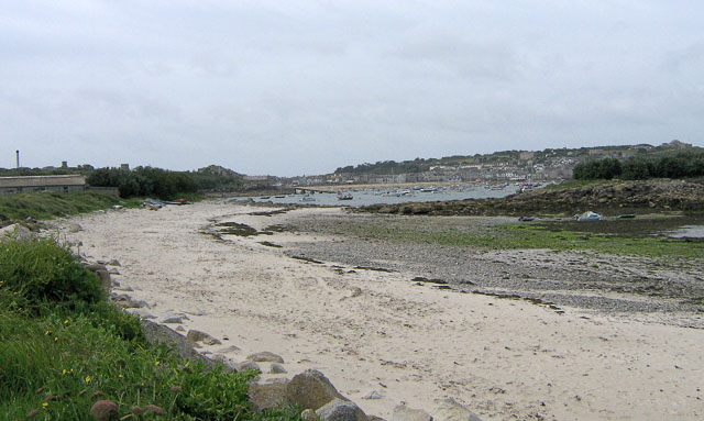
The beach at Thomas' Porth is a sandy stretch that is ideal for sunbathing, picnicking, and family outings. It is a well-maintained area with clean sands and clear waters, making it perfect for swimming and other water activities. The bay is also sheltered from strong currents, making it a safe spot for children to paddle and play.

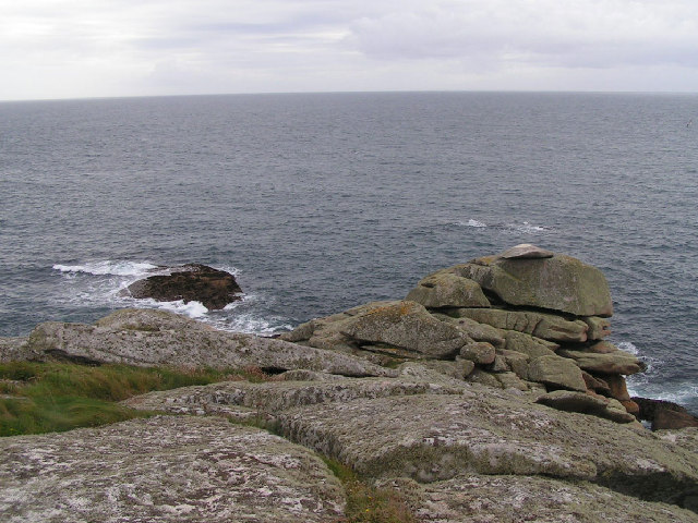
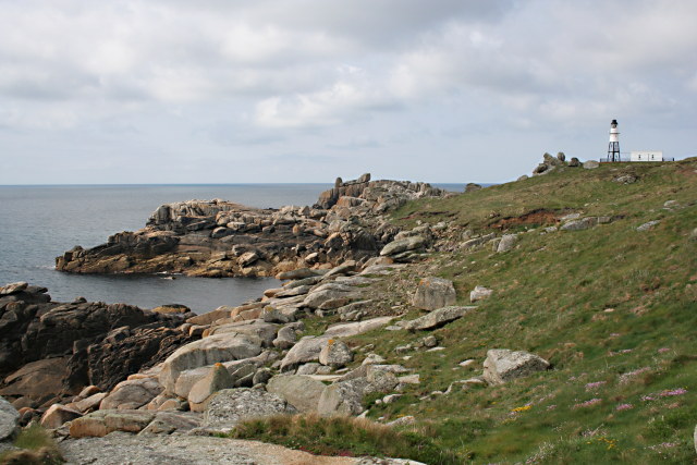
Surrounding the bay are towering cliffs that provide a dramatic backdrop to the beach. These cliffs are a haven for birdwatchers, as they are home to a variety of seabirds such as gulls, cormorants, and even the occasional peregrine falcon. Visitors can enjoy breathtaking views from the top of the cliffs, making it a popular spot for nature enthusiasts and photographers.

Thomas' Porth is also known for its vibrant marine life. Snorkelers and divers can explore the underwater world that teems with colorful fish, starfish, and even the occasional seal. The bay is a designated Marine Conservation Area, ensuring the preservation of its diverse ecosystem.

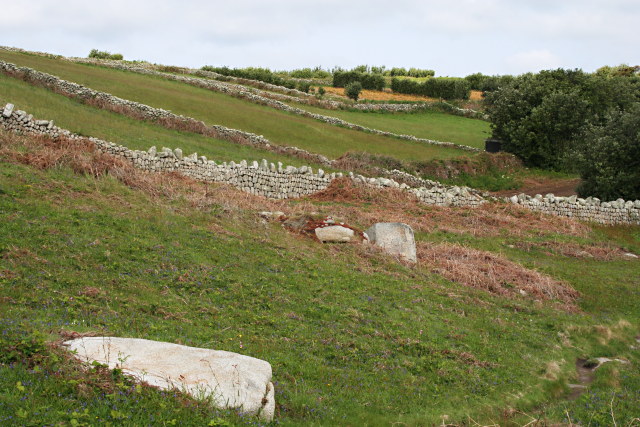
Facilities at Thomas' Porth include a car park, toilets, and a small café that serves refreshments. There are also coastal paths that allow visitors to explore the surrounding area, including nearby coves and villages.

Overall, Thomas' Porth offers a tranquil and captivating coastal experience, combining natural beauty with recreational opportunities for all.

If you have any feedback on the listing, please let us know in the comments section below.

Thomas' Porth Images

Images are sourced within 2km of 49.919875/-6.3092565 or Grid Reference SV9011. Thanks to Geograph Open Source API. All images are credited.

Church Point
Church Point
Pillbox entrance On Tolman Point.
Pillbox entrance
On Tolman Point.
Rock formations at Peninnis Head
Morning Point, the Garrison Looking SE to the offshore rocks Wras and (behind and smaller) Biggal; Inner Head <a href="https://www.geograph.org.uk/gridref/SV908093">SV908093</a> (part of Peninnis Head) is just visible to the far left, on the other side of Porth Cressa bay. Note the passing storm on the horizon...
Morning Point, the Garrison
Looking SE to the offshore rocks Wras and (behind and smaller) Biggal; Inner Head SV908093 (part of Peninnis Head) is just visible to the far left, on the other side of Porth Cressa bay. Note the passing storm on the horizon...
Peninnis Head Looking SSE to the lighthouse from approx. SV910097.
Peninnis Head
Looking SSE to the lighthouse from approx. SV910097.
Old Town Bay from Peninnis There is a former Battery on the island to the right of the pine tree.
Old Town Bay from Peninnis
There is a former Battery on the island to the right of the pine tree.
Tolman Point Viewed from the north on the very edge of the square; note the WW2 pillbox.
Tolman Point
Viewed from the north on the very edge of the square; note the WW2 pillbox.
Church Point The end of Church Point (just below the end of the main runway of St Mary's Airport) looking out to sea; this (and a rock off the end of Giant's Castle) is the only land in the square.
Church Point
The end of Church Point (just below the end of the main runway of St Mary's Airport) looking out to sea; this (and a rock off the end of Giant's Castle) is the only land in the square.
Lighthouse at Peninnis Head, St. Mary's The lighthouse guides shipping passing through St. Mary's Sound, between the islands of Agnes and St. Mary's.  The lattice-work construction reduces its wind resistance.
Lighthouse at Peninnis Head, St. Mary's
The lighthouse guides shipping passing through St. Mary's Sound, between the islands of Agnes and St. Mary's. The lattice-work construction reduces its wind resistance.
St. Mary’s: Peninnis Point Viewed from the ferry from Penzance shortly before arrival on the island.
St. Mary’s: Peninnis Point
Viewed from the ferry from Penzance shortly before arrival on the island.
St. Mary’s: plane over Church Point A plane approaches Scilly's airport, viewed from the ferry from Penzance.
St. Mary’s: plane over Church Point
A plane approaches Scilly's airport, viewed from the ferry from Penzance.
Photographing the Rock Labyrinth The area between the lighthouse and the Outer Head is appropriately known as the Rock Labyrinth. In younger (and slimmer) days we would explore this fantastic maze of huge granite rocks.
Photographing the Rock Labyrinth
The area between the lighthouse and the Outer Head is appropriately known as the Rock Labyrinth. In younger (and slimmer) days we would explore this fantastic maze of huge granite rocks.
Carn Leh, St. Mary's, Scilly Isles
Footpath on Peninnis Head, St. Mary's, Scilly Isles
Granite Stone Walls Granite is pretty much the only rock there is on the Scillies and there's plenty of it, so it makes sense to build your field walls out of it.
Granite Stone Walls
Granite is pretty much the only rock there is on the Scillies and there's plenty of it, so it makes sense to build your field walls out of it.
Fields on the eastern side of Peninnis The field at the bottom of the hill on the right is being used for bulb growing, the others look as though they have been left to grass.
Fields on the eastern side of Peninnis
The field at the bottom of the hill on the right is being used for bulb growing, the others look as though they have been left to grass.
Carn Leh Cove The headland of Carn Leh separates this small cove from the larger Old Town Bay.
Carn Leh Cove
The headland of Carn Leh separates this small cove from the larger Old Town Bay.
Peninnis Head Looking towards the Outer Head and the Lighthouse.
Peninnis Head
Looking towards the Outer Head and the Lighthouse.
Show me another place!

Thomas' Porth is located at Grid Ref: SV9011 (Lat: 49.919875, Lng: -6.3092565)

Division: Isles of Scilly

Unitary Authority: Isles of Scilly

Police Authority: Devon and Cornwall

What 3 Words

///catchers.shared.ballparks. Near St Mary's, Isles of Scilly

Related Wikis

St Mary's Lifeboat Station

St Mary's Lifeboat Station is situated in St Mary's Harbour, Isles of Scilly and has been an important station for the Royal National Lifeboat Institution...

Harry's Walls

Harry's Walls are the remains of an unfinished artillery fort, started in 1551 by the government of Edward VI to defend the island of St Mary's in the...

Porthloo

Porthloo (sometimes spelled and often pronounced Porthlow; Cornish: Porth Logh "cove of the deep water inlet") is a coastal settlement on the island of...

Rocky Hill, Isles of Scilly

Rocky Hill (Cornish: Breveynek) is a minor hill with a small settlement, on the island of St Mary's in the Isles of Scilly, England. Nearby are Porthloo...

Nearby Amenities

Located within 500m of 49.919875,-6.3092565
Source: PGS
Lat/Long: 49.9162752/-6.3121096
Source: PGS
Lat/Long: 49.9160949/-6.3123965
Source: PGS
Lat/Long: 49.9166313/-6.3102721
Source: PGS
Lat/Long: 49.9169469/-6.3111675
Source: PGS
Lat/Long: 49.9168025/-6.3115302
Source: PGS
Lat/Long: 49.9168208/-6.3114977
Source: PGS
Lat/Long: 49.920772/-6.3088462
Source: PGS
Lat/Long: 49.9219656/-6.3081028
Source: PGS
Lat/Long: 49.9235122/-6.308976
Source: PGS
Lat/Long: 49.9191167/-6.308172
Source: PGS
Lat/Long: 49.9188107/-6.3087066
Source: PGS
Lat/Long: 49.9202306/-6.3084512
Source: PGS
Lat/Long: 49.9202038/-6.308515
Isles of Scilly
Name Da: Scillyøerne
Name De: Scilly-Inseln
Name En: Isles of Scilly
Name Eo: Insuloj Scilly
Name Es: Islas Sorlingas
Name Fr: Îles Sorlingues
Name It: Isole Sorlinghe
Name Kw: Ynysek Syllan
Name Nl: Scilly-eilanden
Name Nn: Scillyøyane
Name No: Syllingene
Name Pt: Ilhas Sorlingas
Name Ro: Insulele Scilly
Name Sv: Scillyöarna
Place: archipelago
Lat/Long: 49.9189993/-6.3140034
Post Box
Ref: TR21 210
Lat/Long: 49.9170274/-6.3057698
Post Box
Operator: Royal Mail
Operator Wikidata: Q638098
Ref: TR21 180
Lat/Long: 49.9219979/-6.3077967
Ambulance Station
Emergency: ambulance_station
Lat/Long: 49.9160811/-6.3078981
Radio Scilly
Source: Bing
Website: http://www.radioscilly.com/
Lat/Long: 49.9164143/-6.3083469
Carn Thomas
Natural: peak
Source: Bing
Lat/Long: 49.9166957/-6.3113509
Source: PGS
Lat/Long: 49.9180077/-6.3079287
Cafe
The Dairy Cafe
Lat/Long: 49.9159299/-6.3113983
Taylor's Island
Place: islet
Wikidata: Q108332127
Lat/Long: 49.9235162/-6.3126145
Porthloo
Alt Name: Porthlow
Place: hamlet
Wikidata: Q7231783
Wikipedia: en:Porthloo
Lat/Long: 49.9223244/-6.3075645
Downderry
Place: locality
Lat/Long: 49.9155168/-6.3096211
Newford Island
Place: islet
Lat/Long: 49.9208568/-6.311091
St Mary's Pool
Natural: bay
Lat/Long: 49.918383/-6.3136839
Harry's Walls
Place: locality
Lat/Long: 49.9186878/-6.3069896
Leisure: slipway
Lat/Long: 49.9211714/-6.3088815
Rocky Hill
Place: hamlet
Wikidata: Q7355801
Wikipedia: en:Rocky Hill, Isles of Scilly
Lat/Long: 49.9198512/-6.3022846
Leisure: outdoor_seating
Operator: Juliet's Garden Restaurant & Bar
Lat/Long: 49.9242445/-6.3089448
Porthloo Boat Park
Leisure: marina
Operator: Duchy of Cornwall
Seamark Harbour Category: marina
Seamark Type: harbour
Lat/Long: 49.9213054/-6.3079439
Porth Loo
Natural: bay
Lat/Long: 49.9223274/-6.3111635
Bicycle Rental
Lat/Long: 49.9164829/-6.3072385
Car Rental
Scilly Hire Cart Co.
Lat/Long: 49.9158578/-6.308069
Rosehill Art Studio
Shop: art
Lat/Long: 49.9183503/-6.3050455
Sandy Banks
Place: isolated_dwelling
Lat/Long: 49.9168826/-6.3056348
Waste Basket
Lat/Long: 49.9175293/-6.3040392
Porthloo Studios
Shop: gift
Lat/Long: 49.9207323/-6.3078199
Mount Flagon
Natural: peak
Lat/Long: 49.9183444/-6.3067064
Flares
Shop: hairdresser
Lat/Long: 49.9163912/-6.3083959
Bicycle Rental
Opening Hours: Mo-Su 09:00-18:00
Lat/Long: 49.916377/-6.3077191
Generator Method: photovoltaic
Generator Output Electricity: yes
Generator Source: solar
Generator Type: solar_photovoltaic_panel
Location: roof
Power: generator
Lat/Long: 49.9186596/-6.3072976
Generator Method: photovoltaic
Generator Output Electricity: yes
Generator Source: solar
Generator Type: solar_photovoltaic_panel
Location: roof
Power: generator
Lat/Long: 49.9157495/-6.3116176
Generator Method: photovoltaic
Generator Output Electricity: yes
Generator Source: solar
Generator Type: solar_photovoltaic_panel
Location: roof
Power: generator
Lat/Long: 49.915771/-6.3115727
Generator Method: photovoltaic
Generator Output Electricity: yes
Generator Source: solar
Generator Type: solar_photovoltaic_panel
Location: roof
Power: generator
Lat/Long: 49.9157933/-6.3115261
Generator Method: photovoltaic
Generator Output Electricity: yes
Generator Source: solar
Generator Type: solar_photovoltaic_panel
Location: roof
Power: generator
Lat/Long: 49.9158161/-6.3114786
Generator Method: photovoltaic
Generator Output Electricity: yes
Generator Source: solar
Generator Type: solar_photovoltaic_panel
Location: roof
Power: generator
Lat/Long: 49.9158346/-6.3114399
Generator Method: photovoltaic
Generator Output Electricity: yes
Generator Source: solar
Generator Type: solar_photovoltaic_panel
Location: roof
Power: generator
Lat/Long: 49.9158237/-6.3095265
Generator Method: photovoltaic
Generator Output Electricity: yes
Generator Source: solar
Generator Type: solar_photovoltaic_panel
Location: roof
Power: generator
Lat/Long: 49.9160453/-6.3088808
Seamark Mooring Category: buoy
Seamark Mooring Colour: orange
Seamark Name: RNLI
Seamark Source: Bing
Seamark Type: mooring
Lat/Long: 49.9192493/-6.3146174
The Whiteheads
Water Rescue
Emergency: water_rescue
Operator: Royal National Lifeboat Institution
Operator Short: RNLI
Operator Wikidata: Q2166873
Ref: 17-11
Seamark Name: The Whiteheads
Seamark Radio Station Category: ais
Seamark Radio Station Mmsi: 232003049
Seamark Rescue Station Category: lifeboat_on_mooring
Seamark Source: Bing; https://rnli.org/find-my-nearest
Seamark Type: rescue_station
Website: https://rnli.org/find-my-nearest/lifeboat-stations/st-marys-lifeboat-station/our-lifeboats-st-marys-lifeboat-station
Lat/Long: 49.91912/-6.314725
Power: pole
Transformer: distribution
Lat/Long: 49.9205955/-6.3071957
Power: pole
Transformer: distribution
Lat/Long: 49.9212241/-6.3048086
Power: pole
Lat/Long: 49.9172282/-6.3049168
Power: pole
Transformer: distribution
Lat/Long: 49.9175914/-6.3056226
Seamark Landmark Category: cairn
Seamark Landmark Colour: white
Seamark Type: landmark
Lat/Long: 49.9186553/-6.3084244
Seamark Light Category: rear;vertical
Seamark Light Character: Oc
Seamark Light Colour: white;red
Seamark Light Period: 10
Seamark Type: light_minor
Lat/Long: 49.918541/-6.3069875
Seamark Light Category: front;vertical
Seamark Light Character: Oc
Seamark Light Colour: white;red
Seamark Light Period: 10
Seamark Type: light_minor
Lat/Long: 49.9186509/-6.3084081
Archaeological Site: megalith
Historic: archaeological_site
Lat/Long: 49.9185381/-6.3069597
Bench
Lat/Long: 49.9198328/-6.3076945
The data included in this document is from www.openstreetmap.org. The data is made available under ODbL.

Have you been to Thomas' Porth?

Leave your review of Thomas' Porth below (or comments, questions and feedback).