Carreg Mala-William

Island in Pembrokeshire

Wales

Carreg Mala-William

Dinas Head Seen from the road from Fishguard to Newport
Dinas Head Credit: Deborah Tilley

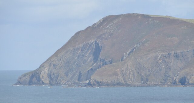
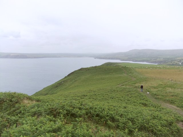
Carreg Mala-William is a small island located off the coast of Pembrokeshire in Wales, United Kingdom. It is situated in the Celtic Sea, approximately 0.6 miles northwest of Cardigan Island. This rocky outcrop is composed of rugged cliffs and is accessible only by boat.

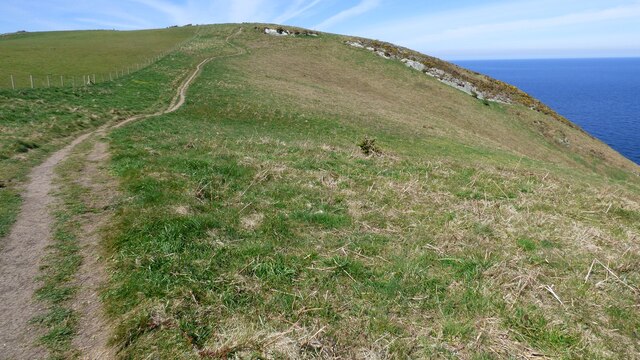
The island gets its name from a large rock formation resembling a "mala" or "hammer" in Welsh. Carreg Mala-William has a distinctive appearance with its sheer cliffs rising up to 50 feet above sea level. The island is uninhabited and lacks any significant vegetation, making it a haven for various bird species.

The island is a popular destination for birdwatchers, as it serves as a nesting site for many seabirds, including guillemots, razorbills, and kittiwakes. Visitors can observe these birds in their natural habitat, as well as spot other wildlife such as seals and dolphins in the surrounding waters.

Due to its remote location and limited access, Carreg Mala-William is not suitable for overnight stays or recreational activities such as hiking or swimming. However, boat tours and cruises often include this island as part of their itinerary, allowing visitors to admire its rugged beauty and enjoy the abundant wildlife.

Carreg Mala-William is a picturesque and tranquil island, offering a unique opportunity to connect with nature and experience the beauty of the Welsh coastline.

If you have any feedback on the listing, please let us know in the comments section below.

Carreg Mala-William Images

Images are sourced within 2km of 52.023384/-4.8931589 or Grid Reference SN0140. Thanks to Geograph Open Source API. All images are credited.

Dinas Head Seen from the road from Fishguard to Newport
Dinas Head
Seen from the road from Fishguard to Newport
Perilous point There is some inconsistency between different versions of the Ordnance Survey as to whether this or the next headland is Pen Sidan. Either way, the only reason for scrambling down here was to claim another green square! It's very steep and accessible only via paths made by sheep - and even they sometimes come a cropper, as reported in the local newspaper recently:

"Things went a bit woolly for Fishguard's inshore lifeboat crew yesterday afternoon, as they had a sheep on board.
The animal had become stranded at the bottom of a cliff near Dinas Head. Fishguard coastguard rescue team was also called to the scene.
The baaad sheep was helped aboard the inshore lifeboat, who landed in a safe place. They then delivered the animal to the coastguard team who took her back to the farmer."
Perilous point
There is some inconsistency between different versions of the Ordnance Survey as to whether this or the next headland is Pen Sidan. Either way, the only reason for scrambling down here was to claim another green square! It's very steep and accessible only via paths made by sheep - and even they sometimes come a cropper, as reported in the local newspaper recently: "Things went a bit woolly for Fishguard's inshore lifeboat crew yesterday afternoon, as they had a sheep on board. The animal had become stranded at the bottom of a cliff near Dinas Head. Fishguard coastguard rescue team was also called to the scene. The baaad sheep was helped aboard the inshore lifeboat, who landed in a safe place. They then delivered the animal to the coastguard team who took her back to the farmer."
Inaccessible cove Tiny bay visitable only by boat: note the float and line left to mark the spot a lobster pot has been dropped.
Inaccessible cove
Tiny bay visitable only by boat: note the float and line left to mark the spot a lobster pot has been dropped.
Gull's egg The egg has been broken into and the torn shell left lying in the grass. Another bird is most likely to have been the culprit.
Gull's egg
The egg has been broken into and the torn shell left lying in the grass. Another bird is most likely to have been the culprit.
Dinas Head The rugged promontory of Dinas Head (142m amsl) - seen here from Saddle Point above Fishguard Harbour.
Dinas Head
The rugged promontory of Dinas Head (142m amsl) - seen here from Saddle Point above Fishguard Harbour.
Cliffs at Pen Castell
Pembrokeshire Coast Path leading up Pen y Fan
St Brynach's Church
St Brynach's Church
Pwll Glas on Dinas Island
View of the coast from near Pen Castell
Coast path heading north
Church of St Brynach remains At Cwm-yr-Eglwys
Church of St Brynach remains
At Cwm-yr-Eglwys
Cwm-yr-Eglwys Beach View from the sea wall round to Pig y Baw
Cwm-yr-Eglwys Beach
View from the sea wall round to Pig y Baw
Cwm-yr-Eglwys Beach View to Trywn Isaac with more of the sea defences on the far right
Cwm-yr-Eglwys Beach
View to Trywn Isaac with more of the sea defences on the far right
Remains of St Brynach's church
Trig Point on Pen y Fan, Dinas Head
Churchyard and ruined church, Cwm yr Eglwys All that remains of the church of St Brynach, the rest having been washed away by the so-called Royal Charter Storm of October 1859.   A somewhat melancholy sight, all the more so on a drizzly afternoon. 

As for the meaning of the name, if this were Cornwall rather than West Wales, the wording on the map might well be 'Church Cove'.
Churchyard and ruined church, Cwm yr Eglwys
All that remains of the church of St Brynach, the rest having been washed away by the so-called Royal Charter Storm of October 1859. A somewhat melancholy sight, all the more so on a drizzly afternoon. As for the meaning of the name, if this were Cornwall rather than West Wales, the wording on the map might well be 'Church Cove'.
The Pembrokeshire Coast path east of Dinas Head Seen from a few hundred metres east of the trig. point at Pen y Fan - on a drizzly afternoon.  In the distance is the Nevern Estuary, Aber yr Afon Nyfer.  Ahead of me on the path is Casey, a Jack Russell terrier often to be seen in Pembrokeshire Geographs: <a title="https://www.geograph.org.uk/photo/301958," href="https://www.geograph.org.uk/photo/301958,">Link</a> <a title="https://www.geograph.org.uk/photo/2188741" href="https://www.geograph.org.uk/photo/2188741">Link</a>
The Pembrokeshire Coast path east of Dinas Head
Seen from a few hundred metres east of the trig. point at Pen y Fan - on a drizzly afternoon. In the distance is the Nevern Estuary, Aber yr Afon Nyfer. Ahead of me on the path is Casey, a Jack Russell terrier often to be seen in Pembrokeshire Geographs: Link Link
Show me another place!

Carreg Mala-William is located at Grid Ref: SN0140 (Lat: 52.023384, Lng: -4.8931589)

Unitary Authority: Pembrokeshire

Police Authority: Dyfed Powys

What 3 Words

///stunning.stung.sank. Near Newport, Pembrokeshire

Related Wikis

Cwm-yr-Eglwys

Cwm-yr-Eglwys (English: Valley of the Church) is a hamlet in a picturesque cove on the eastern side of the Dinas Island peninsula in the community of Dinas...

Dinas Island

Dinas Island (Welsh: Ynys Dinas) is a peninsula, partially detached from the mainland, in the community of Dinas Cross between Fishguard and Newport, Pembrokeshire...

Brynhenllan

Bryn-henllan, Bryn Henllan or Brynhenllan is a small settlement in the community of Dinas Cross, north Pembrokeshire, Wales, just north of the A487 road...

Cwm Dewi

Cwm Dewi is a Site of Special Scientific Interest (or SSSI) in Pembrokeshire, South Wales. It has been designated as a Site of Special Scientific Interest...

Nearby Amenities

Located within 500m of 52.023384,-4.8931589
Cwm-yr-Eglwys
Created By: Potlatch 0.9b
Is In: Pembrokeshire
Place: hamlet
Wikidata: Q5197179
Lat/Long: 52.023018/-4.8955484
Toilets
Source: survey
Lat/Long: 52.0236264/-4.895611
Post Box
Collection Times: Mo-Fr 09:15; Sa 09:15
Operator: Royal Mail
Post Box Type: wall
Ref: SA42 66
Royal Cypher: VR
Source: survey
Survey Date: 2023-06-19
Lat/Long: 52.0229675/-4.8947189
Bench
Lat/Long: 52.0238113/-4.8949582
Bench
Lat/Long: 52.0237606/-4.8948414
Bench
Lat/Long: 52.0236914/-4.8947937
Bench
Lat/Long: 52.0236212/-4.8947413
Give Way
Direction: forward
Lat/Long: 52.0230908/-4.8953769
Aber Gwyn
Natural: bay
Lat/Long: 52.0237057/-4.8918721
Saint Brynach's Belfry
Historic: archaeological_site
Lat/Long: 52.0234984/-4.8946682
Leisure: slipway
Lat/Long: 52.0233783/-4.8945234
Bench
Lat/Long: 52.0234508/-4.8946232
The data included in this document is from www.openstreetmap.org. The data is made available under ODbL.

Have you been to Carreg Mala-William?

Leave your review of Carreg Mala-William below (or comments, questions and feedback).