Outer Rock of Carn Wethers

Island in Cornwall

England

Outer Rock of Carn Wethers

Trig pillar
Trig pillar Credit: Alex McGregor

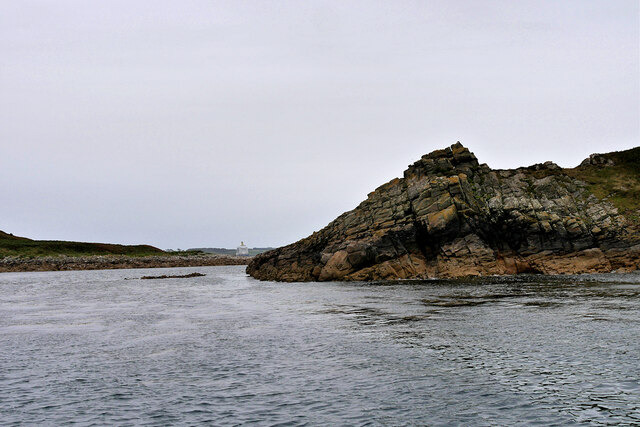
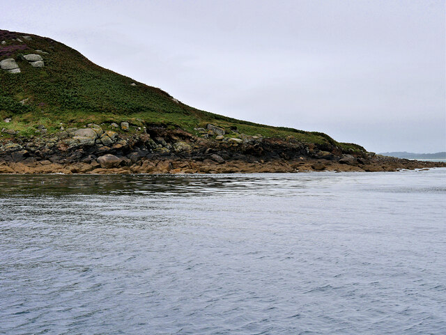
The Outer Rock of Carn Wethers is a small island located off the coast of Cornwall, England. It is situated in the Celtic Sea, approximately 3 kilometers west of the mainland. The island is part of a group of rocks known as the Carn Wethers Rocks, which are renowned for their rugged and rocky terrain.

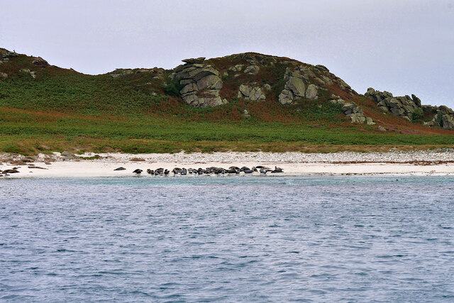
The Outer Rock is a solitary, uninhabited island that measures about 100 meters in diameter. It is predominantly made up of granite, which is characteristic of the geological composition of the area. The island rises steeply from the sea, with cliffs reaching heights of up to 20 meters. These cliffs provide nesting sites for various seabirds, including cormorants and gulls.

Access to the Outer Rock is challenging due to its remote location and treacherous waters. The island is only accessible by boat, and the strong currents and rocky coastline make landing difficult. Consequently, the Outer Rock is largely untouched and remains a natural habitat for wildlife.

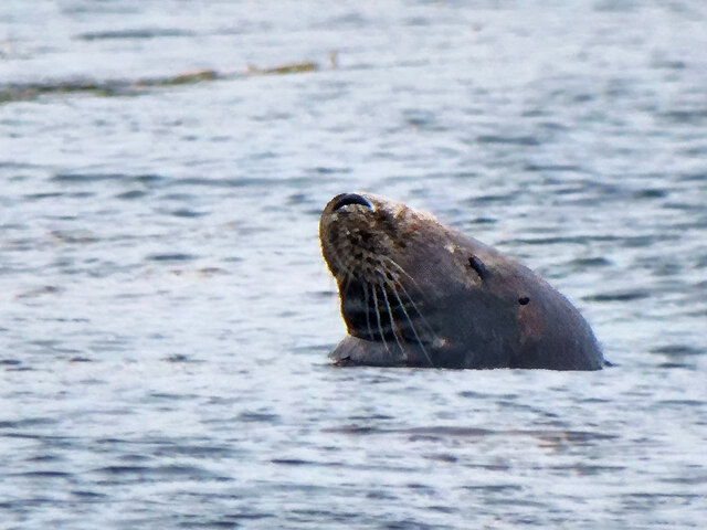
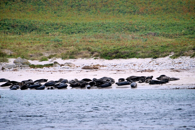
The surrounding waters of the Outer Rock are known for their rich marine biodiversity. The area is popular among divers and snorkelers, who come to explore the underwater caves and observe the diverse array of marine life, including colorful fish, crabs, and lobsters.

Overall, the Outer Rock of Carn Wethers is a picturesque and ecologically significant island off the coast of Cornwall. Its rugged beauty, diverse wildlife, and challenging accessibility make it a popular destination for nature enthusiasts and adventurers alike.

If you have any feedback on the listing, please let us know in the comments section below.

Outer Rock of Carn Wethers Images

Images are sourced within 2km of 49.963752/-6.2603398 or Grid Reference SV9415. Thanks to Geograph Open Source API. All images are credited.

Trig pillar
Trig pillar
A track on eastern St Martin’s The track runs uphill from the eastern end of Higher Town Bay to the Chapel Down and the Daymark.
A track on eastern St Martin’s
The track runs uphill from the eastern end of Higher Town Bay to the Chapel Down and the Daymark.
The Daymark From within the ruins of the Admiralty signal station of  1805.

The signal station is included in the Scheduled Monument comprising the whole of Chapel down and is described thus:

In 1804, an Admiralty signal station was built on northern Chapel Down to communicate with naval vessels by signal mast and to report on enemy shipping movements. It was decommissioned in 1815, superseded by semaphore operated from St Mary's. Its main building stands to 2.3m high in the north of a subrectangular enclosure 38m long, NNW-SSE, by up to 21m wide.

List Entry Number:1016508  <span class="nowrap"><a title="https://historicengland.org.uk/listing/the-list/list-entry/1016508?section=official-list-entry" rel="nofollow ugc noopener" href="https://historicengland.org.uk/listing/the-list/list-entry/1016508?section=official-list-entry">Link</a><img style="margin-left:2px;" alt="External link" title="External link - shift click to open in new window" src="https://s1.geograph.org.uk/img/external.png" width="10" height="10"/></span>

The Daymark is separately listed Grade II*

List Entry Number:1141204 <span class="nowrap"><a title="https://historicengland.org.uk/listing/the-list/list-entry/1141204?section=official-list-entry" rel="nofollow ugc noopener" href="https://historicengland.org.uk/listing/the-list/list-entry/1141204?section=official-list-entry">Link</a><img style="margin-left:2px;" alt="External link" title="External link - shift click to open in new window" src="https://s1.geograph.org.uk/img/external.png" width="10" height="10"/></span>
The Daymark
From within the ruins of the Admiralty signal station of 1805. The signal station is included in the Scheduled Monument comprising the whole of Chapel down and is described thus: In 1804, an Admiralty signal station was built on northern Chapel Down to communicate with naval vessels by signal mast and to report on enemy shipping movements. It was decommissioned in 1815, superseded by semaphore operated from St Mary's. Its main building stands to 2.3m high in the north of a subrectangular enclosure 38m long, NNW-SSE, by up to 21m wide. List Entry Number:1016508 LinkExternal link The Daymark is separately listed Grade II* List Entry Number:1141204 LinkExternal link
Great Bay panorama On of the most beautiful spots on the islands.
Great Bay panorama
On of the most beautiful spots on the islands.
Middle Arthur, Arthur Quay Great, Middle and Little Arthur are three of the Eastern Isles, a group of twelve small uninhabited islands within the Isles of Scilly Area of Outstanding Natural Beauty. Great Arthur, as its name suggests, is the largest of the three.

The three rocky islands are joined by two beaches forming a crescent around Arthur Porth.
Middle Arthur, Arthur Quay
Great, Middle and Little Arthur are three of the Eastern Isles, a group of twelve small uninhabited islands within the Isles of Scilly Area of Outstanding Natural Beauty. Great Arthur, as its name suggests, is the largest of the three. The three rocky islands are joined by two beaches forming a crescent around Arthur Porth.
Rocky Shore, Little Ganilly Little Ganilly (Cornish: Goonhyli Bian, little salt water down) lies just to the north of Little Arthur.
Rocky Shore, Little Ganilly
Little Ganilly (Cornish: Goonhyli Bian, little salt water down) lies just to the north of Little Arthur.
Great Ganilly, West Porth Great Ganilly (Cornish: Goonhyli Meur) is the largest of the Eastern Isles and consists of two hills joined together by a low sandy neck.
Great Ganilly, West Porth
Great Ganilly (Cornish: Goonhyli Meur) is the largest of the Eastern Isles and consists of two hills joined together by a low sandy neck.
Isles of Scilly, Nornour Nornour (Cornish: Ar No) consists of one hill covered in bracken. It lies to the north of Great Ganilly to which it is joined by a boulder causeway at low tide. There is a small area of heath on the hill with heather and bell heather.
Isles of Scilly, Nornour
Nornour (Cornish: Ar No) consists of one hill covered in bracken. It lies to the north of Great Ganilly to which it is joined by a boulder causeway at low tide. There is a small area of heath on the hill with heather and bell heather.
Rocky Ledge between Nornour and Great Ganilly Nornour (Cornish: Ar No) consists of one hill covered in bracken. It is connected to Great Ganilly by a boulder causeway during low tide. The pyramidal island in the background is Hanjague, which is approximately 1 kilometre away.
Rocky Ledge between Nornour and Great Ganilly
Nornour (Cornish: Ar No) consists of one hill covered in bracken. It is connected to Great Ganilly by a boulder causeway during low tide. The pyramidal island in the background is Hanjague, which is approximately 1 kilometre away.
The Eastern Isles, Nornour Nornour (Cornish: Ar No) consists of one hill covered in bracken. It lies to the north of Great Ganilly and is connected to it by a boulder causeway that is visible only during low tide. There is a small area of heath on the hill with heather and bell heather.
The Eastern Isles, Nornour
Nornour (Cornish: Ar No) consists of one hill covered in bracken. It lies to the north of Great Ganilly and is connected to it by a boulder causeway that is visible only during low tide. There is a small area of heath on the hill with heather and bell heather.
Isles of Scilly, Nornour Nornour (Cornish: Ar No) consists of one hill covered in bracken. It lies to the north of Great Ganilly to which it is joined by a boulder causeway at low tide.
Isles of Scilly, Nornour
Nornour (Cornish: Ar No) consists of one hill covered in bracken. It lies to the north of Great Ganilly to which it is joined by a boulder causeway at low tide.
Rocks on the North Coast of Nornour The Eastern Isles (Cornish: Enesow Goonhyli) are a group of twelve small uninhabited islands  located to the south–east of St Martin's. The islands lie within the Isles of Scilly Area of Outstanding Natural Beauty, part of the Scilly Heritage Coast and a Site of Special Scientific Interest (SSSI) first designated in 1971 for its flora and fauna (<span class="nowrap"><a title="https://en.wikipedia.org/wiki/Eastern_Isles" rel="nofollow ugc noopener" href="https://en.wikipedia.org/wiki/Eastern_Isles">Link</a><img style="margin-left:2px;" alt="External link" title="External link - shift click to open in new window" src="https://s1.geograph.org.uk/img/external.png" width="10" height="10"/></span> Wikipedia).
Rocks on the North Coast of Nornour
The Eastern Isles (Cornish: Enesow Goonhyli) are a group of twelve small uninhabited islands located to the south–east of St Martin's. The islands lie within the Isles of Scilly Area of Outstanding Natural Beauty, part of the Scilly Heritage Coast and a Site of Special Scientific Interest (SSSI) first designated in 1971 for its flora and fauna (LinkExternal link Wikipedia).
Isles of Scilly, Nornour The Eastern Isles (Cornish: Enesow Goonhyli) are a group of twelve small uninhabited islands  located to the south–east of St Martin's. The islands lie within the Isles of Scilly Area of Outstanding Natural Beauty, part of the Scilly Heritage Coast and a Site of Special Scientific Interest (SSSI) first designated in 1971 for its flora and fauna (<span class="nowrap"><a title="https://en.wikipedia.org/wiki/Eastern_Isles" rel="nofollow ugc noopener" href="https://en.wikipedia.org/wiki/Eastern_Isles">Link</a><img style="margin-left:2px;" alt="External link" title="External link - shift click to open in new window" src="https://s1.geograph.org.uk/img/external.png" width="10" height="10"/></span> Wikipedia).
Isles of Scilly, Nornour
The Eastern Isles (Cornish: Enesow Goonhyli) are a group of twelve small uninhabited islands located to the south–east of St Martin's. The islands lie within the Isles of Scilly Area of Outstanding Natural Beauty, part of the Scilly Heritage Coast and a Site of Special Scientific Interest (SSSI) first designated in 1971 for its flora and fauna (LinkExternal link Wikipedia).
Isles of Scilly Eastern Isles Looking through the gap between Nornour (on the right) and Great Ganilly.
Isles of Scilly Eastern Isles
Looking through the gap between Nornour (on the right) and Great Ganilly.
Seal Swimming in the Sea off Great Ganilly The Eastern Scilly Isles are one of three main grey seal (Halichoerus grypus) pupping areas.
Seal Swimming in the Sea off Great Ganilly
The Eastern Scilly Isles are one of three main grey seal (Halichoerus grypus) pupping areas.
Great Ganilly, Eastern Scilly Isles Great Ganilly (Cornish: Goonhyli Meur) is the largest of the Eastern Isles and consists of two hills joined together by a low sandy neck.
Great Ganilly, Eastern Scilly Isles
Great Ganilly (Cornish: Goonhyli Meur) is the largest of the Eastern Isles and consists of two hills joined together by a low sandy neck.
Grey Seals on the Beach at East Porth (Great Ganilly) The Eastern Scilly Isles are one of three main grey seal (Halichoerus grypus) pupping areas.
Grey Seals on the Beach at East Porth (Great Ganilly)
The Eastern Scilly Isles are one of three main grey seal (Halichoerus grypus) pupping areas.
Great Ganilly, East Porth The Eastern Scilly Isles are one of three main grey seal (Halichoerus grypus) pupping areas.
Great Ganilly, East Porth
The Eastern Scilly Isles are one of three main grey seal (Halichoerus grypus) pupping areas.
Show me another place!

Outer Rock of Carn Wethers is located at Grid Ref: SV9415 (Lat: 49.963752, Lng: -6.2603398)

Division: Isles of Scilly

Unitary Authority: Isles of Scilly

Police Authority: Devon and Cornwall

What 3 Words

///shuttered.forms.idealist. Near St Martin's, Isles of Scilly

Related Wikis

PS Earl of Arran (1860)

PS Earl of Arran was a passenger vessel operated by the Ardrossan Steamboat Company from 1860 to 1871 and the West Cornwall Steam Ship Company from 1871...

Great Ganilly

Great Ganilly ( gə-NIL-ee; Cornish: Goonhyli Veur, lit. 'great saltwater downs') is one of the Eastern Isles of the Isles of Scilly. It has a maximum total...

Eastern Isles

The Eastern Isles (Cornish: Enesow Goonhyli, islands of the salt water downs) are a group of twelve small uninhabited islands within the Isles of Scilly...

Higher Town, Isles of Scilly

Higher Town (Cornish: Trewartha) is the easternmost and largest settlement on the island of St Martin's in the Isles of Scilly, England. It is situated...

Nearby Amenities

Located within 500m of 49.963752,-6.2603398
Chapel Down
Place: locality
Lat/Long: 49.9645213/-6.2651179
Mullet Pool
Natural: bay
Lat/Long: 49.9635851/-6.2610873
Northward Bight
Natural: bay
Lat/Long: 49.9655865/-6.2622675
Southward Bight
Natural: bay
Lat/Long: 49.9649309/-6.2616345
Brandy Point
Place: locality
Lat/Long: 49.9611626/-6.2656148
Pope's Hole
Natural: cave_entrance
Lat/Long: 49.964402/-6.2624195
The data included in this document is from www.openstreetmap.org. The data is made available under ODbL.

Have you been to Outer Rock of Carn Wethers?

Leave your review of Outer Rock of Carn Wethers below (or comments, questions and feedback).