Black Loch

Lake, Pool, Pond, Freshwater Marsh in Wigtownshire

Scotland

Black Loch

Fodder crop at West Glengyre Or perhaps it will be ploughed in; possibly a brassica. With Gorse on the hilltop.
Fodder crop at West Glengyre Credit: M J Richardson

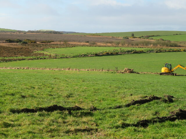
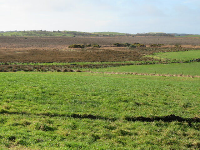
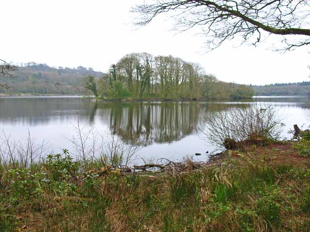
Black Loch is a picturesque freshwater loch located in Wigtownshire, Scotland. Nestled amidst the beautiful countryside, this natural water body is a popular destination for nature enthusiasts and anglers alike. Covering an area of approximately 80 acres, it offers a serene and tranquil atmosphere for visitors to enjoy.

Surrounded by lush greenery and rolling hills, Black Loch is known for its diverse ecosystem. The loch is home to a variety of freshwater fish species, including pike, perch, roach, and eels, making it a prime spot for fishing enthusiasts. Anglers can often be seen casting their lines from the shores, hoping to reel in a prized catch.

The surrounding area of Black Loch is adorned with vibrant flora and fauna, creating an idyllic environment for wildlife to thrive. Birdwatchers flock to the loch to observe an array of bird species, including swans, ducks, herons, and even the occasional osprey. The marshy areas around the loch provide a habitat for various waterfowl and marshland plants.

Visitors to Black Loch can enjoy a range of recreational activities. The calm waters of the loch are ideal for boating and canoeing, allowing visitors to explore its beauty from a different perspective. Walking trails around the loch offer an opportunity for leisurely strolls while soaking up the surrounding natural beauty.

Overall, Black Loch is a haven for nature lovers seeking a peaceful retreat. Its diverse wildlife, scenic beauty, and recreational opportunities make it a cherished destination for locals and tourists alike.

If you have any feedback on the listing, please let us know in the comments section below.

Black Loch Images

Images are sourced within 2km of 54.92647/-5.1201872 or Grid Reference NX0063. Thanks to Geograph Open Source API. All images are credited.

Fodder crop at West Glengyre Or perhaps it will be ploughed in; possibly a brassica. With Gorse on the hilltop.
Fodder crop at West Glengyre
Or perhaps it will be ploughed in; possibly a brassica. With Gorse on the hilltop.
West Glengyre A farm west of Leswalt.
West Glengyre
A farm west of Leswalt.
Pasture at West Glengyre Somewhat 'poached' in places.
Pasture at West Glengyre
Somewhat 'poached' in places.
Garchrie Moss Here mosses are bogs, and this is probably a raised bog. Looking southwest from High Weirston.
Garchrie Moss
Here mosses are bogs, and this is probably a raised bog. Looking southwest from High Weirston.
Garchrie Moss Here mosses are bogs, and this is probably a raised bog. Looking southwest from High Weirston.
Garchrie Moss
Here mosses are bogs, and this is probably a raised bog. Looking southwest from High Weirston.
Farm buildings at Glengyre And signpost - Leswalt 2.
Farm buildings at Glengyre
And signpost - Leswalt 2.
Flying the flag at Glenerskay The Saltire flutters at Glengyre.
Flying the flag at Glenerskay
The Saltire flutters at Glengyre.
New bungalow near Lochnaw Castle
Loch Naw An 11th century castle once stood on the island in the middle of the loch. The current 16th century Lochnaw Castle, ancestral home of the Agnew clan, lies directly beyond the island on the far shore.
Loch Naw
An 11th century castle once stood on the island in the middle of the loch. The current 16th century Lochnaw Castle, ancestral home of the Agnew clan, lies directly beyond the island on the far shore.
Farm and driveway near Lochnaw Castle
Entrance to Drumlochart Caravan Park The caravan park is set in attractive surroundings near Lochnaw Castle. <span class="nowrap"><a title="http://www.drumlochart.co.uk/" rel="nofollow ugc noopener" href="http://www.drumlochart.co.uk/">Link</a><img style="margin-left:2px;" alt="External link" title="External link - shift click to open in new window" src="https://s1.geograph.org.uk/img/external.png" width="10" height="10"/></span>
Entrance to Drumlochart Caravan Park
The caravan park is set in attractive surroundings near Lochnaw Castle. LinkExternal link
Lochnaw Castle Lochnaw Castle (in the pouring rain), home (once upon a time) of the Agnew family.  The oldest bit is the tall tower, which is 16th century.  It was an hotel for a while, but had stopped being so when I arrived there to stay recently!  It is now a private home again (with a very long and muddy drive!).
Lochnaw Castle
Lochnaw Castle (in the pouring rain), home (once upon a time) of the Agnew family. The oldest bit is the tall tower, which is 16th century. It was an hotel for a while, but had stopped being so when I arrived there to stay recently! It is now a private home again (with a very long and muddy drive!).
Recycling, The Rhins
Glengyre Farm, The Rhins
Locknaw Castle Picture taken during restoration
Locknaw Castle
Picture taken during restoration
Garchrie Moss An area of low moorland to the west of Leswalt. The coniferous woodland is an extension of Glenlochart Wood.
Garchrie Moss
An area of low moorland to the west of Leswalt. The coniferous woodland is an extension of Glenlochart Wood.
Lochnaw Loch Looking across a large raft of aquatic vegetation towards Lochnaw Castle on the far shore.
Lochnaw Loch
Looking across a large raft of aquatic vegetation towards Lochnaw Castle on the far shore.
Junction of  B roads This is the junction of the B738 and the B7043.
Junction of B roads
This is the junction of the B738 and the B7043.
Show me another place!

Black Loch is located at Grid Ref: NX0063 (Lat: 54.92647, Lng: -5.1201872)

Unitary Authority: Dumfries and Galloway

Police Authority: Dumfries and Galloway

What 3 Words

///tidy.otter.autumn. Near Stranraer, Dumfries & Galloway

Related Wikis

Leswalt

Leswalt (Scottish Gaelic: Lios Uillt) is a village and civil parish in Dumfries and Galloway, south-west Scotland. It lies between Portpatrick and Stranraer...
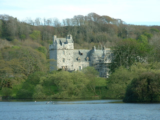
Galdenoch Castle

Galdenoch Castle is a tower house near the Scottish village of Leswalt in the Council Area Dumfries and Galloway . The ruin is listed as a Scheduled Monument...

Ervie

Ervie is a small village in Dumfries and Galloway, Scotland, in the Rhins of Galloway, just outside Stranraer.

RAF Wig Bay

Royal Air Force Wig Bay, or more simply RAF Wig Bay, is a former Royal Air Force station near Stranraer, Dumfries and Galloway, Scotland The following...

Kirkcolm

Kirkcolm (Scots: Kirkcoam) is a village and civil parish on the northern tip of the Rhinns of Galloway peninsula, south-west Scotland. It is in Dumfries...

Old Town Hall, Stranraer

The Old Town Hall is a municipal structure in George Street, Stranraer, Dumfries and Galloway, Scotland. The structure, which is used as a local history...

Stranraer railway station

Stranraer railway station (formerly known as Stranraer Harbour railway station) is a railway station that serves the town of Stranraer, Dumfries and Galloway...

Stranraer Sheriff Court

Stranraer Sheriff Court is a judicial building in Lewis Street, Stranraer, Dumfries and Galloway, Scotland. The building, which continues to be used as...

Nearby Amenities

Located within 500m of 54.92647,-5.1201872
Glenhead of Aldouran
Place: farm
Lat/Long: 54.9280625/-5.1149161
Power: pole
Lat/Long: 54.9250103/-5.1138139
Power: pole
Lat/Long: 54.9256715/-5.1145515
Power: pole
Lat/Long: 54.926345/-5.1152569
Power: pole
Lat/Long: 54.9273576/-5.116244
Power: pole
Lat/Long: 54.9291177/-5.114239
Power: pole
Lat/Long: 54.9286253/-5.1154554
Power: pole
Lat/Long: 54.9281691/-5.1166074
Power: pole
Lat/Long: 54.9280651/-5.1168622
Generator Method: wind_turbine
Generator Source: wind
Generator Type: horizontal_axis
Power: generator
Lat/Long: 54.9291578/-5.1178104
Power: pole
Lat/Long: 54.9306018/-5.1179016
Power: pole
Lat/Long: 54.9301441/-5.1171666
Power: pole
Lat/Long: 54.9294151/-5.116877
Power: pole
Lat/Long: 54.9287093/-5.1166034
Power: pole
Lat/Long: 54.9279972/-5.1163298
Power: pole
Lat/Long: 54.9272189/-5.1157343
Power: pole
Lat/Long: 54.9264036/-5.1151443
Power: pole
Lat/Long: 54.9258087/-5.1144871
Power: pole
Lat/Long: 54.9251999/-5.1138487
Turning Loop
Lat/Long: 54.925896/-5.1253542
Turning Loop
Lat/Long: 54.9249149/-5.1262481
Caravans: yes
Tourism: camp_pitch
Lat/Long: 54.9247309/-5.1260879
Caravans: yes
Tourism: camp_pitch
Lat/Long: 54.9246002/-5.1259064
Caravans: yes
Tourism: camp_pitch
Lat/Long: 54.9246707/-5.1259048
Caravans: yes
Tourism: camp_pitch
Lat/Long: 54.9245223/-5.1259342
Caravans: yes
Tourism: camp_pitch
Lat/Long: 54.9247309/-5.1258966
Caravans: yes
Tourism: camp_pitch
Lat/Long: 54.9248192/-5.125926
Caravans: yes
Tourism: camp_pitch
Lat/Long: 54.9249272/-5.1257952
Caravans: yes
Tourism: camp_pitch
Lat/Long: 54.9249629/-5.1256202
Caravans: yes
Tourism: camp_pitch
Lat/Long: 54.9249047/-5.1255107
Caravans: yes
Tourism: camp_pitch
Lat/Long: 54.9248088/-5.125599
Caravans: yes
Tourism: camp_pitch
Lat/Long: 54.9247243/-5.1257004
Caravans: yes
Tourism: camp_pitch
Lat/Long: 54.9246407/-5.1257772
Caravans: yes
Tourism: camp_pitch
Lat/Long: 54.9244386/-5.1257576
Caravans: yes
Tourism: camp_pitch
Lat/Long: 54.9244941/-5.1256856
Caravans: yes
Tourism: camp_pitch
Lat/Long: 54.9245589/-5.1256382
Caravans: yes
Tourism: camp_pitch
Lat/Long: 54.9246078/-5.1255777
Caravans: yes
Tourism: camp_pitch
Lat/Long: 54.9247581/-5.1254371
Caravans: yes
Tourism: camp_pitch
Lat/Long: 54.9246886/-5.1255156
Caravans: yes
Tourism: camp_pitch
Lat/Long: 54.9248276/-5.1253537
Caravans: yes
Tourism: camp_pitch
Lat/Long: 54.9248915/-5.1252687
Caravans: yes
Tourism: camp_pitch
Lat/Long: 54.9249498/-5.1251967
Caravans: yes
Tourism: camp_pitch
Lat/Long: 54.9251114/-5.1254698
Caravans: yes
Tourism: camp_pitch
Lat/Long: 54.9251969/-5.1253521
Caravans: yes
Tourism: camp_pitch
Lat/Long: 54.925273/-5.1252605
Caravans: yes
Tourism: camp_pitch
Lat/Long: 54.9253576/-5.1251346
Caravans: yes
Tourism: camp_pitch
Lat/Long: 54.9252655/-5.1250757
Caravans: yes
Tourism: camp_pitch
Lat/Long: 54.92518/-5.1251755
Caravans: yes
Tourism: camp_pitch
Lat/Long: 54.925102/-5.1252556
Caravans: yes
Tourism: camp_pitch
Lat/Long: 54.9250325/-5.1253488
Caravans: yes
Tourism: camp_pitch
Lat/Long: 54.9253209/-5.124873
The data included in this document is from www.openstreetmap.org. The data is made available under ODbL.

Have you been to Black Loch?

Leave your review of Black Loch below (or comments, questions and feedback).