Kneefill Ness

Coastal Feature, Headland, Point in Shetland

Scotland

Kneefill Ness

Qui Ness The grassy headland of Qui Ness can be reached by a narrow, well-worn but rather exposed path over a little neck of land - the sheep and lamb seen in this view have just ventured across to reach the extensive patch of grazing beyond. Either side are two deep geos, both with small stacks within them. The nearer one has a beach and is probably not eroding the link, but the more easterly one will no doubt extend by headward erosion and cut the Ness off to form an island in the near future (by geological time standards). To the right of the photo, Tame Holm has similarly been separated from its headland, West Ness, by a narrow channel of the sort much enjoyed by sea kayakers.

In the distance, the far horizon is formed by Esha Ness and Ronas Hill, whilst the nearer grey cliffs in the centre of the view are the Ness of Hillswick with the dramatic stacks of the Drongs just visible to its west.
Qui Ness Credit: Andy Waddington

Kneefill Ness is a prominent coastal feature located in the Shetland Islands, situated off the northeastern coast of Scotland. It is classified as a headland or a point, depending on the specific definition used.

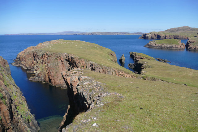
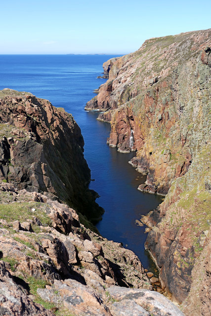
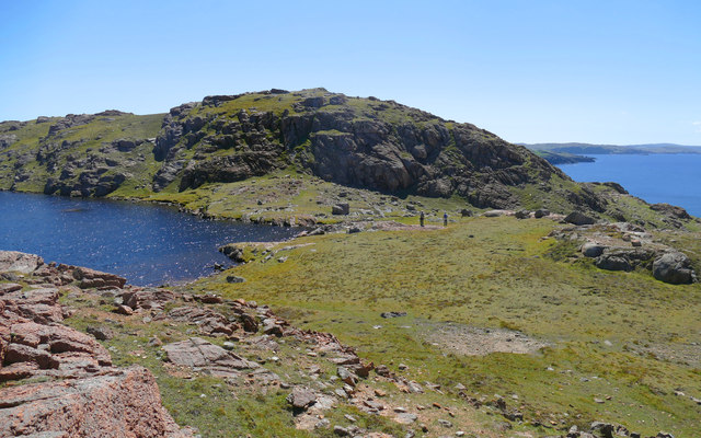
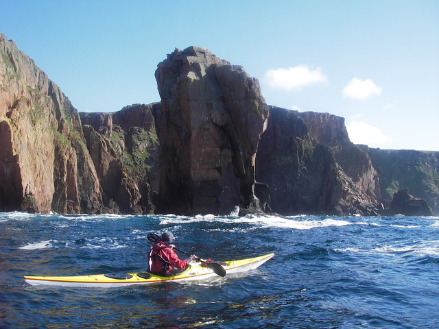
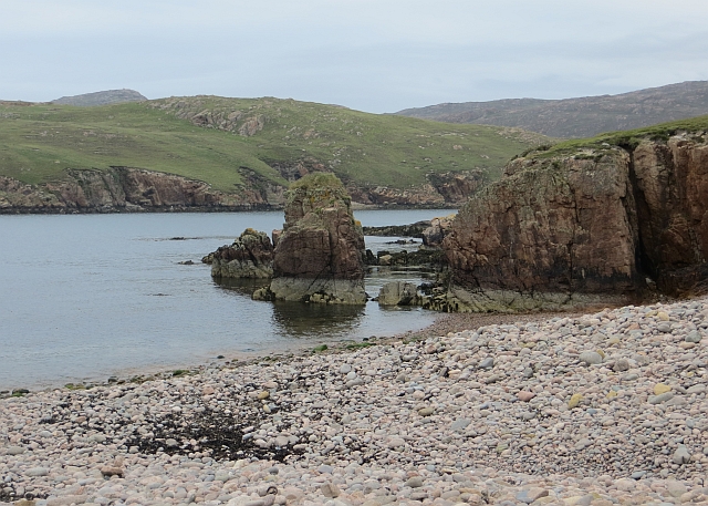
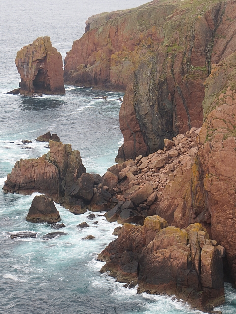
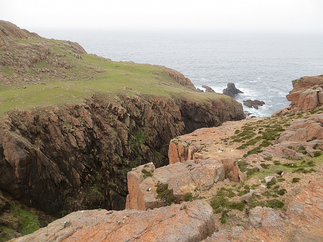
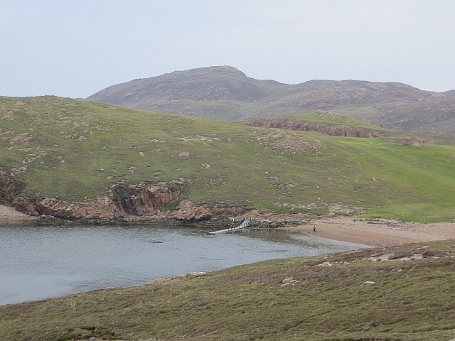
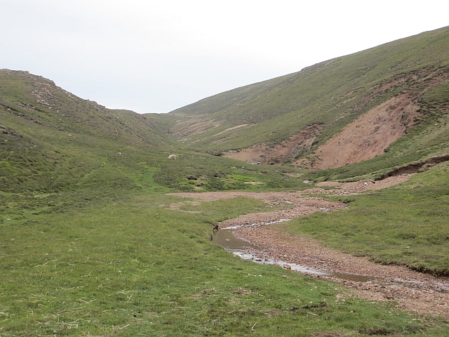
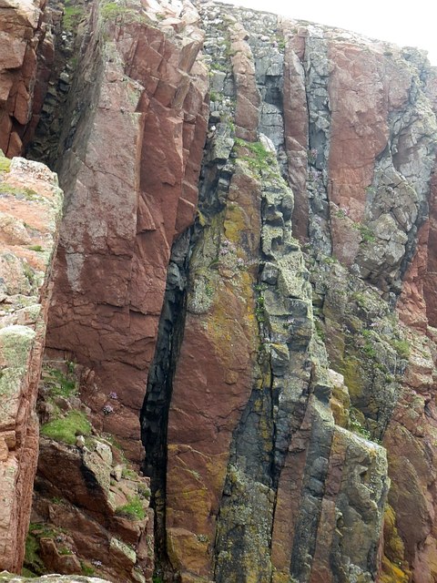
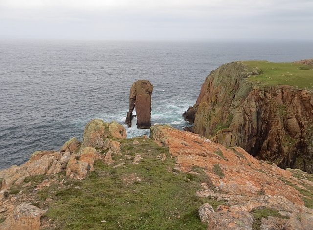
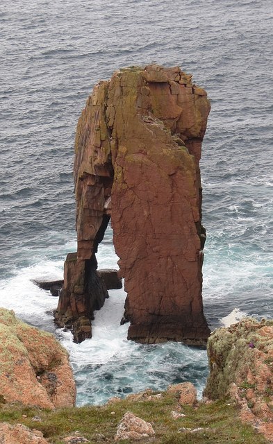
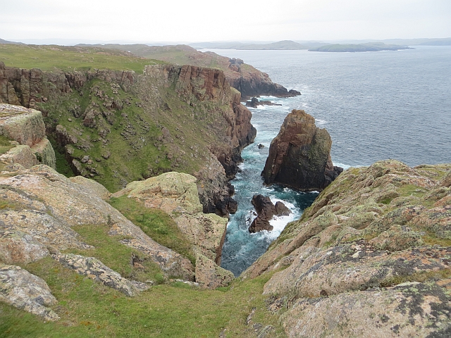
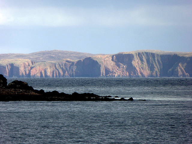
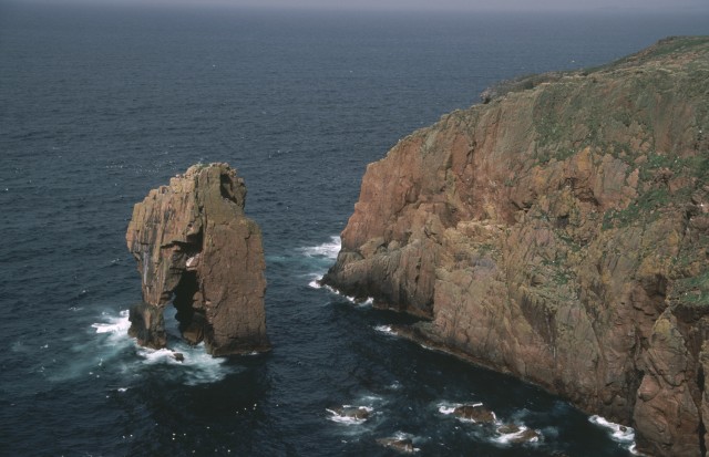
Rising proudly from the surrounding landscape, Kneefill Ness boasts impressive cliffs that overlook the North Atlantic Ocean. The headland is characterized by its rugged and dramatic terrain, with steep slopes and jagged rocks that have been shaped by centuries of wind and waves. The cliffs offer breathtaking panoramic views of the surrounding coastline, making it a popular spot for sightseeing and photography.

The area surrounding Kneefill Ness is rich in wildlife, with numerous bird species making their homes on the cliffs. Visitors may have the chance to spot seabirds such as puffins, guillemots, and gannets, as well as occasional sightings of seals and porpoises in the waters below.

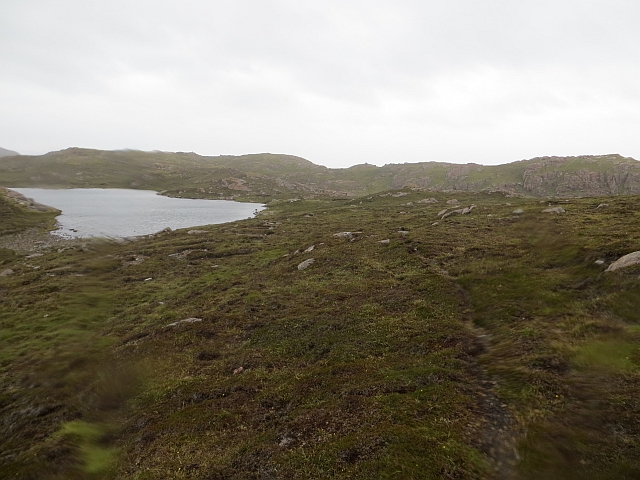
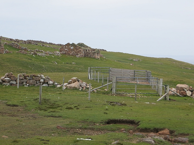
Access to Kneefill Ness is relatively easy, with a well-maintained coastal path leading visitors to the headland. The path offers stunning views along the way, showcasing the rugged beauty of the Shetland coastline.

Due to its exposed location, Kneefill Ness is subject to strong winds and rough seas, particularly during storms. Visitors are advised to take caution and adhere to safety guidelines when exploring the headland.

Overall, Kneefill Ness is a captivating coastal feature that showcases the raw beauty and untamed nature of the Shetland Islands. Its dramatic cliffs, diverse wildlife, and stunning views make it a must-visit destination for nature enthusiasts and explorers.

If you have any feedback on the listing, please let us know in the comments section below.

Kneefill Ness Images

Images are sourced within 2km of 60.371496/-1.4729392 or Grid Reference HU2965. Thanks to Geograph Open Source API. All images are credited.

Qui Ness The grassy headland of Qui Ness can be reached by a narrow, well-worn but rather exposed path over a little neck of land - the sheep and lamb seen in this view have just ventured across to reach the extensive patch of grazing beyond. Either side are two deep geos, both with small stacks within them. The nearer one has a beach and is probably not eroding the link, but the more easterly one will no doubt extend by headward erosion and cut the Ness off to form an island in the near future (by geological time standards). To the right of the photo, Tame Holm has similarly been separated from its headland, West Ness, by a narrow channel of the sort much enjoyed by sea kayakers.

In the distance, the far horizon is formed by Esha Ness and Ronas Hill, whilst the nearer grey cliffs in the centre of the view are the Ness of Hillswick with the dramatic stacks of the Drongs just visible to its west.
Qui Ness
The grassy headland of Qui Ness can be reached by a narrow, well-worn but rather exposed path over a little neck of land - the sheep and lamb seen in this view have just ventured across to reach the extensive patch of grazing beyond. Either side are two deep geos, both with small stacks within them. The nearer one has a beach and is probably not eroding the link, but the more easterly one will no doubt extend by headward erosion and cut the Ness off to form an island in the near future (by geological time standards). To the right of the photo, Tame Holm has similarly been separated from its headland, West Ness, by a narrow channel of the sort much enjoyed by sea kayakers. In the distance, the far horizon is formed by Esha Ness and Ronas Hill, whilst the nearer grey cliffs in the centre of the view are the Ness of Hillswick with the dramatic stacks of the Drongs just visible to its west.
Dandi Geo Muckle Roe is formed entirely of igneous rocks forming a pluton of Old Red Sandstone (Devonian) age, and all except the NE side are a Granophyre which forms dramatic red cliffs riven by geos, caves and natural arches. Dandi Geo is one of the narrower geos eroded from the west coast of the island just at the point where a small stream drains northwestwards from a series of small lochans. In the far distance, Esha Ness can be seen across St. Magnus Bay, itself a large basin possibly associated with an ancient meteorite impact.
Dandi Geo
Muckle Roe is formed entirely of igneous rocks forming a pluton of Old Red Sandstone (Devonian) age, and all except the NE side are a Granophyre which forms dramatic red cliffs riven by geos, caves and natural arches. Dandi Geo is one of the narrower geos eroded from the west coast of the island just at the point where a small stream drains northwestwards from a series of small lochans. In the far distance, Esha Ness can be seen across St. Magnus Bay, itself a large basin possibly associated with an ancient meteorite impact.
Crossing the outlet of Loch of Rusness Apart from needing to detour inland to avoid deep geos, the southwest coast of Muckle Roe offers easy walking terrain with short grass on the shallow soil formed by the disintegration of the hard granophyre into coarse sand. Paths materialise and evaporate from time to time as the terrain constrains the route, such as at the crossing point of the small stream draining Loch of Rusness. Two paths are apparent on the far side, one contouring nearer the cliffs on the right, and one diagonalling up the far side of the lochan. The latter was the one we chose, and it duly evaporated within a hundred metres.
Crossing the outlet of Loch of Rusness
Apart from needing to detour inland to avoid deep geos, the southwest coast of Muckle Roe offers easy walking terrain with short grass on the shallow soil formed by the disintegration of the hard granophyre into coarse sand. Paths materialise and evaporate from time to time as the terrain constrains the route, such as at the crossing point of the small stream draining Loch of Rusness. Two paths are apparent on the far side, one contouring nearer the cliffs on the right, and one diagonalling up the far side of the lochan. The latter was the one we chose, and it duly evaporated within a hundred metres.
Beach, South Ham A sheltered inlet on the otherwise rugged coast of Muckle Roe. It is also popular with seals.
Beach, South Ham
A sheltered inlet on the otherwise rugged coast of Muckle Roe. It is also popular with seals.
Fresh rockfall, Muckle Roe A pile of boulders beneath a clean bit of rock seen across Gulberswick Geo.
Fresh rockfall, Muckle Roe
A pile of boulders beneath a clean bit of rock seen across Gulberswick Geo.
Dandi Geo A long and deep inlet in the sea cliffs of Muckle Roe.
Dandi Geo
A long and deep inlet in the sea cliffs of Muckle Roe.
Moorland by Loch of Rusness A fine and bright morning had rapidly turned to heavy rain in the afternoon. The usual crisp and gravelly Muckle Roe moorland.
Moorland by Loch of Rusness
A fine and bright morning had rapidly turned to heavy rain in the afternoon. The usual crisp and gravelly Muckle Roe moorland.
Beach, South Ham The wild coast of Muckle Roe.
Beach, South Ham
The wild coast of Muckle Roe.
Burn of Lairdsloch Granite scenery, Muckle Roe.
Burn of Lairdsloch
Granite scenery, Muckle Roe.
Burg Ruined croft house on the west coast of Muckle Roe.
Burg
Ruined croft house on the west coast of Muckle Roe.
Dykes near Burg Pink and black stripes due to volcanic activity (related to the rocks on Papa Stour and Esha Ness?). The even weathering is striking, often the basalt stands proud or forms gullies depending on the country rock.
Dykes near Burg
Pink and black stripes due to volcanic activity (related to the rocks on Papa Stour and Esha Ness?). The even weathering is striking, often the basalt stands proud or forms gullies depending on the country rock.
Da Kist A two legged stack near Burg, Muckle Roe. The coast of Muckle Roe has examples of all the stages of coastal erosion on display. This is a stack nearing collapse or at least partial collapse.
Da Kist
A two legged stack near Burg, Muckle Roe. The coast of Muckle Roe has examples of all the stages of coastal erosion on display. This is a stack nearing collapse or at least partial collapse.
Da Kist Sooner or later there will be one wave too many for the "leg".
Da Kist
Sooner or later there will be one wave too many for the "leg".
Spindle Granite stack on the west coast of Muckle Roe.
Spindle
Granite stack on the west coast of Muckle Roe.
West Hill of Ham Hill with some big sea cliffs.
West Hill of Ham
Hill with some big sea cliffs.
Muckle Roe Viewed from Melby.
Muckle Roe
Viewed from Melby.
Sea Stack "Da Kist" The coastline within this square contains a number of cliffs and sea stacks.  Most are somewhat loose and unsuitable for climbing, but the stack in this photo now has a route on the landward side facing away from this shot.
Sea Stack "Da Kist"
The coastline within this square contains a number of cliffs and sea stacks. Most are somewhat loose and unsuitable for climbing, but the stack in this photo now has a route on the landward side facing away from this shot.
Show me another place!

Kneefill Ness is located at Grid Ref: HU2965 (Lat: 60.371496, Lng: -1.4729392)

Unitary Authority: Shetland Islands

Police Authority: Highlands and Islands

What 3 Words

///observes.heartless.undulation. Near Brae, Shetland Islands

Related Wikis

Muckle Roe

Muckle Roe is an island in Shetland, Scotland, in St. Magnus Bay, to the west of Mainland. It has a population of around 130 people, who mainly croft and...

Linga (near Vementry)

Linga is one of the Shetland Islands, near Vementry. It is one of many islands in Shetland called Linga. The island is uninhabited. == Geography and... ==

Vementry

Vementry (Old Norse: "Vemunðarey") is an uninhabited Scottish island in Shetland on the north side of the West Mainland, lying south of Muckle Roe. �...

Mavis Grind

Mavis Grind (Old Norse: Mæfeiðs grind or Mæveiðs grind, meaning "gate of the narrow isthmus") is a narrow isthmus joining the Northmavine peninsula to...

Papa Little

Papa Little (Scots: Papa Little; Old Norse: Papey Litla, meaning "the little island of the priests") is an island in St Magnus Bay, Shetland, Scotland...

Busta Voe

Busta Voe, (HU665350), in the north central Mainland, Shetland, is a sea inlet lying between the village of Brae and the island of Muckle Roe. At the head...

Linga, Busta Voe

Linga is a small, uninhabited island, 1 km (0.62 mi) east of Muckle Roe in the Shetland Islands. The island is roughly circular in shape and its highest...

Brae

"Brae" is also the Lowland Scots language word for the slope or brow of a hill.Brae (Old Norse: Breiðeið, meaning "the wide isthmus") is a village on the...

Nearby Amenities

Located within 500m of 60.371496,-1.4729392
Burg
Place: locality
Lat/Long: 60.3723106/-1.4670282
The data included in this document is from www.openstreetmap.org. The data is made available under ODbL.

Have you been to Kneefill Ness?

Leave your review of Kneefill Ness below (or comments, questions and feedback).