Holborn Head

Coastal Feature, Headland, Point in Caithness

Scotland

Holborn Head

Track to Holbornhead
Track to Holbornhead Credit: Bill Henderson

Holborn Head is a prominent coastal feature located in the county of Caithness, in the far north of Scotland. It is characterized as a dramatic headland that juts out into the North Sea, forming a distinctive point along the Caithness coastline.

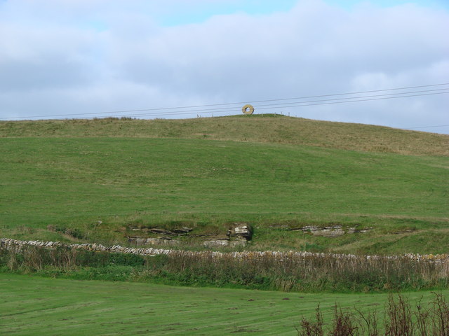
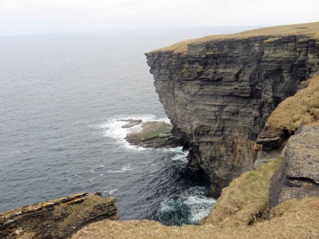
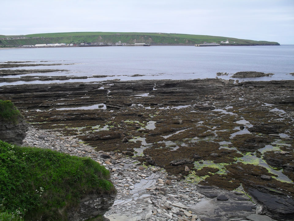
Rising to an elevation of approximately 100 meters (328 feet) above sea level, Holborn Head offers stunning panoramic views of the surrounding area. The headland is formed primarily of rugged cliffs, which are composed of sedimentary rocks such as sandstone and limestone. These cliffs are subject to constant erosion from the powerful waves and winds that batter the coast, resulting in the formation of sea stacks and caves along the shoreline.

The area surrounding Holborn Head is rich in biodiversity, with various species of seabirds, including puffins, guillemots, and kittiwakes, nesting on the cliffs. The headland also provides a habitat for a range of other wildlife, such as seals, which can often be seen basking on the rocks.

Holborn Head is a popular destination for outdoor enthusiasts and nature lovers, attracting visitors who are keen to explore its natural beauty and observe the diverse wildlife. The headland is accessible via a network of walking trails, allowing visitors to enjoy the stunning coastal views while immersing themselves in the tranquility of the surrounding landscape.

Overall, Holborn Head is a captivating coastal feature in Caithness, offering a unique blend of rugged cliffs, diverse wildlife, and breathtaking views that make it a must-visit destination for anyone exploring the region.

If you have any feedback on the listing, please let us know in the comments section below.

Holborn Head Images

Images are sourced within 2km of 58.622095/-3.5376717 or Grid Reference ND1071. Thanks to Geograph Open Source API. All images are credited.

Track to Holbornhead
Bell Mount, Scrabster
Spear Head
Spear Head
Steep slopes above Scrabster Not rocky crags but clay slopes of dubious stability.
Steep slopes above Scrabster
Not rocky crags but clay slopes of dubious stability.
Approaching The A9 This minor road connects with the A9 main road for Scrabster Harbour.
Approaching The A9
This minor road connects with the A9 main road for Scrabster Harbour.
Scrabster Harbour View The beach lies inside this square.  The Northlink ferry is visible in the background, preparing to sail for Orkney.
Scrabster Harbour View
The beach lies inside this square. The Northlink ferry is visible in the background, preparing to sail for Orkney.
Scrabster House, Scrabster, viewed from P&O's Adonia, sailing into Scrabster Harbour According to the Royal Commission on the Ancient and Historical Monuments of Scotland organisation ... 
this fine looking house is, reputedly built on the site of the former Mansion House of the Bishop of Caithness.  
The current house was built about 1850 in the Scottish Baronial Style.
The RCAHMS describe the house as of no architectural significance ... which I think is rather harsh!

See also ...
<a href="https://www.geograph.org.uk/photo/3656277">ND0969 : Scrabster House, Scrabster, viewed from P&O's Adonia, sailing away from Scrabster Harbour</a>
Scrabster House, Scrabster, viewed from P&O's Adonia, sailing into Scrabster Harbour
According to the Royal Commission on the Ancient and Historical Monuments of Scotland organisation ... this fine looking house is, reputedly built on the site of the former Mansion House of the Bishop of Caithness. The current house was built about 1850 in the Scottish Baronial Style. The RCAHMS describe the house as of no architectural significance ... which I think is rather harsh! See also ... ND0969 : Scrabster House, Scrabster, viewed from P&O's Adonia, sailing away from Scrabster Harbour
Scrabster House, Scrabster, viewed from P&O's Adonia, sailing away from Scrabster Harbour According to the Royal Commission on the Ancient and Historical Monuments of Scotland organisation ... 
this fine looking house is, reputedly built on the site of the former Mansion House of the Bishop of Caithness.  
The current house was built about 1850 in the Scottish Baronial Style.
The RCAHMS describe the house as of no architectural significance ... which I think is rather harsh!

See also ...
<a href="https://www.geograph.org.uk/photo/3656273">ND0969 : Scrabster House, Scrabster, viewed from P&O's Adonia, sailing into Scrabster Harbour</a>
Scrabster House, Scrabster, viewed from P&O's Adonia, sailing away from Scrabster Harbour
According to the Royal Commission on the Ancient and Historical Monuments of Scotland organisation ... this fine looking house is, reputedly built on the site of the former Mansion House of the Bishop of Caithness. The current house was built about 1850 in the Scottish Baronial Style. The RCAHMS describe the house as of no architectural significance ... which I think is rather harsh! See also ... ND0969 : Scrabster House, Scrabster, viewed from P&O's Adonia, sailing into Scrabster Harbour
A mooring post in the car park
Clett Terrace, Scrabster, near Thurso Clett Terrace forms part of a small housing development on the clifftop at Scrabster, on the north coast of Scotland.

This image was taken on an April evening. The sun was still shining bright but the shadows were long.
Clett Terrace, Scrabster, near Thurso
Clett Terrace forms part of a small housing development on the clifftop at Scrabster, on the north coast of Scotland. This image was taken on an April evening. The sun was still shining bright but the shadows were long.
Holburn Head Road, Scrabster, near Thurso Holburn Head Road in the small settlement of Scrabster on the north coast of Scotland.  This view looks south-eastwards, across Thurso Bay to the town of Thurso.

This image was taken on an April evening. The sun was still shining bright but the shadows were long.
Holburn Head Road, Scrabster, near Thurso
Holburn Head Road in the small settlement of Scrabster on the north coast of Scotland. This view looks south-eastwards, across Thurso Bay to the town of Thurso. This image was taken on an April evening. The sun was still shining bright but the shadows were long.
St. Clair Avenue, Scrabster, near Thurso St. Clair Avenue forms part of a small housing development on the clifftop at Scrabster, on the north coast of Scotland.

This image was taken on an April evening. The sun was shining but the shadows were long.
St. Clair Avenue, Scrabster, near Thurso
St. Clair Avenue forms part of a small housing development on the clifftop at Scrabster, on the north coast of Scotland. This image was taken on an April evening. The sun was shining but the shadows were long.
A9 entering Scrabster, near Thurso A view of the A9 road as it enters Scrabster, on the north coast of Scotland.  The A9 ends at Scrabster.

This image was taken on an April evening. The sun was still shining bright but the shadows were long.
A9 entering Scrabster, near Thurso
A view of the A9 road as it enters Scrabster, on the north coast of Scotland. The A9 ends at Scrabster. This image was taken on an April evening. The sun was still shining bright but the shadows were long.
Cottage in Scrabster Progress has been made since <a href="https://www.geograph.org.uk/photo/5811362">ND0970 : Cottage at Scrabster</a> five years ago. One of the windows and the grotty caravan have been replaced,  some of the rubbish has gone and the bush has been cut back. And a satellite dish has arrived.
Cottage in Scrabster
Progress has been made since ND0970 : Cottage at Scrabster five years ago. One of the windows and the grotty caravan have been replaced, some of the rubbish has gone and the bush has been cut back. And a satellite dish has arrived.
Scrabster Harbour Viewed from the top of the steps which lead up from the main road.
Scrabster Harbour
Viewed from the top of the steps which lead up from the main road.
Oil Depot, Scrabster
Scrabster Harbour
Scrabster Harbour
Old cottage, Scrabster Harbour
Show me another place!

Holborn Head is located at Grid Ref: ND1071 (Lat: 58.622095, Lng: -3.5376717)

Unitary Authority: Highland

Police Authority: Highlands and Islands

What 3 Words

///stick.report.escalates. Near Thurso, Highland

Related Wikis

Clett

Clett is a name used for many uninhabited Scottish islets and one to the south, though also in the area inhabited by Vikings. They include - One at 58...

Thurso Bay

Thurso Bay, known also as Scrabster Bay, is a bay of Atlantic water between the points of Clairdon Head and Holborn Head on the north coast of Caithness...

Scrabster

Scrabster (Scots: Scraibster, Scottish Gaelic: Sgrabastair/Sgrabstal) is a small settlement on Thurso Bay in Caithness on the north coast of Scotland....

Burnside, Highland

Burnside is a predominantly residential area of Thurso, Caithness, in the Highland council area of Scotland. Much of the district was built up during the...

Nearby Amenities

Located within 500m of 58.622095,-3.5376717
Source: Bing
Lat/Long: 58.6177777/-3.5378399
Created By: almien_coastlines
Source: PGS
Lat/Long: 58.61801/-3.538167
Created By: almien_coastlines
Source: PGS
Lat/Long: 58.61878/-3.537688
Source: Bing
Lat/Long: 58.6201275/-3.5368813
Created By: almien_coastlines
Source: PGS
Lat/Long: 58.620446/-3.536977
Created By: almien_coastlines
Source: PGS
Lat/Long: 58.620575/-3.536735
Created By: almien_coastlines
Source: PGS
Lat/Long: 58.620831/-3.536739
Source: Bing
Lat/Long: 58.6214169/-3.536267
Source: Bing
Lat/Long: 58.6219945/-3.5358529
Created By: almien_coastlines
Source: PGS
Lat/Long: 58.622372/-3.535535
Source: Bing
Lat/Long: 58.6229115/-3.5351952
Source: Bing
Lat/Long: 58.6230464/-3.5365251
Source: Bing
Lat/Long: 58.623147/-3.5375969
Source: Bing
Lat/Long: 58.6227632/-3.5383983
Source: Bing
Lat/Long: 58.6228906/-3.538725
Source: Bing
Lat/Long: 58.6233037/-3.5391976
Source: Bing
Lat/Long: 58.6230403/-3.5398446
Source: Bing
Lat/Long: 58.6231425/-3.5403939
Source: Bing
Lat/Long: 58.6227844/-3.5409931
Source: Bing
Lat/Long: 58.6231302/-3.5422028
Source: Bing
Lat/Long: 58.6232914/-3.5435315
Source: Bing
Lat/Long: 58.6235123/-3.5434822
Created By: almien_coastlines
Source: PGS
Lat/Long: 58.623996/-3.544883
Bench
Lat/Long: 58.6221471/-3.5387941
The data included in this document is from www.openstreetmap.org. The data is made available under ODbL.

Have you been to Holborn Head?

Leave your review of Holborn Head below (or comments, questions and feedback).