Pigsbrook Wood

Wood, Forest in Kent Ashford

England

Pigsbrook Wood

M20 north of Ashford Warren The M20 is a 51 mile motorway running between the M25 motorway near Swanley and Folkestone in Kent. It was constructed from 1960. It is a key route for lorries connecting to mainland Europe via the Channel Tunnel and Ferries.
M20 north of Ashford Warren Credit: David Dixon

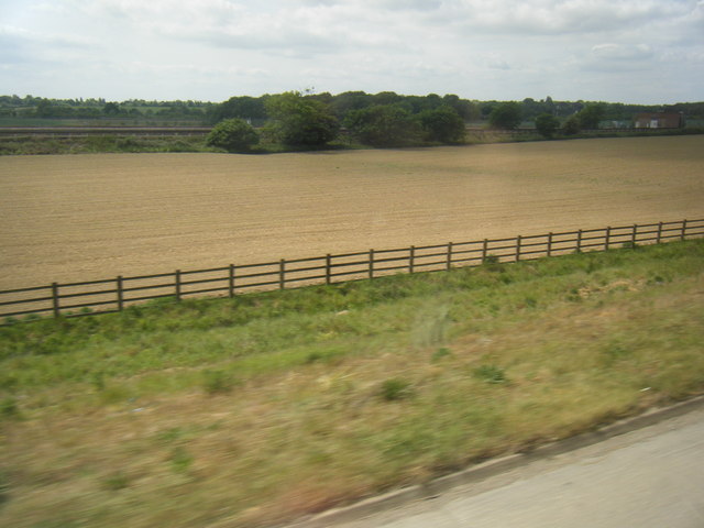
Pigsbrook Wood is a picturesque woodland located in the county of Kent, England. Situated near the village of Pigsbrook, the wood covers an area of approximately 50 acres and is a popular destination for nature lovers and outdoor enthusiasts.

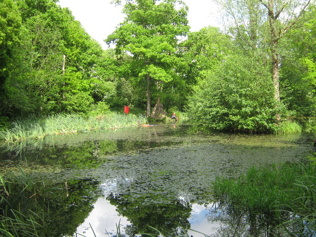
The woodland is characterized by its dense canopy of trees, consisting primarily of oak, beech, and ash trees, which provide ample shade and habitat for a variety of wildlife. The forest floor is covered in a rich carpet of mosses, ferns, and wildflowers, creating a vibrant and colorful landscape throughout the year.

Pigsbrook Wood is intersected by a network of well-maintained footpaths and trails, allowing visitors to explore the area on foot and enjoy its natural beauty. These paths meander through the wood, offering glimpses of tranquil streams and small ponds, which are home to a diverse range of aquatic creatures.

The wood is teeming with wildlife, making it a haven for birdwatchers and nature photographers. It is not uncommon to spot species such as woodpeckers, owls, and various songbirds, as well as small mammals like squirrels and hedgehogs. In the spring and summer months, the wood comes alive with the sounds of chirping birds and buzzing insects.

Pigsbrook Wood also holds historical significance, with remnants of ancient settlements and burial mounds dating back to the Bronze Age. Archaeological excavations have unearthed artifacts and evidence of human activity, offering glimpses into the area's rich past.

Overall, Pigsbrook Wood in Kent is a treasure trove of natural beauty, offering visitors a chance to immerse themselves in a peaceful and enchanting woodland setting.

If you have any feedback on the listing, please let us know in the comments section below.

Pigsbrook Wood Images

Images are sourced within 2km of 51.164986/0.8338045 or Grid Reference TQ9844. Thanks to Geograph Open Source API. All images are credited.

M20 north of Ashford Warren The M20 is a 51 mile motorway running between the M25 motorway near Swanley and Folkestone in Kent. It was constructed from 1960. It is a key route for lorries connecting to mainland Europe via the Channel Tunnel and Ferries.
M20 north of Ashford Warren
The M20 is a 51 mile motorway running between the M25 motorway near Swanley and Folkestone in Kent. It was constructed from 1960. It is a key route for lorries connecting to mainland Europe via the Channel Tunnel and Ferries.
Fields and railway line from M20
Hothfield Heathlands 83 hectares of heathland and lowland valley bogs with river side, meadows and secondary woodland.  
Jointly owned by Ashford Borough Council and Kent Wildlife Trust, Hothfield Heathlands contains Kent’s last four valley bogs and one of its few remaining fragments of open heath with patches of acid grassland.
Hothfield Heathlands
83 hectares of heathland and lowland valley bogs with river side, meadows and secondary woodland. Jointly owned by Ashford Borough Council and Kent Wildlife Trust, Hothfield Heathlands contains Kent’s last four valley bogs and one of its few remaining fragments of open heath with patches of acid grassland.
Hothfield Bog 83 hectares of heathland and lowland valley bogs with river side, meadows and secondary woodland.  
Jointly owned by Ashford Borough Council and Kent Wildlife Trust, Hothfield Heathlands contains Kent’s last four valley bogs and one of its few remaining fragments of open heath with patches of acid grassland.
Hothfield Bog
83 hectares of heathland and lowland valley bogs with river side, meadows and secondary woodland. Jointly owned by Ashford Borough Council and Kent Wildlife Trust, Hothfield Heathlands contains Kent’s last four valley bogs and one of its few remaining fragments of open heath with patches of acid grassland.
Greensand Way, Hothfield Heathlands 83 hectares of heathland and lowland valley bogs with river side, meadows and secondary woodland.  
Jointly owned by Ashford Borough Council and Kent Wildlife Trust, Hothfield Heathlands contains Kent’s last four valley bogs and one of its few remaining fragments of open heath with patches of acid grassland.
Greensand Way, Hothfield Heathlands
83 hectares of heathland and lowland valley bogs with river side, meadows and secondary woodland. Jointly owned by Ashford Borough Council and Kent Wildlife Trust, Hothfield Heathlands contains Kent’s last four valley bogs and one of its few remaining fragments of open heath with patches of acid grassland.
Stile, Greensand Way The Greensand Way is a long distance walk of 108 miles (174 km) in Southeast England, from Haslemere in Surrey to Hamstreet in Kent. It follows the Greensand Ridge along the Surrey Hills and Chart Hills. The route is mostly rural, passing through woods and alongside fruit orchards and hop farms in Kent. and links with the Stour Valley Walk near Pluckley in Kent.

See <span class="nowrap"><a title="http://www.kent.gov.uk/leisure_and_culture/countryside_and_coast/walking/greensand_way.aspx" rel="nofollow ugc noopener" href="http://www.kent.gov.uk/leisure_and_culture/countryside_and_coast/walking/greensand_way.aspx">Link</a><img style="margin-left:2px;" alt="External link" title="External link - shift click to open in new window" src="https://s1.geograph.org.uk/img/external.png" width="10" height="10"/></span> for more details. See also <span class="nowrap"><a title="http://www.walkingpages.co.uk/trails_paths/LDP_greensandway.htm" rel="nofollow ugc noopener" href="http://www.walkingpages.co.uk/trails_paths/LDP_greensandway.htm">Link</a><img style="margin-left:2px;" alt="External link" title="External link - shift click to open in new window" src="https://s1.geograph.org.uk/img/external.png" width="10" height="10"/></span> for more mapping details.
Stile, Greensand Way
The Greensand Way is a long distance walk of 108 miles (174 km) in Southeast England, from Haslemere in Surrey to Hamstreet in Kent. It follows the Greensand Ridge along the Surrey Hills and Chart Hills. The route is mostly rural, passing through woods and alongside fruit orchards and hop farms in Kent. and links with the Stour Valley Walk near Pluckley in Kent. See LinkExternal link for more details. See also LinkExternal link for more mapping details.
Hothfield Common 83 hectares of heathland and lowland valley bogs with river side, meadows and secondary woodland.  
Jointly owned by Ashford Borough Council and Kent Wildlife Trust, Hothfield Heathlands contains Kent’s last four valley bogs and one of its few remaining fragments of open heath with patches of acid grassland.
Hothfield Common
83 hectares of heathland and lowland valley bogs with river side, meadows and secondary woodland. Jointly owned by Ashford Borough Council and Kent Wildlife Trust, Hothfield Heathlands contains Kent’s last four valley bogs and one of its few remaining fragments of open heath with patches of acid grassland.
Hothfield Heathlands 83 hectares of heathland and lowland valley bogs with river side, meadows and secondary woodland.  
Jointly owned by Ashford Borough Council and Kent Wildlife Trust, Hothfield Heathlands contains Kent’s last four valley bogs and one of its few remaining fragments of open heath with patches of acid grassland.
Hothfield Heathlands
83 hectares of heathland and lowland valley bogs with river side, meadows and secondary woodland. Jointly owned by Ashford Borough Council and Kent Wildlife Trust, Hothfield Heathlands contains Kent’s last four valley bogs and one of its few remaining fragments of open heath with patches of acid grassland.
Boardwalk, Hothfield Bog 83 hectares of heathland and lowland valley bogs with river side, meadows and secondary woodland.  
Jointly owned by Ashford Borough Council and Kent Wildlife Trust, Hothfield Heathlands contains Kent’s last four valley bogs and one of its few remaining fragments of open heath with patches of acid grassland.
Boardwalk, Hothfield Bog
83 hectares of heathland and lowland valley bogs with river side, meadows and secondary woodland. Jointly owned by Ashford Borough Council and Kent Wildlife Trust, Hothfield Heathlands contains Kent’s last four valley bogs and one of its few remaining fragments of open heath with patches of acid grassland.
Hothfield Bog 83 hectares of heathland and lowland valley bogs with river side, meadows and secondary woodland.  
Jointly owned by Ashford Borough Council and Kent Wildlife Trust, Hothfield Heathlands contains Kent’s last four valley bogs and one of its few remaining fragments of open heath with patches of acid grassland.
Hothfield Bog
83 hectares of heathland and lowland valley bogs with river side, meadows and secondary woodland. Jointly owned by Ashford Borough Council and Kent Wildlife Trust, Hothfield Heathlands contains Kent’s last four valley bogs and one of its few remaining fragments of open heath with patches of acid grassland.
Kissing gate, Hothfield Common
School Rd, Hothfield
Houses on School Rd, Hothfield Hothfield is a village just off the A20, west of Ashford. On the edge of the village is Hothfield Heathlands and Hothfield Bogs, a SSSI and nature reserve. The village services include a church, village hall, school and Post Office.
Houses on School Rd, Hothfield
Hothfield is a village just off the A20, west of Ashford. On the edge of the village is Hothfield Heathlands and Hothfield Bogs, a SSSI and nature reserve. The village services include a church, village hall, school and Post Office.
Bluebells Children's Centre Hothfield is a village just off the A20, west of Ashford. On the edge of the village is Hothfield Heathlands and Hothfield Bogs, a SSSI and nature reserve. The village services include a church, village hall, school and Post Office.
Bluebells Children's Centre
Hothfield is a village just off the A20, west of Ashford. On the edge of the village is Hothfield Heathlands and Hothfield Bogs, a SSSI and nature reserve. The village services include a church, village hall, school and Post Office.
Hothfield Village Sign King George VI recommended that the old custom of identifying villages with carved or painted name signs could be revived. In 1920, Biddenden had won a Daily Mail competition for a sign featuring the two Biddenden Maids.
More villages followed, especially in 1953, the Coronation of Queen Elizabeth II. More signs have been put up due to the Millennium. This has meant half of the county villages are identified.]
See also <a title="https://www.geograph.org.uk/article/Kent-Village-Signs" href="https://www.geograph.org.uk/article/Kent-Village-Signs">Link</a> , an article on Kent Village Signs
Hothfield Village Sign
King George VI recommended that the old custom of identifying villages with carved or painted name signs could be revived. In 1920, Biddenden had won a Daily Mail competition for a sign featuring the two Biddenden Maids. More villages followed, especially in 1953, the Coronation of Queen Elizabeth II. More signs have been put up due to the Millennium. This has meant half of the county villages are identified.] See also Link , an article on Kent Village Signs
Show me another place!

Pigsbrook Wood is located at Grid Ref: TQ9844 (Lat: 51.164986, Lng: 0.8338045)

Administrative County: Kent

District: Ashford

Police Authority: Kent

What 3 Words

///vital.down.drops. Near Ashford, Kent

Related Wikis

Godinton House

Godinton House (also known as Godinton House and Gardens or Godinton Park) is a stately home in the parish of Great Chart, owned by a non-profit-making...

Hothfield

Hothfield is a village and civil parish in the Ashford Borough of Kent, England and is 3 miles north-west of Ashford on the A20. It is completely split...

Godinton

Godinton (sometimes known as Godinton Park) is a suburb of Ashford, Kent in England, with its stately home Godinton House within its outskirts. Godinton...

Hothfield railway station

Hothfield railway station (later Hothfield Halt) was a railway station on the Maidstone Line at Hothfield, Kent. It was situated between Ashford and Charing...

Hothfield Common

Hothfield Common is a 56.5-hectare (140-acre) biological Site of Special Scientific Interest north-east of Ashford in Kent. It is also a Local Nature...

Ashford Warren and Hoads Wood

Ashford Warren and Hoads Wood is a 34.5-hectare (85-acre) nature reserve north of Ashford in Kent. It is owned by Ashford Borough Council and managed...

Chart Leacon TMD

Chart Leacon Traction and Rolling Stock Maintenance Depot was at one time a railway depot located in Ashford, Kent, England. The depot was situated 1.5...

Highworth Grammar School for Girls

Highworth Grammar School is a selective secondary school (grammar school) in Ashford, Kent. The school also admits boys to the sixth form. At an Ofsted...

Nearby Amenities

Located within 500m of 51.164986,0.8338045
Military: bunker
Lat/Long: 51.1635677/0.8279975
Barrier: cycle_barrier
Lat/Long: 51.1636348/0.8279441
Barrier: stile
Lat/Long: 51.1639397/0.8347083
The data included in this document is from www.openstreetmap.org. The data is made available under ODbL.

Have you been to Pigsbrook Wood?

Leave your review of Pigsbrook Wood below (or comments, questions and feedback).