Luckington Court
Heritage Site in Wiltshire
England
Luckington Court
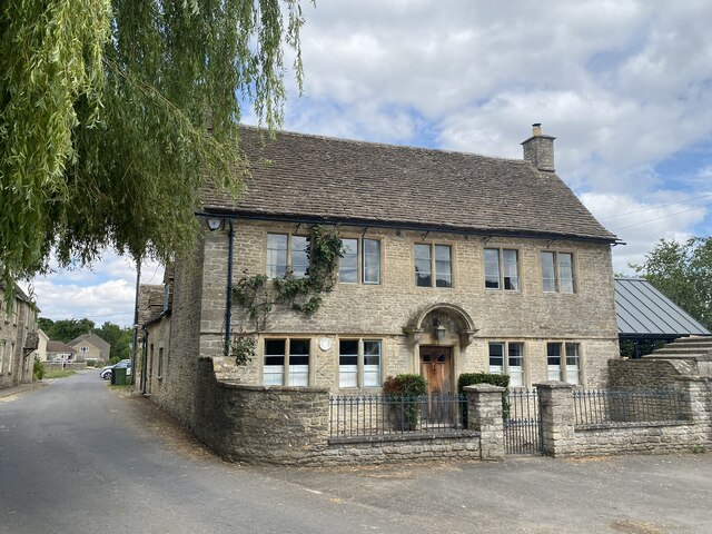
Luckington Court is a historic manor house located in the village of Luckington, Wiltshire, England. This Grade II* listed building dates back to the 16th century, although it has undergone several alterations and additions over the years.
The house is constructed of local stone and features a symmetrical facade with mullioned windows, giving it a distinctive Jacobean style. The interior boasts a wealth of original features, including exposed beams, stone fireplaces, and ornate plasterwork.
One of the notable aspects of Luckington Court is its association with the renowned English author, Jane Austen. It is believed that Austen visited Luckington Court on multiple occasions and used it as inspiration for the fictional Barton Park in her novel "Sense and Sensibility." The house's elegant architecture and picturesque surroundings certainly evoke the charm of Austen's Regency era.
The property also encompasses beautiful gardens and grounds, including a walled garden and a sunken garden. These well-maintained outdoor spaces provide a tranquil setting for visitors to explore and enjoy.
Today, Luckington Court is privately owned and not open to the public. However, the house and its surroundings can be admired from the nearby public footpath, offering glimpses of its historic splendor. Its significance as a heritage site lies in its architectural value, connection to Jane Austen, and contribution to the local history and culture of Wiltshire.
If you have any feedback on the listing, please let us know in the comments section below.
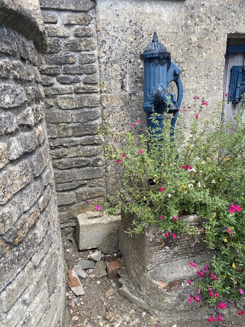
Luckington Court Images
Images are sourced within 2km of 51.558/-2.238 or Grid Reference ST8384. Thanks to Geograph Open Source API. All images are credited.
![Luckington houses [3] Whitehouse, Sherston Road, is a former farmhouse. Built in the 18th century of rendered rubble stone under a stone slate roof. There is a 19th century porch and a later rear wing. Listed, grade II, with details at: <span class="nowrap"><a title="https://historicengland.org.uk/listing/the-list/list-entry/1199810" rel="nofollow ugc noopener" href="https://historicengland.org.uk/listing/the-list/list-entry/1199810">Link</a><img style="margin-left:2px;" alt="External link" title="External link - shift click to open in new window" src="https://s1.geograph.org.uk/img/external.png" width="10" height="10"/></span>
Luckington is a village in northwest Wiltshire, close to the border with Gloucestershire, some 6½ miles southwest of Malmesbury and about 8½ miles northwest of Chippenham. The village is mentioned in the Domesday Book as Lochintone. Five roads meet at Luckington, including the former main Oxford to Bristol road via Malmesbury and Sherston.](https://s1.geograph.org.uk/geophotos/07/54/01/7540121_65938d25.jpg)
![Luckington houses [4] Rose Cottage, Sherston Road, was formerly two cottages, now one. Built circa 1800 and mid 19th century of rubble stone, with roofs partly of stone slate and partly of Bridgwater tiles. Listed, for group value, grade II, with details at: <span class="nowrap"><a title="https://historicengland.org.uk/listing/the-list/list-entry/1022380" rel="nofollow ugc noopener" href="https://historicengland.org.uk/listing/the-list/list-entry/1022380">Link</a><img style="margin-left:2px;" alt="External link" title="External link - shift click to open in new window" src="https://s1.geograph.org.uk/img/external.png" width="10" height="10"/></span>
Luckington is a village in northwest Wiltshire, close to the border with Gloucestershire, some 6½ miles southwest of Malmesbury and about 8½ miles northwest of Chippenham. The village is mentioned in the Domesday Book as Lochintone. Five roads meet at Luckington, including the former main Oxford to Bristol road via Malmesbury and Sherston.](https://s3.geograph.org.uk/geophotos/07/54/01/7540123_f1de2f74.jpg)
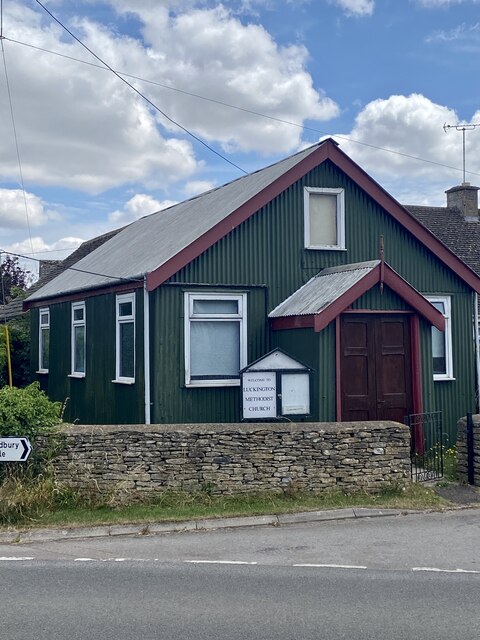
![Luckington buildings [7] This Primitive Methodist chapel was opened in 1903. Built of corrugated iron in tin tabernacle style.
Luckington is a village in northwest Wiltshire, close to the border with Gloucestershire, some 6½ miles southwest of Malmesbury and about 8½ miles northwest of Chippenham. The village is mentioned in the Domesday Book as Lochintone. Five roads meet at Luckington, including the former main Oxford to Bristol road via Malmesbury and Sherston.](https://s2.geograph.org.uk/geophotos/07/54/01/7540126_04f27934.jpg)
![Luckington buildings [8] This school was built as a National School in 1874. It later became Luckington Primary School and was renamed Luckington Community School in 2010. Constructed of rendered brick under a slate roof.
Luckington is a village in northwest Wiltshire, close to the border with Gloucestershire, some 6½ miles southwest of Malmesbury and about 8½ miles northwest of Chippenham. The village is mentioned in the Domesday Book as Lochintone. Five roads meet at Luckington, including the former main Oxford to Bristol road via Malmesbury and Sherston.](https://s2.geograph.org.uk/geophotos/07/54/01/7540130_0fc2d88c.jpg)
Luckington Court is located at Grid Ref: ST8384 (Lat: 51.558, Lng: -2.238)
Unitary Authority: Wiltshire
Police Authority: Wiltshire
What 3 Words
///marathons.funny.formally. Near Luckington, Wiltshire
Nearby Locations
Related Wikis

Luckington
Luckington is a village and civil parish in the southern Cotswolds, in north-west Wiltshire, England, about 6+1⁄2 miles (10 km) west of Malmesbury. The...
Alderton, Wiltshire
Alderton is a village and former civil parish, now in the parish of Luckington, in Wiltshire, England, 6 miles (9.7 km) southwest of Malmesbury. In 1931...

Sopworth
Sopworth is a small village and civil parish in northwest Wiltshire, England, on the county's border with Gloucestershire. The village lies about 1.7 miles...

Alderton Tunnel
The Alderton Tunnel sits on the South Wales Main Line in England, on a stretch of line between Swindon and Bristol Parkway. The tunnel, which is 506 yards...
Nearby Amenities
Located within 500m of 51.558,-2.238Have you been to Luckington Court?
Leave your review of Luckington Court below (or comments, questions and feedback).