Marsh

Settlement in Lancashire Lancaster

England

Marsh

Sunset over waterlogged field Between Aldcliffe and Stodday, SW of Lancaster.
Sunset over waterlogged field Credit: Ian Taylor

Marsh is a small village located in the county of Lancashire, England. Situated in the Wyre borough, it is positioned approximately 4 miles northeast of the town of Thornton-Cleveleys. Marsh falls within the civil parish of Thornton and is part of the North West region of England.

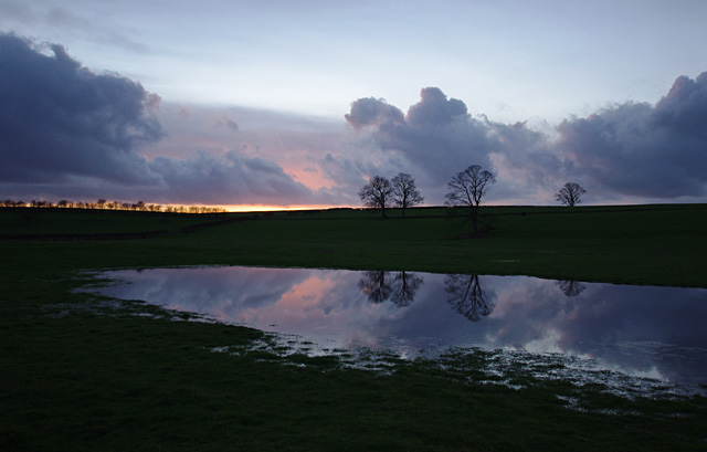
The village of Marsh is characterized by its rural charm and picturesque surroundings. Surrounded by rolling hills and lush green fields, it offers a peaceful and serene environment for its residents. The village is known for its close-knit community, with a population of around 1,500 people.

Marsh is primarily a residential area, with a mix of housing styles ranging from modern developments to traditional cottages. The village benefits from a range of amenities, including a local primary school, a post office, and a handful of shops and pubs. For additional services and facilities, residents can easily access nearby towns and villages.

The village is well-connected in terms of transportation, with good road links to the nearby towns of Cleveleys and Poulton-le-Fylde. The M55 motorway is also within easy reach, providing convenient access to the wider region.

For those seeking outdoor activities, Marsh offers plenty of options. The village is surrounded by beautiful countryside, providing opportunities for hiking, cycling, and exploring the nearby Wyre Forest. Additionally, the picturesque coastline is just a short drive away, offering sandy beaches and seaside attractions.

Overall, Marsh is a charming village in Lancashire that offers a tranquil setting and a strong sense of community for its residents.

If you have any feedback on the listing, please let us know in the comments section below.

Marsh Images

Images are sourced within 2km of 54.049536/-2.8143006 or Grid Reference SD4661. Thanks to Geograph Open Source API. All images are credited.

Sunset over waterlogged field Between Aldcliffe and Stodday, SW of Lancaster.
Sunset over waterlogged field
Between Aldcliffe and Stodday, SW of Lancaster.
OS Bench Mark OS cut bench mark from the 19th century levelling, on a house at the corner of Rydal Road and Ullswater Road.
OS Bench Mark
OS cut bench mark from the 19th century levelling, on a house at the corner of Rydal Road and Ullswater Road.
OS Bench Mark OS cut bench mark from the 19th century levelling, on a building at the corner of Dalton Road and Ullswater Road.
OS Bench Mark
OS cut bench mark from the 19th century levelling, on a building at the corner of Dalton Road and Ullswater Road.
OS Bench Mark OS cut bench mark from the 19th century levelling, on a house at the corner of Borrowdale Road and Ullswater Road.
OS Bench Mark
OS cut bench mark from the 19th century levelling, on a house at the corner of Borrowdale Road and Ullswater Road.
OS Bench Mark OS cut bench mark from the 19th century levelling, on a wall halfway up Borrowdale Road.
OS Bench Mark
OS cut bench mark from the 19th century levelling, on a wall halfway up Borrowdale Road.
OS Bench Mark OS cut bench mark from the 19th century levelling, on a gatepost near the top of Borrowdale Road.
OS Bench Mark
OS cut bench mark from the 19th century levelling, on a gatepost near the top of Borrowdale Road.
OS Bench Mark OS cut bench mark from the 19th century levelling, on a house on Derwent Road.
OS Bench Mark
OS cut bench mark from the 19th century levelling, on a house on Derwent Road.
OS Bench Mark OS cut bench mark from the 19th century levelling, on a door post which used to be part of the Lancaster Union Workhouse, now the Lancaster Royal Grammar School. Severely eroded and hard to see.
OS Bench Mark
OS cut bench mark from the 19th century levelling, on a door post which used to be part of the Lancaster Union Workhouse, now the Lancaster Royal Grammar School. Severely eroded and hard to see.
OS Bench Mark OS cut bench mark from the 19th century levelling, on a gatepost on Quernmore Road. Now rather eroded.
OS Bench Mark
OS cut bench mark from the 19th century levelling, on a gatepost on Quernmore Road. Now rather eroded.
OS Bench Mark OS cut bench mark from the 19th century levelling, on a roadside wall of the Lancaster Royal Grammar School.
OS Bench Mark
OS cut bench mark from the 19th century levelling, on a roadside wall of the Lancaster Royal Grammar School.
OS Bench Mark OS cut bench mark from the 19th century levelling, on a gatepost at the entrance to Cathedral School.
OS Bench Mark
OS cut bench mark from the 19th century levelling, on a gatepost at the entrance to Cathedral School.
OS Bench Mark OS cut bench mark from the 19th century levelling, on a gatepost near the top of Rydal Road. 175.1 feet above old datum. Seems to have been rendered over and now hard to see.
OS Bench Mark
OS cut bench mark from the 19th century levelling, on a gatepost near the top of Rydal Road. 175.1 feet above old datum. Seems to have been rendered over and now hard to see.
OS Bench Mark OS cut bench mark from the 19th century levelling, at the foot of the ginnel connecting Park Road with Derwent Road. 183.2 feet above old datum.
OS Bench Mark
OS cut bench mark from the 19th century levelling, at the foot of the ginnel connecting Park Road with Derwent Road. 183.2 feet above old datum.
OS Bench Mark OS cut bench mark from the 19th century levelling, at the corner of Penny Street and Spring Garden Street. 59.1 feet above old datum.
OS Bench Mark
OS cut bench mark from the 19th century levelling, at the corner of Penny Street and Spring Garden Street. 59.1 feet above old datum.
OS Bench Mark OS cut bench mark from the 19th century levelling, at the corner of Brock Street and Mary Street. 56.2 feet above old datum.
OS Bench Mark
OS cut bench mark from the 19th century levelling, at the corner of Brock Street and Mary Street. 56.2 feet above old datum.
OS Bench Mark OS cut bench mark from the 19th century levelling, on the corner of the Reform Club building. 33.3 feet above old datum.
OS Bench Mark
OS cut bench mark from the 19th century levelling, on the corner of the Reform Club building. 33.3 feet above old datum.
OS Bench Mark OS cut bench mark from the 19th century levelling, on corner of Palatine House, Dalton Square. 53.7 feet above old datum.
OS Bench Mark
OS cut bench mark from the 19th century levelling, on corner of Palatine House, Dalton Square. 53.7 feet above old datum.
OS Bench Mark OS cut bench mark from the 19th century levelling, on Moor Lane below canal bridge. 58.4 feet above old datum.
OS Bench Mark
OS cut bench mark from the 19th century levelling, on Moor Lane below canal bridge. 58.4 feet above old datum.
Show me another place!

Marsh is located at Grid Ref: SD4661 (Lat: 54.049536, Lng: -2.8143006)

Administrative County: Lancashire

District: Lancaster

Police Authority: Lancashire

What 3 Words

///letter.richer.cost. Near Lancaster, Lancashire

Nearby Locations

Marsh Abraham Heights

Related Wikis

Westfield War Memorial Village

Westfield War Memorial Village (established 1924) is a residence in the City of Lancaster, England. Initially created for ex-service men, women and families...

Lancaster Steiner School

Lancaster Steiner School is an independent coeducational school in Lancaster, England, with classes for nursery, kindergarten and grades 1–5. The curriculum...

Lancaster City F.C.

Lancaster City Football Club is an English semi-professional non-League football club based in the northern city of Lancaster, Lancashire. They currently...

Lune Road Ground

Lune Road Ground is a cricket ground in Lancaster, Lancashire. The ground is situated on the bank of the River Lune. The first recorded match on the...

Lancaster railway station

Lancaster railway station (formerly known as Lancaster Castle railway station) is a railway station that serves the city of Lancaster in Lancashire, England...

Friends Meeting House, Lancaster

The Friends Meeting House in Lancaster, Lancashire, England is a Quaker meeting house built in 1708. It is an active Friends meeting house, and a Grade...
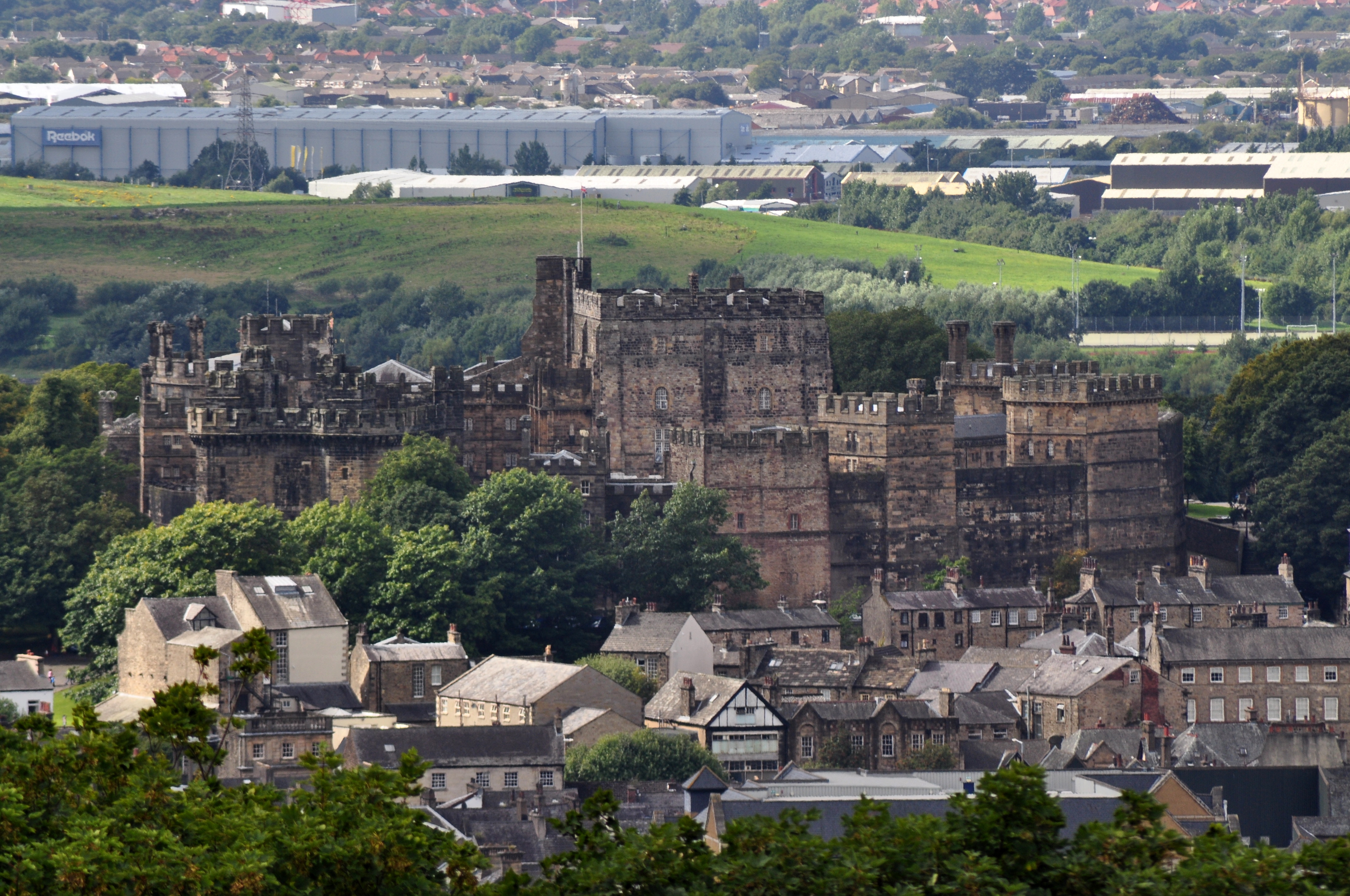
Lancaster Castle

Lancaster Castle is a medieval castle and former prison in Lancaster in the English county of Lancashire. Its early history is unclear, but it may have...

Lancaster Priory

Lancaster Priory, formally the Priory Church of St Mary, is the Church of England parish church of the city of Lancaster, Lancashire, England. It is located...

Nearby Amenities

Located within 500m of 54.049536,-2.8143006
Source: PGS
Lat/Long: 54.0535686/-2.8147817
Source: PGS
Lat/Long: 54.0534268/-2.8153559
Source: PGS
Lat/Long: 54.0533084/-2.8157485
Westfield Village
Bus: yes
Public Transport: stop_position
Lat/Long: 54.0495772/-2.8109436
Give Way
Direction: forward
Lat/Long: 54.0466611/-2.8192931
Turning Circle
Lat/Long: 54.0512245/-2.8091424
Lancaster Castle
Historic Railway: station
Railway: site
Source: OS 1:25k
Lat/Long: 54.0494064/-2.8083673
Barrier: bollard
Bicycle: designated
Bollard: removable
Foot: designated
Motor Vehicle: no
Lat/Long: 54.0508099/-2.8082242
Turning Circle
Lat/Long: 54.0481549/-2.8111604
Turning Circle
Lat/Long: 54.0488433/-2.807004
Turning Circle
Lat/Long: 54.0474823/-2.8126619
Spar
Addr City: Lancaster
Addr Postcode: LA1 5NA
Addr Street: Willow Lane
Brand: Spar
Brand Wikidata: Q610492
Fhrs Id: 112474
Shop: convenience
Source Addr: FHRS Open Data
Wheelchair: yes
Lat/Long: 54.0470717/-2.8195662
Barrier: bollard
Bicycle: yes
Bollard: removable
Foot: yes
Lat/Long: 54.0471297/-2.8138837
Barrier: bollard
Bollard: fixed
Foot: yes
Motor Vehicle: no
Lat/Long: 54.0508261/-2.8147014
Barrier: bollard
Bicycle: yes
Bollard: fixed
Foot: yes
Motor Vehicle: no
Lat/Long: 54.0495653/-2.817638
Barrier: bollard
Bicycle: yes
Bollard: fixed
Foot: yes
Motor Vehicle: no
Lat/Long: 54.0496907/-2.8173045
Barrier: bollard
Foot: yes
Motor Vehicle: no
Lat/Long: 54.0497129/-2.8155661
Railway: switch
Lat/Long: 54.0504542/-2.8083646
Railway: switch
Lat/Long: 54.0511457/-2.8088322
Lancaster
Local Ref: 5
Public Transport: stop_position
Railway: stop
Train: yes
Lat/Long: 54.0481492/-2.8070828
Railway: switch
Lat/Long: 54.0525201/-2.8086281
Lancaster
Local Ref: 3
Public Transport: stop_position
Railway: stop
Train: yes
Lat/Long: 54.0497789/-2.8083168
Railway: signal
Ref: PN238
Lat/Long: 54.0481403/-2.807042
Barrier: bollard
Bollard: fixed
Foot: yes
Motor Vehicle: no
Lat/Long: 54.05103/-2.8129542
Noexit: yes
Lat/Long: 54.0522065/-2.8109719
Distance: 0
Level: 0
Railway: milepost
Lat/Long: 54.0491807/-2.8077913
Entrance: yes
Lat/Long: 54.0488023/-2.8072142
Description: Main entrance to platforms 4 and 5
Entrance: main
Level: 1
Note: This entrance is accessible at ground level, but tagged as level 1 because the station is on a hill. The walkway over the tracks is at the same level as this entrance.
Lat/Long: 54.0488111/-2.8070912
Barrier: bollard
Bicycle: yes
Bollard: removable
Foot: yes
Motor Vehicle: no
Lat/Long: 54.0493091/-2.8085766
Turning Circle
Lat/Long: 54.0499416/-2.8076668
Bus Stop
Sibsey Street
Bench: no
Bin: no
Bus: yes
Lit: yes
Naptan AtcoCode: 2500DCL3070
Naptan Bearing: W
Naptan CommonName: Sibsey Street
Naptan Indicator: by
Naptan Landmark: Sibsey Street
Naptan LocalityCode: N0078718
Naptan NaptanCode: landgmgm
Naptan Street: Westbourne Road
Naptan Verified: yes
Public Transport: platform
Ref: landgmgm
Shelter: no
Tactile Paving: no
Lat/Long: 54.0478932/-2.8089229
Post Box
Collection Times: Mo-Fr 09:00; Sa 07:00
Post Box Type: pillar
Ref: LA1 50
Royal Cypher: VR
Royal Cypher Wikidata: Q33102356
Lat/Long: 54.0478426/-2.8172508
Bus Stop
Coverdale Road
Bench: yes
Bin: no
Check Date Shelter: 2023-06-06
Lit: yes
Naptan AtcoCode: 2500DCL3068
Naptan Bearing: NE
Naptan CommonName: Coverdale Road
Naptan Indicator: opp
Naptan LocalityCode: N0078707
Naptan NaptanCode: landgmga
Naptan Street: Willow Lane
Public Transport: platform
Ref: landgmga
Shelter: yes
Tactile Paving: no
Lat/Long: 54.0477594/-2.8180689
Bus Stop
Willow Lane School
Bench: yes
Bin: no
Check Date Shelter: 2023-06-06
Lit: yes
Naptan AtcoCode: 2500LA00224
Naptan Bearing: NE
Naptan CommonName: Willow Lane School
Naptan Indicator: opp
Naptan LocalityCode: N0078707
Naptan NaptanCode: langpgtw
Naptan Street: Willows Lane
Public Transport: platform
Ref: langpgtw
Shelter: yes
Tactile Paving: no
Lat/Long: 54.0485102/-2.8160523
Bus Stop
Victoria
Bench: yes
Bin: yes
Check Date Shelter: 2023-06-06
Lit: yes
Naptan AtcoCode: 25003066
Naptan Bearing: NE
Naptan CommonName: Victoria
Naptan Indicator: opp
Naptan LocalityCode: N0078707
Naptan NaptanCode: lanawdmg
Naptan Street: Willow Lane
Public Transport: platform
Ref: lanawdmg
Shelter: yes
Tactile Paving: no
Lat/Long: 54.0504605/-2.8134023
Library
Marsh Community Centre
Lat/Long: 54.0500339/-2.8143001
Bus Stop
Fairfield Road
Bus: yes
Naptan AtcoCode: 2500DCL3071
Naptan Bearing: N
Naptan BusStopType: MKD
Naptan CommonName: Fairfield Road
Naptan Indicator: by
Naptan Landmark: Fairfield Road
Naptan LocalityCode: N0078718
Naptan NaptanCode: landgmgp
Naptan Street: Fairfield Road
Naptan Verified: no
Public Transport: platform
Ref: landgmgp
Lat/Long: 54.0490005/-2.8095549
Bus Stop
Westfield Village
Bench: no
Bin: yes
Bus: yes
Lit: yes
Naptan AtcoCode: 2500DCL3064
Naptan Bearing: SE
Naptan CommonName: Westfield Village
Naptan Indicator: by
Naptan LocalityCode: N0078707
Naptan NaptanCode: landgmdp
Naptan Street: West Road
Public Transport: platform
Ref: landgmdp
Shelter: yes
Tactile Paving: no
Lat/Long: 54.0495967/-2.8108805
Bus Stop
Meeting House Lane
Bench: no
Bin: no
Bus: yes
Lit: yes
Naptan AtcoCode: 2500LA00223
Naptan Bearing: E
Naptan CommonName: Meeting House Lane
Naptan Indicator: by
Naptan Landmark: Meeting House Lane
Naptan LocalityCode: N0078718
Naptan NaptanCode: langpgtp
Naptan Street: Meeting House Lane
Naptan Verified: yes
Public Transport: platform
Ref: langpgtp
Shelter: no
Tactile Paving: no
Wheelchair: yes
Lat/Long: 54.0480831/-2.8074145
Bus Stop
Westfield Village
Bench: no
Bin: no
Bus: yes
Lit: yes
Naptan AtcoCode: 2500LAA07486
Naptan Bearing: NW
Naptan BusStopType: MKD
Naptan CommonName: Westfield Village
Naptan Indicator: adj
Naptan Landmark: Storey Ave
Naptan LocalityCode: N0078707
Naptan NaptanCode: lanjpgpa
Naptan Street: West Road
Naptan Verified: yes
Public Transport: platform
Ref: lanjpgpa
Shelter: no
Tactile Paving: no
Lat/Long: 54.0497445/-2.8113873
Lancaster
Local Ref: 1
Public Transport: stop_position
Railway: stop
Train: yes
Lat/Long: 54.049755/-2.8085731
Lancaster
Local Ref: 2
Public Transport: stop_position
Railway: stop
Train: yes
Lat/Long: 54.0497632/-2.808515
Cafe
Costa
Addr City: Lancaster
Addr Housename: Lancaster Railway Station
Addr Postcode: LA1 5NW
Addr Street: Westbourne Road
Brand: Costa
Brand Wikidata: Q608845
Brand Wikipedia: en:Costa Coffee
Cuisine: coffee_shop
Diet Vegan: limited
Diet Vegetarian: yes
Fhrs Id: 81714
Level: 0
Opening Hours: Mo-Fr 06:00-19:30; Sa 06:30-19:00; Su 09:00-17:00
Operator: Caterleisure Services Ltd
Outdoor Seating: yes
Phone: +44 1524 844653
Smoking: no
Takeaway: yes
Wheelchair: limited
Lat/Long: 54.0486025/-2.8074586
Turning Circle
Lat/Long: 54.0480585/-2.8120243
Fast Food
Boon
Addr City: Lancaster
Addr Postcode: LA1 5NA
Addr Street: Willow Lane
Cuisine: chinese
Drive Through: no
Fhrs Id: 103585
Takeaway: only
Lat/Long: 54.0471993/-2.8194643
Fast Food
Windmill Takeaway
Addr City: Lancaster
Addr Housenumber: 1
Addr Postcode: LA1 5PG
Addr Street: West Road
Cuisine: fish_and_chips;chinese
Delivery: yes
Drive Through: no
Fhrs Id: 120046
Opening Hours: Tu-Sa 11:30-14:00,16:30-22:30; Su 16:30-22:30
Payment Cash: only
Phone: +44 1524 942925
Source Addr: FHRS Open Data
Lat/Long: 54.0509476/-2.8128805
Waste Basket
Check Date: 2023-06-06
Lat/Long: 54.050787/-2.8127973
Fast Food
Pepe's Plaice
Addr City: Lancaster
Addr Housenumber: 9
Addr Postcode: LA1 5PG
Addr Street: West Road
Contact Facebook: https://www.facebook.com/Me-Dads-Chippy-103933941840651
Cuisine: fish_and_chips
Drive Through: no
Fhrs Id: 89737
Level: 0
Old Name: Me Dad's Chippy
Source Addr: FHRS Open Data
Website: https://medadchippy.uk/
Lat/Long: 54.0506724/-2.8125095
Post Box
Collection Times: Mo-Fr 09:00; Sa 07:00
Post Box Type: wall
Ref: LA1 22D
Royal Cypher: EVIIR
Royal Cypher Wikidata: Q33102324
Lat/Long: 54.0476961/-2.8104354
Post Box
Collection Times: Mo-Fr 09:00; Sa 07:00
Post Box Type: pillar
Ref: LA1 17
Royal Cypher: GR
Royal Cypher Wikidata: Q33102273
Lat/Long: 54.0503759/-2.8124861
Barrier: block
Lat/Long: 54.0485867/-2.8206929
Taxi
Rail Station Taxi Rank
Capacity: 10
Naptan AtcoCode: 2500X00025
Naptan CommonName: Rail Station Taxi Rank
Naptan Indicator: by
Naptan Landmark: Rail Station Taxi Rank
Naptan LocalityCode: N0078718
Naptan NaptanCode: lanjmtpw
Naptan Street: Station Road
Naptan Verified: yes
Ref: lanjmtpw
Lat/Long: 54.0487919/-2.8083452
Lancaster
Local Ref: 4
Public Transport: stop_position
Railway: stop
Train: yes
Lat/Long: 54.0481543/-2.8073715
Description: Main entrance to platforms 1 - 3
Entrance: main
Level: 0
Wheelchair: designated
Lat/Long: 54.0488396/-2.8081796
Noexit: yes
Lat/Long: 54.0490732/-2.808382
Bus Stop
Railway Station
Bench: no
Bin: no
Bus: yes
Lit: yes
Naptan AtcoCode: 2500IMG1260
Naptan Bearing: S
Naptan CommonName: Railway Station
Naptan Indicator: o/s
Naptan Landmark: Railway Station
Naptan LocalityCode: N0078718
Naptan NaptanCode: landptad
Naptan Street: Station Road
Naptan Verified: yes
Public Transport: platform
Ref: landptad
Shelter: yes
Tactile Paving: no
Wheelchair: yes
Lat/Long: 54.0487252/-2.8081601
Premier - Fairfield Stores
Addr City: Lancaster
Addr Housenumber: 6
Addr Postcode: LA1 5DF
Addr Street: Sibsey Street
Brand: Premier
Brand Wikidata: Q7240340
Fhrs Id: 142804
Operator: Fairfield Stores Ltd
Payment Cash: yes
Payment Debit Cards: yes
Shop: convenience
Website: https://www.premier-stores.co.uk/our-stores/fairfield-convenience-store-1
Lat/Long: 54.0474199/-2.8083771
Turning Circle
Lat/Long: 54.0518624/-2.8172807
Turning Circle
Lat/Long: 54.0511315/-2.8181235
Turning Circle
Lat/Long: 54.050603/-2.8187359
Noexit: yes
Lat/Long: 54.0502169/-2.8191361
Turning Circle
Lat/Long: 54.0503655/-2.8200761
Noexit: yes
Lat/Long: 54.0522737/-2.8167788
Noexit: yes
Lat/Long: 54.0507779/-2.8185732
Noexit: yes
Lat/Long: 54.0508396/-2.8184607
Noexit: yes
Lat/Long: 54.0503384/-2.8191157
Turning Circle
Lat/Long: 54.0498753/-2.8196775
Bicycle Parking
Access: customers
Bicycle Parking: semi_upright
Capacity: 100
Covered: yes
Fee: no
Operator: Lancaster Train Station
Lat/Long: 54.0493146/-2.8083631
Bicycle Parking
Access: customers
Bicycle Parking: stands
Capacity: 12
Covered: yes
Fee: no
Level: 0
Operator: Lancaster Train Station
Lat/Long: 54.0491152/-2.8077249
Direction: forward
Surface: asphalt
Traffic Calming: table
Lat/Long: 54.0492185/-2.8217953
Bicycle Parking
Access: customers
Bicycle Parking: stands
Capacity: 12
Covered: yes
Fee: no
Level: 0
Operator: Lancaster Train Station
Lat/Long: 54.0491929/-2.8077666
Bicycle Parking
Bicycle Parking: stands
Capacity: 40
Covered: yes
Level: 0
Lat/Long: 54.0489789/-2.8075516
Waste Basket
Lat/Long: 54.048308/-2.8095402
Bus Stop
Railway Station
Bench: yes
Bin: no
Bus: yes
Departures Board: timetable
Lit: yes
Naptan AtcoCode: 2500894
Naptan Bearing: S
Naptan BusStopType: MKD
Naptan CommonName: Railway Station
Naptan Indicator: opp
Naptan Landmark: Railway Station
Naptan LocalityCode: N0078718
Naptan NaptanCode: landagmt
Naptan Street: Station Road
Naptan Verified: yes
Public Transport: platform
Ref: landagmt
Shelter: yes
Tactile Paving: yes
Lat/Long: 54.048714/-2.8084959
Barrier: bollard
Bicycle: yes
Bollard: fixed
Foot: yes
Motor Vehicle: no
Lat/Long: 54.049323/-2.8073234
Railway Station
Bus: yes
Public Transport: stop_position
Lat/Long: 54.0487351/-2.8082641
Victoria
Bus: yes
Public Transport: stop_position
Lat/Long: 54.0504453/-2.8133375
Willow Lane School
Bus: yes
Public Transport: stop_position
Lat/Long: 54.0484783/-2.8160161
Coverdale Road
Bus: yes
Public Transport: stop_position
Lat/Long: 54.0476838/-2.8180071
Sibsey Street
Bus: yes
Public Transport: stop_position
Lat/Long: 54.0479527/-2.8089506
Meeting House Lane
Bus: yes
Public Transport: stop_position
Lat/Long: 54.0480471/-2.8074088
Bus Stop
Cricket Club
Bench: no
Bus: yes
Naptan AtcoCode: 2500LAA07487
Naptan Bearing: N
Naptan BusStopType: MKD
Naptan CommonName: Cricket Club
Naptan Indicator: by
Naptan Landmark: Cricket Club
Naptan LocalityCode: N0078707
Naptan NaptanCode: lanjpgpd
Naptan Street: Lune Road
Naptan Verified: yes
Public Transport: platform
Ref: lanjpgpd
Shelter: no
Lat/Long: 54.052365/-2.8134161
Cricket Club
Bus: yes
Public Transport: stop_position
Lat/Long: 54.0523702/-2.8133253
Westfield Village
Bus: yes
Public Transport: stop_position
Lat/Long: 54.0497688/-2.8113244
Railway Station
Bus: yes
Public Transport: stop_position
Lat/Long: 54.0487216/-2.8084269
Noexit: yes
Lat/Long: 54.0514746/-2.8177376
Noexit: yes
Lat/Long: 54.0520288/-2.8099499
Barrier: bollard
Bollard: fixed
Foot: yes
Motor Vehicle: no
Lat/Long: 54.0507419/-2.816356
Barrier: bollard
Bollard: fixed
Foot: yes
Motor Vehicle: no
Lat/Long: 54.0507857/-2.8155397
Barrier: bollard
Bollard: fixed
Foot: yes
Motor Vehicle: no
Lat/Long: 54.0506144/-2.8172035
Noexit: yes
Lat/Long: 54.0472692/-2.8201684
Direction: forward
Priority: forward
Traffic Calming: choker
Lat/Long: 54.0477459/-2.8178089
Direction: backward
Priority: forward
Traffic Calming: choker
Lat/Long: 54.0478639/-2.8174325
Direction: forward
Priority: backward
Traffic Calming: choker
Lat/Long: 54.0480718/-2.8168485
Direction: forward
Priority: backward
Traffic Calming: choker
Lat/Long: 54.048733/-2.815503
Marsh
Place: suburb
Lat/Long: 54.0504659/-2.8149575
Covered: no
Leisure: picnic_table
Lat/Long: 54.0494729/-2.8179289
Covered: no
Leisure: picnic_table
Lat/Long: 54.049454/-2.818004
Access: yes
Entrance: gate
Lat/Long: 54.0494202/-2.8177729
Coverdale Road
Bench: no
Bin: no
Lit: yes
Naptan AtcoCode: 2500IMG1258
Naptan Bearing: SW
Naptan BusStopType: MKD
Naptan CommonName: Coverdale Road
Naptan Indicator: by
Naptan Landmark: Coverdale Road
Naptan LocalityCode: N0078707
Naptan NaptanCode: landpmwp
Naptan Street: Willow Lane
Naptan Verified: no
Public Transport: platform
Ref: landpmwp
Shelter: no
Tactile Paving: no
Lat/Long: 54.0474649/-2.8184123
Coverdale Road
Bus: yes
Public Transport: stop_position
Lat/Long: 54.0474901/-2.8184576
Willow Lane Infant School
Bench: no
Bin: no
Lit: yes
Naptan AtcoCode: 2500IMG1256
Naptan Bearing: SW
Naptan BusStopType: MKD
Naptan CommonName: Willow Lane Infant School
Naptan Indicator: o/s
Naptan Landmark: MARSH Willow Lane Infant School
Naptan LocalityCode: N0078707
Naptan NaptanCode: landpmwj
Naptan Street: Willow Lane
Naptan Verified: no
Public Transport: platform
Ref: landpmwj
Shelter: no
Tactile Paving: no
Lat/Long: 54.0487978/-2.8152897
Willow Lane Infant School
Bus: yes
Public Transport: stop_position
Lat/Long: 54.0488227/-2.8153262
Victoria
Bench: no
Bin: no
Lit: yes
Naptan AtcoCode: 2500IMG1254
Naptan Bearing: SW
Naptan BusStopType: MKD
Naptan CommonName: Victoria
Naptan Indicator: by
Naptan Landmark: Victoria
Naptan LocalityCode: N0078707
Naptan NaptanCode: landpmwd
Naptan Street: Willow Lane
Naptan Verified: no
Public Transport: platform
Ref: landpmwd
Shelter: no
Tactile Paving: no
Lat/Long: 54.0506329/-2.8130825
Victoria
Bus: yes
Public Transport: stop_position
Lat/Long: 54.0506491/-2.8131357
Fairfield Road
Bus: yes
Public Transport: stop_position
Lat/Long: 54.0489984/-2.8094818
Noexit: yes
Lat/Long: 54.0515966/-2.8122993
Crossing
Crossing: marked
Crossing Island: no
Tactile Paving: yes
Lat/Long: 54.0529189/-2.816199
The War Memorial
HE Ref: 1195055
Artist Name: Jennie Delahunt
Historic: memorial
Inscription: THE WESTFIELD WAR / MEMORIAL VILLAGE / FOUNDED IN GRATEFUL / REMEMBRANCE OF THE / SACRIFICE MADE BY THE / KING'S OWN ROYAL / LANCASTER REGIMENT / THE LANCASTER BATTERIES / OF ARTILLERY AND OTHER / LANCASTRIANS IN / THE GREAT WAR / 1914 – 1918 / THE CHILDR
Listed Status: Grade II*
Memorial: war_memorial
Start Date: 1926
Lat/Long: 54.0484402/-2.8124088
Entrance: yes
Level: 0
Lat/Long: 54.0487676/-2.8079531
Entrance: yes
Lat/Long: 54.0486279/-2.8075285
Entrance: yes
Lat/Long: 54.0486586/-2.8073338
Toilets
Access: yes
Changing Table: no
Fee: no
Level: 0
Male: yes
Operator: Avanti West Coast
Toilets Disposal: flush
Toilets Position: seated;urinal
Wheelchair: yes
Lat/Long: 54.0482799/-2.8073335
Toilets
Access: yes
Changing Table: no
Fee: no
Female: yes
Level: 0
Male: yes
Operator: Avanti West Coast
Toilets Disposal: flush
Toilets Position: seated;urinal
Wheelchair: no
Lat/Long: 54.0490837/-2.8081307
Bicycle Parking
Access: yes
Bicycle Parking: stands
Capacity: 8
Covered: no
Fee: no
Lat/Long: 54.0485287/-2.8080785
Barrier: bollard
Bicycle: designated
Bollard: removable
Foot: designated
Motor Vehicle: no
Lat/Long: 54.0510828/-2.8091379
Telephone
Check Date: 2023-06-21
Level: 1
Lat/Long: 54.0488779/-2.8071402
Telephone
Check Date: 2023-06-21
Level: 1
Lat/Long: 54.0488951/-2.8071492
Vending Machine
Level: 1
Vending: public_transport_tickets
Lat/Long: 54.0487981/-2.8071941
Vending Machine
Level: 1
Vending: public_transport_tickets
Lat/Long: 54.048806/-2.8071986
Elevator
Level: 0;1
Wheelchair: yes
Lat/Long: 54.0487281/-2.8079516
Vending Machine
Currency GBP: yes
Level: 0
Payment Credit Cards: yes
Payment Debit Cards: yes
Vending: public_transport_tickets
Lat/Long: 54.0487353/-2.8080618
Bicycle Repair Station
Fee: no
Service Bicycle Diy: yes
Service Bicycle Pump: yes
Lat/Long: 54.0493447/-2.8083568
Bicycle Parking
Access: customers
Bicycle Parking: stands
Capacity: 16
Covered: yes
Fee: no
Level: 0
Operator: Lancaster Train Station
Lat/Long: 54.0497291/-2.8083926
Pub
Hornet's Bar
Addr City: Lancaster
Addr Postcode: LA1 5TQ
Addr Street: Hornbeam Road
Lat/Long: 54.0475132/-2.8200864
Ajax MOT Center
Shop: car_repair
Lat/Long: 54.047613/-2.820016
Entrance: yes
Lat/Long: 54.0491873/-2.8069143
Entrance: yes
Lat/Long: 54.0491524/-2.8069113
Barrier: entrance
Lat/Long: 54.0492729/-2.8071542
Barrier: bollard
Bicycle: designated
Bollard: fixed
Foot: designated
Lat/Long: 54.0493534/-2.8086397
Give Way
Direction: forward
Lat/Long: 54.0485478/-2.808291
Give Way
Direction: backward
Lat/Long: 54.0488582/-2.8084184
Waste Basket
Lat/Long: 54.0484582/-2.8082282
Give Way
Direction: backward
Lat/Long: 54.048449/-2.8083518
Give Way
Direction: forward
Lat/Long: 54.0480451/-2.8081177
Entrance: main
Wheelchair: no
Lat/Long: 54.0482648/-2.8083284
Entrance: main
Wheelchair: no
Lat/Long: 54.048583/-2.8084587
Give Way
Direction: forward
Lat/Long: 54.0500448/-2.807537
Cannon Hill
Bus: yes
Departures Board: no
Operator: Stagecoach
Public Transport: stop_position
Lat/Long: 54.0451116/-2.8154782
Railway: switch
Lat/Long: 54.05238/-2.8087583
Generator Method: photovoltaic
Generator Orientation: south_west
Generator Output Electricity: yes
Generator Solar Modules: 8
Generator Source: solar
Generator Type: solar_photovoltaic_panel
Location: roof
Power: generator
Lat/Long: 54.0525853/-2.8120779
Generator Method: photovoltaic
Generator Orientation: south
Generator Output Electricity: yes
Generator Solar Modules: 15
Generator Source: solar
Generator Type: solar_photovoltaic_panel
Location: roof
Power: generator
Lat/Long: 54.0524094/-2.8156188
Generator Method: photovoltaic
Generator Orientation: south
Generator Output Electricity: yes
Generator Solar Modules: 8
Generator Source: solar
Generator Type: solar_photovoltaic_panel
Location: roof
Power: generator
Lat/Long: 54.0517317/-2.8147309
Generator Method: photovoltaic
Generator Orientation: south_west
Generator Output Electricity: yes
Generator Solar Modules: 11
Generator Source: solar
Generator Type: solar_photovoltaic_panel
Location: roof
Power: generator
Lat/Long: 54.0506189/-2.8129111
Generator Method: photovoltaic
Generator Orientation: north_west
Generator Output Electricity: yes
Generator Solar Modules: 12
Generator Source: solar
Generator Type: solar_photovoltaic_panel
Location: roof
Power: generator
Lat/Long: 54.0505777/-2.8130367
Generator Method: photovoltaic
Generator Orientation: south_east
Generator Output Electricity: yes
Generator Solar Modules: 12
Generator Source: solar
Generator Type: solar_photovoltaic_panel
Location: roof
Power: generator
Lat/Long: 54.0505571/-2.8129739
Generator Method: photovoltaic
Generator Orientation: south_west
Generator Output Electricity: yes
Generator Solar Modules: 8
Generator Source: solar
Generator Type: solar_photovoltaic_panel
Location: roof
Power: generator
Lat/Long: 54.0480656/-2.8160316
Generator Method: photovoltaic
Generator Orientation: west
Generator Output Electricity: yes
Generator Solar Modules: 10
Generator Source: solar
Generator Type: solar_photovoltaic_panel
Location: roof
Power: generator
Lat/Long: 54.0467043/-2.8085528
Generator Method: photovoltaic
Generator Orientation: west
Generator Output Electricity: yes
Generator Solar Modules: 6
Generator Source: solar
Generator Type: solar_photovoltaic_panel
Location: roof
Power: generator
Lat/Long: 54.0472238/-2.8083612
Generator Method: photovoltaic
Generator Orientation: east
Generator Output Electricity: yes
Generator Solar Modules: 6
Generator Source: solar
Generator Type: solar_photovoltaic_panel
Location: roof
Power: generator
Lat/Long: 54.0472398/-2.8082938
Generator Method: photovoltaic
Generator Orientation: south
Generator Output Electricity: yes
Generator Solar Modules: 10
Generator Source: solar
Generator Type: solar_photovoltaic_panel
Location: roof
Power: generator
Lat/Long: 54.0460325/-2.8113214
Generator Method: photovoltaic
Generator Orientation: west
Generator Output Electricity: yes
Generator Solar Modules: 7
Generator Source: solar
Generator Type: solar_photovoltaic_panel
Location: roof
Power: generator
Lat/Long: 54.0460411/-2.8113905
Generator Method: photovoltaic
Generator Orientation: south_west
Generator Output Electricity: yes
Generator Solar Modules: 16
Generator Source: solar
Generator Type: solar_photovoltaic_panel
Location: roof
Power: generator
Lat/Long: 54.0460509/-2.8129239
Generator Method: photovoltaic
Generator Orientation: south
Generator Output Electricity: yes
Generator Solar Modules: 6
Generator Source: solar
Generator Type: solar_photovoltaic_panel
Location: roof
Power: generator
Lat/Long: 54.0460927/-2.8165555
Generator Method: photovoltaic
Generator Orientation: west
Generator Output Electricity: yes
Generator Solar Modules: 5
Generator Source: solar
Generator Type: solar_photovoltaic_panel
Location: roof
Power: generator
Lat/Long: 54.0461271/-2.8165806
Generator Method: photovoltaic
Generator Orientation: east
Generator Output Electricity: yes
Generator Solar Modules: 5
Generator Source: solar
Generator Type: solar_photovoltaic_panel
Location: roof
Power: generator
Lat/Long: 54.0461099/-2.816497
Generator Method: photovoltaic
Generator Orientation: south
Generator Output Electricity: yes
Generator Solar Modules: 8
Generator Source: solar
Generator Type: solar_photovoltaic_panel
Location: roof
Power: generator
Lat/Long: 54.0468748/-2.8177893
Generator Method: photovoltaic
Generator Orientation: west
Generator Output Electricity: yes
Generator Solar Modules: 8
Generator Source: solar
Generator Type: solar_photovoltaic_panel
Location: roof
Power: generator
Lat/Long: 54.0520222/-2.8185186
Generator Method: photovoltaic
Generator Orientation: north_west
Generator Output Electricity: yes
Generator Solar Modules: 16
Generator Source: solar
Generator Type: solar_photovoltaic_panel
Location: roof
Power: generator
Lat/Long: 54.0510669/-2.8207215
Lancaster
Naptan AtcoCode: 9100LANCSTR
Network: National Rail
Network Website: https://www.nationalrail.co.uk/stations/lan/
Network Wikidata: Q26334
Public Transport: station
Railway: station
Ref Crs: LAN
Train: yes
Wheelchair: yes
Wikidata: Q763073
Wikipedia: en:Lancaster railway station
Lat/Long: 54.0488361/-2.807799
Elevator
Access: yes
Level: 0;1
Wheelchair: yes
Lat/Long: 54.0487915/-2.8075188
Post Office
Willow Lane Post Office
Addr City: Lancaster
Addr Housenumber: 18
Addr Postcode: LA1 5PP
Addr Street: Willow Lane
Brand: Post Office
Brand Wikidata: Q1783168
Brand Wikipedia: en:Post Office Ltd
Contact Website: https://www.postoffice.co.uk/branch-finder/3574180/willow-lane
Opening Hours: Mo-Sa 06:00-23:00; Su 07:00-23:00
Ref Pol Id: 151447
Lat/Long: 54.0504134/-2.8135903
Give Way
Direction: forward
Lat/Long: 54.0483591/-2.8095421
Give Way
Direction: forward
Lat/Long: 54.0483238/-2.8096039
Give Way
Direction: forward
Lat/Long: 54.049268/-2.8094361
Give Way
Direction: backward
Lat/Long: 54.0479369/-2.8086193
Man Made: street_cabinet
Lat/Long: 54.0478054/-2.8086562
Man Made: street_cabinet
Lat/Long: 54.0478161/-2.8086562
Man Made: street_cabinet
Lat/Long: 54.047871/-2.8084807
Waste Basket
Lat/Long: 54.0478901/-2.8084897
Bench
Backrest: yes
Material: metal
Seats: 2
Lat/Long: 54.0479152/-2.8084953
Generator Method: photovoltaic
Generator Output Electricity: yes
Generator Source: solar
Generator Type: solar_photovoltaic_panel
Power: generator
Lat/Long: 54.0451908/-2.8152697
Barrier: bollard
Bicycle: yes
Bollard: removable
Foot: designated
Motor Vehicle: no
Lat/Long: 54.0491303/-2.8207179
Barrier: lift_gate
Lat/Long: 54.0475864/-2.8081296
Stop
Direction: backward
Stop: minor
Lat/Long: 54.0535826/-2.8137812
Man Made: street_cabinet
Lat/Long: 54.0511141/-2.8090848
Entrance: yes
Lat/Long: 54.048684/-2.807912
Addr Housenumber: 1A
Addr Street: Kelsey Street
Lat/Long: 54.0474161/-2.8084425
Crossing
Crossing: marked
Crossing Island: no
Tactile Paving: yes
Lat/Long: 54.0524897/-2.8183372
Crossing
Crossing: marked
Crossing Island: no
Tactile Paving: yes
Lat/Long: 54.0520012/-2.8205933
Charging Station
Authentication App: yes
Capacity: 1
Fee: yes
Motorcar: yes
Network: Charge My Street
Operator: Charge My Street
Payment App: yes
Ref: EG-04806
Socket Type2: 1
Socket Type2 Current: 32
Socket Type2 Output: 22kW
Socket Type2 Voltage: 415
Lat/Long: 54.0504993/-2.8140194
Charging Station
Authentication App: yes
Capacity: 1
Fee: yes
Motorcar: yes
Network: Charge My Street
Operator: Charge My Street
Payment App: yes
Ref: EG-04807
Socket Type2: 1
Socket Type2 Current: 32
Socket Type2 Output: 22kW
Socket Type2 Voltage: 415
Lat/Long: 54.050498/-2.8140082
Packforce
Addr City: Lancaster
Addr Postcode: LA1 5NA
Addr Street: Hornbeam Road
Man Made: works
Works: meat_processing
Lat/Long: 54.0471319/-2.820531
Toilets
Access: yes
Fee: no
Female: yes
Level: 0
Operator: Avanti West Coast
Toilets Disposal: flush
Wheelchair: yes
Lat/Long: 54.0489522/-2.8076459
Defibrillator
Defibrillator Location: On pillar by entrance to toilets
Emergency: defibrillator
Indoor: no
Lat/Long: 54.0489719/-2.8077254
Addr City: Lancaster
Addr Housenumber: 1
Addr Postcode: LA1 5DB
Addr Street: Westbourne Road
Disused Amenity: social_facility
Level: 0
Old Name: The Olive Branch
Social Facility: food_bank
Lat/Long: 54.0478702/-2.8087282
Entrance: main
Level: 0
Lat/Long: 54.0478837/-2.8086907
Lancaster Junction
Railway: junction
Lat/Long: 54.0514494/-2.8088243
Bench
Lat/Long: 54.0494481/-2.8110355
Bench
Lat/Long: 54.0492563/-2.8112763
Board Type: notice
Information: board
Tourism: information
Lat/Long: 54.0483292/-2.8125476
Grit Bin
Lat/Long: 54.048306/-2.8125577
Bench
Lat/Long: 54.0490286/-2.8111492
Entrance: main
Level: 0
Lat/Long: 54.0538528/-2.8124749
Barrier: bollard
Bollard: fixed
Lat/Long: 54.0527/-2.8116632
Addr Housenumber: 2
Addr Street: West Road
Survey Date: 2022-03-06
Lat/Long: 54.0506571/-2.8128652
Access: private
Entrance: home
Level: 0
Lat/Long: 54.0534216/-2.8112043
Access: private
Entrance: home
Level: 0
Lat/Long: 54.0532958/-2.8112171
Access: private
Entrance: home
Level: 0
Lat/Long: 54.0533112/-2.8112045
Access: private
Entrance: home
Level: 0
Lat/Long: 54.0532616/-2.8112451
Access: private
Entrance: home
Level: 0
Lat/Long: 54.0531874/-2.811393
Entrance: main
Level: 0
Lat/Long: 54.0535078/-2.8133425
Give Way
Direction: backward
Lat/Long: 54.0530433/-2.8133998
What to look out for
Board Type: nature
Information: board
Ref: 5
Tourism: information
Lat/Long: 54.0534407/-2.8145418
Waste Basket
Lat/Long: 54.0538297/-2.813333
Man Made: street_cabinet
Lat/Long: 54.0529473/-2.8158319
Seamark Beacon Special Purpose Colour: yellow
Seamark Beacon Special Purpose Shape: pole
Seamark Type: beacon_special_purpose
Lat/Long: 54.0532828/-2.8163595
Waste Basket
Lat/Long: 54.052959/-2.8163351
Generator Method: photovoltaic
Generator Orientation: south_west
Generator Output Electricity: yes
Generator Solar Modules: 12
Generator Source: solar
Generator Type: solar_photovoltaic_panel
Location: roof
Power: generator
Lat/Long: 54.0532641/-2.8124462
Generator Method: photovoltaic
Generator Orientation: south_west
Generator Output Electricity: yes
Generator Solar Modules: 6
Generator Source: solar
Generator Type: solar_photovoltaic_panel
Location: roof
Power: generator
Lat/Long: 54.0532352/-2.8123296
Generator Method: photovoltaic
Generator Orientation: south_west
Generator Output Electricity: yes
Generator Solar Modules: 6
Generator Source: solar
Generator Type: solar_photovoltaic_panel
Location: roof
Power: generator
Lat/Long: 54.053221/-2.8122705
Generator Method: photovoltaic
Generator Orientation: south_west
Generator Output Electricity: yes
Generator Solar Modules: 6
Generator Source: solar
Generator Type: solar_photovoltaic_panel
Location: roof
Power: generator
Lat/Long: 54.0531449/-2.8120084
Generator Method: photovoltaic
Generator Orientation: south_west
Generator Output Electricity: yes
Generator Solar Modules: 6
Generator Source: solar
Generator Type: solar_photovoltaic_panel
Location: roof
Power: generator
Lat/Long: 54.0531307/-2.8119493
Generator Method: photovoltaic
Generator Orientation: south_east
Generator Output Electricity: yes
Generator Solar Modules: 12
Generator Source: solar
Generator Type: solar_photovoltaic_panel
Location: roof
Power: generator
Lat/Long: 54.0529933/-2.811022
Pub
Tite & Locke
Addr City: Lancaster
Addr Housename: Lancaster Railway Station
Addr Postcode: LA1 5NW
Addr Street: Westbourne Road
Contact Facebook: https://m.facebook.com/The-Tite-Locke-Lancaster-Railway-Station-112619014677359/
Craft Keg: yes
Indoor Seating: yes
Level: 0
Opening Hours: Mo-Su 11:00-22:00
Operator: Lancaster Brewery
Outdoor Seating: yes
Real Ale: yes
Wheelchair: limited
Lat/Long: 54.049145/-2.8083683
Direction: backward
Surface: asphalt
Traffic Calming: table
Lat/Long: 54.0494909/-2.821313
Direction: forward
Surface: asphalt
Traffic Calming: table
Lat/Long: 54.0493554/-2.8207346
Direction: backward
Surface: asphalt
Traffic Calming: table
Lat/Long: 54.0495168/-2.8211206
Direction: forward
Surface: asphalt
Traffic Calming: table
Lat/Long: 54.0496199/-2.8212758
Direction: backward
Surface: paving_stones
Traffic Calming: table
Lat/Long: 54.0499503/-2.8216413
Direction: forward
Surface: paving_stones
Traffic Calming: table
Lat/Long: 54.0500658/-2.8218147
Direction: forward
Surface: paving_stones
Traffic Calming: table
Lat/Long: 54.0503026/-2.8211331
Direction: backward
Surface: asphalt
Traffic Calming: table
Lat/Long: 54.0493534/-2.8219472
Direction: forward
Surface: asphalt
Traffic Calming: table
Lat/Long: 54.0493167/-2.8217573
Direction: backward
Surface: asphalt
Traffic Calming: table
Lat/Long: 54.0491881/-2.8207449
Direction: forward
Surface: asphalt
Traffic Calming: table
Lat/Long: 54.0493668/-2.820537
Barrier: bollard
Bicycle: designated
Bollard: removable
Foot: designated
Motor Vehicle: no
Lat/Long: 54.0511476/-2.8089594
Give Way
Direction: forward
Lat/Long: 54.0508078/-2.8129914
Give Way
Direction: forward
Lat/Long: 54.0503723/-2.8123784
Give Way
Direction: forward
Lat/Long: 54.0511272/-2.8131683
Give Way
Direction: backward
Lat/Long: 54.0513124/-2.8131034
Give Way
Direction: forward
Lat/Long: 54.0504522/-2.8123509
Give Way
Direction: forward
Lat/Long: 54.0517377/-2.813284
Give Way
Direction: backward
Lat/Long: 54.0516459/-2.8131529
Give Way
Direction: backward
Lat/Long: 54.0524199/-2.8132638
Access: private
Entrance: main
Level: 0
Lat/Long: 54.0516909/-2.8126946
Access: private
Entrance: main
Level: 0
Lat/Long: 54.0524082/-2.8127689
Barrier: entrance
Lat/Long: 54.0524721/-2.8117519
Direction: both
Surface: asphalt
Traffic Calming: choker
Lat/Long: 54.04671/-2.8192619
Surface: asphalt
Traffic Calming: hump
Lat/Long: 54.0505402/-2.8157146
Surface: asphalt
Traffic Calming: hump
Lat/Long: 54.0505879/-2.814923
Barrier: bollard
Bollard: fixed
Material: concrete
Lat/Long: 54.0509245/-2.8135697
Crossing
Crossing: unmarked
Crossing Island: no
Crossing Markings: no
Tactile Paving: yes
Lat/Long: 54.0511246/-2.8132125
Barrier: bollard
Bollard: fixed
Material: concrete
Lat/Long: 54.0531443/-2.8111848
Barrier: bollard
Bollard: fixed
Material: concrete
Lat/Long: 54.05355/-2.8108516
Crossing
Crossing: unmarked
Crossing Island: no
Crossing Markings: no
Tactile Paving: yes
Lat/Long: 54.0524151/-2.8185083
Crossing
Crossing: unmarked
Crossing Island: no
Crossing Markings: no
Tactile Paving: yes
Lat/Long: 54.0518661/-2.8207731
Entrance: main
Lat/Long: 54.0502068/-2.8123091
Entrance: main
Lat/Long: 54.04961/-2.8113198
Barrier: bollard
Material: plastic
Lat/Long: 54.0525291/-2.8165542
Barrier: bollard
Material: plastic
Lat/Long: 54.0518647/-2.8171752
Waste Basket
Lat/Long: 54.0510886/-2.8091637
The data included in this document is from www.openstreetmap.org. The data is made available under ODbL.

Have you been to Marsh?

Leave your review of Marsh below (or comments, questions and feedback).