Joyden's Wood

Settlement in Kent Dartford

England

Joyden's Wood

Tree and path on Dartford Heath
Tree and path on Dartford Heath Credit: David Martin

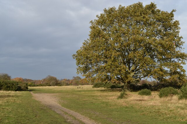
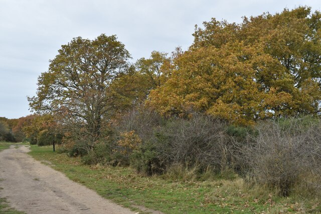
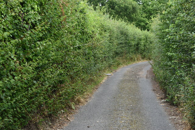
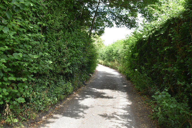
Joyden's Wood is a picturesque woodland located in the county of Kent, England. Covering an area of approximately 100 hectares, it is a popular destination for nature enthusiasts and outdoor lovers. The wood is situated between the towns of Bexley and Dartford, making it easily accessible for visitors from nearby areas.

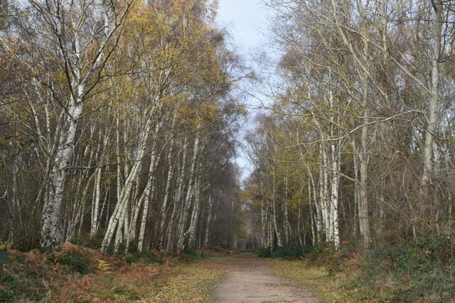
The woodland is known for its diverse range of flora and fauna, providing a habitat for various species of plants, birds, and animals. It boasts ancient oak and beech trees, creating a stunning canopy that provides shade during the summer months. The forest floor is adorned with a carpet of bluebells and wildflowers, adding to the natural beauty of the area.

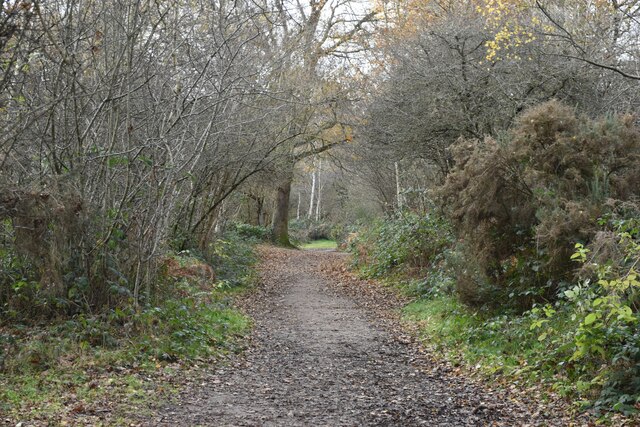
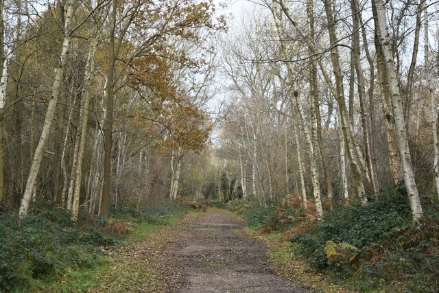
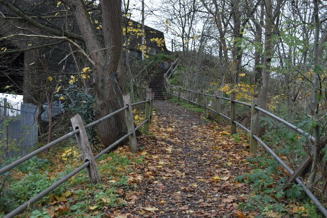
Joyden's Wood is also home to a network of walking trails and paths, allowing visitors to explore the wood at their own pace. These trails offer stunning views of the surrounding countryside and provide opportunities for peaceful walks, jogging, and cycling. Along the way, visitors may encounter various species of birds such as woodpeckers, nuthatches, and jays, as well as mammals like foxes and deer.

The wood is well-maintained, with designated picnic areas and benches scattered throughout, providing a perfect spot for families and friends to enjoy a picnic amidst the tranquil surroundings. Additionally, the wood offers educational opportunities with its nature reserves and information boards, allowing visitors to learn more about the local wildlife and conservation efforts.

Overall, Joyden's Wood is a serene and enchanting destination, offering a peaceful retreat from the hustle and bustle of everyday life. Its natural beauty and abundant wildlife make it a must-visit location for nature lovers and those seeking a tranquil escape in the heart of Kent.

If you have any feedback on the listing, please let us know in the comments section below.

Joyden's Wood Images

Images are sourced within 2km of 51.427116/0.16741325 or Grid Reference TQ5072. Thanks to Geograph Open Source API. All images are credited.

Tree and path on Dartford Heath
Tree-lined path on Dartford Heath
Path in the woods on Dartford Heath
Path on Dartford Heath, towards Old Bexley Lane
Path on Dartford Heath
London Loop footpath climbing A2 embankment The footpath uses the A2 bridge to cross the railway line.
London Loop footpath climbing A2 embankment
The footpath uses the A2 bridge to cross the railway line.
Birchwood Road towards Dartford
Birchwood Rd
Birchwood Rd
Stonehill Green
Stonehill Green
Stonehill Green
Stonehill Green
Stonehill Farm
Stonehill Farm
Barn, Stonehill Farm
The Forge
The Forge
Birchwood Park Golf Course Website: <span class="nowrap"><a title="www.birchwoodparkgc.co.uk/" rel="nofollow ugc noopener" href="http://www.birchwoodparkgc.co.uk/">Link</a><img style="margin-left:2px;" alt="External link" title="External link - shift click to open in new window" src="https://s1.geograph.org.uk/img/external.png" width="10" height="10"/></span>
Birchwood Park Golf Course
Website: LinkExternal link
Pond, Stonehill Green
Stonehill Green
Stonehill Green
Stonehill Green
Stonehill Green
Oast, Birchwood Park Golf Centre Buildings made to look like oast houses.
Oast, Birchwood Park Golf Centre
Buildings made to look like oast houses.
Show me another place!

Joyden's Wood is located at Grid Ref: TQ5072 (Lat: 51.427116, Lng: 0.16741325)

Administrative County: Kent

District: Dartford

Police Authority: Kent

What 3 Words

///duty.chew.tender. Near Bexley, London

Related Wikis

Joyden's Wood

Joyden's Wood is an area of ancient woodland that straddles the border between the London Borough of Bexley in South East London and the Borough of Dartford...

Maypole, Dartford

Maypole is a village in the Borough of Dartford in Kent, England. It is located north of Joyden's Wood and south-west of the town of Dartford. In the 2021...

Bowmans, Kent

Bowmans is a part of the town of Dartford in Kent, England. It is located to the south-west of the town centre.

Bexley Hospital

Bexley Hospital was a psychiatric hospital at Old Bexley Lane, Dartford Heath, Bexley, in the County of Kent. It operated between 19 September 1898 and...

Nearby Amenities

Located within 500m of 51.427116,0.16741325
Noexit: yes
Lat/Long: 51.4308828/0.164592
Turning Circle
Lat/Long: 51.4231314/0.1667554
Turning Circle
Lat/Long: 51.4233906/0.1714605
Turning Circle
Noexit: yes
Lat/Long: 51.4269442/0.1662344
Joydens Wood
Place: suburb
Lat/Long: 51.4269656/0.170417
Squires Way
Bus: yes
Public Transport: stop_position
Source: survey
Lat/Long: 51.4231071/0.1654962
Post Office
Bus: yes
Public Transport: stop_position
Source: survey
Lat/Long: 51.4265387/0.1671917
Post Box
Collection Times: Mo-Fr 16:45; Sa 11:15
Post Box Type: lamp
Ref: DA5 302
Royal Cypher: EIIR
Royal Cypher Wikidata: Q33102113
Lat/Long: 51.4267223/0.1670982
Barrier: kissing_gate
Foot: yes
Wheelchair: yes
Width: 1
Lat/Long: 51.4277781/0.1653007
Post Box
Operator: Royal Mail
Operator Wikidata: Q638098
Post Box Type: wall
Ref: DA2 381
Royal Cypher: EIIR
Royal Cypher Wikidata: Q33102113
Source: survey
Lat/Long: 51.4229216/0.165518
Post Box
Collection Times: Mo-Fr 09:00; Sa 07:00
Operator: Royal Mail
Operator Wikidata: Q638098
Post Box Type: pillar
Ref: DA5 193D
Royal Cypher: EIIR
Royal Cypher Wikidata: Q33102113
Survey Date: 2018-08-01
Lat/Long: 51.4291808/0.1697186
Noexit: yes
Lat/Long: 51.4308303/0.1648853
Tile Kiln Lane
Bus: yes
Public Transport: stop_position
Source: survey
Lat/Long: 51.4313305/0.1663396
Bus Stop
Tile Kiln Lane
Bench: no
Layby: no
Naptan AtcoCode: 490012585E
Naptan Bearing: E
Naptan CommonName: Tile Kiln Lane
Naptan Street: TILE KILN LANE
Public Transport: platform
Ref: 53253
Shelter: no
Source: naptan_import;survey
Tactile Paving: no
Lat/Long: 51.4313712/0.1664366
Bus Stop
Tile Kiln Lane
Bench: no
Layby: no
Naptan AtcoCode: 490012585W1
Naptan Bearing: W
Naptan CommonName: Tile Kiln Lane
Naptan Street: TILE KILN LANE
Public Transport: platform
Ref: 75795
Shelter: no
Source: naptan_import;survey
Tactile Paving: no
Lat/Long: 51.4312787/0.1662928
Bus Stop
Post Office
Bench: yes
Layby: no
Local Ref: adj
Naptan AtcoCode: 2400A020860A
Naptan Bearing: N
Naptan BusStopType: MKD
Naptan CommonName: Post Office
Naptan Indicator: adj
Naptan Landmark: Post Office
Naptan NaptanCode: kntawgag
Naptan RevisionNumber: 3
Naptan Status: act
Naptan Street: Summerhouse Drive
Note: name change to reflect sign.
Public Transport: platform
Ref: 56238
Shelter: yes
Source: naptan_import
Source Date: 2018-04-26
Tactile Paving: no
Lat/Long: 51.4265563/0.1670992
Bus Stop
Briar Road
Bench: no
Layby: no
Local Ref: adj
Naptan AtcoCode: 2400A020870A
Naptan Bearing: N
Naptan BusStopType: MKD
Naptan CommonName: Briar Road
Naptan Indicator: adj
Naptan Landmark: Briar Road
Naptan NaptanCode: kntawgaj
Naptan RevisionNumber: 3
Naptan Status: act
Naptan Street: Summerhouse Drive
Public Transport: platform
Ref: 47845
Shelter: no
Source: naptan_import
Source Date: 2018-04-26
Tactile Paving: no
Lat/Long: 51.4290731/0.168267
Bus Stop
Briar Road
Bench: no
Layby: no
Local Ref: opp
Naptan AtcoCode: 2400A020920A
Naptan Bearing: S
Naptan BusStopType: MKD
Naptan CommonName: Briar Road
Naptan Indicator: opp
Naptan Landmark: Briar Road
Naptan NaptanCode: kntawgam
Naptan RevisionNumber: 1
Naptan Status: act
Naptan Street: Summerhouse Drive
Public Transport: platform
Ref: 50194
Shelter: no
Source: naptan_import
Source Date: 2007-02-27
Tactile Paving: no
Lat/Long: 51.427932/0.1678971
Bus Stop
Post Office
Bench: no
Layby: no
Local Ref: opp
Naptan AtcoCode: 2400A020930A
Naptan Bearing: S
Naptan BusStopType: MKD
Naptan CommonName: Post Office
Naptan Indicator: opp
Naptan Landmark: Post Office
Naptan NaptanCode: kntawgap
Naptan RevisionNumber: 2
Naptan Status: act
Naptan Street: Summerhouse Drive
Note: name change to reflect sign.
Public Transport: platform
Ref: 77149
Shelter: no
Source: naptan_import
Source Date: 2014-01-27
Tactile Paving: no
Lat/Long: 51.4267926/0.1673984
Bus Stop
Squires Way
Bench: no
Layby: no
Local Ref: adj
Naptan AtcoCode: 2400A020940A
Naptan Bearing: S
Naptan BusStopType: MKD
Naptan CommonName: Squires Way
Naptan Indicator: adj
Naptan Landmark: Squires Way
Naptan NaptanCode: kntawgat
Naptan RevisionNumber: 2
Naptan Status: act
Naptan Street: Summerhouse Drive
Public Transport: platform
Ref: 71318
Shelter: no
Source: naptan_import
Source Date: 2018-04-26
Tactile Paving: no
Lat/Long: 51.4230884/0.1655655
Joydens Wood Launderette
Addr City: Dartford
Addr Street: Woodside Drive
Addr Substreet: Birchwood Parade
Opening Hours: Mo,Tu,Th,Fr 08:00-19:00; We 08:00-13:00; Sa,Su 08:00-18:00
Shop: laundry
Survey Date: 2021-11-01
Lat/Long: 51.4235539/0.1717742
Gray & Sons Butchers
Addr City: Dartford
Addr Postcode: DA2 7NJ
Addr Street: Woodside Drive
Addr Substreet: Birchwood Parade
Addr Unit: 9
Fhrs Id: 1357589
Opening Hours: Mo-Fr 08:00-17:00; Sa 08:00-16:00
Phone: +44 1322 558532
Shop: butcher
Source Addr: FHRS Open Data
Survey Date: 2021-11-01
Lat/Long: 51.4237265/0.1713913
Bicycle Parking
Summerhouse Drive Library
Capacity: 4
Lat/Long: 51.426166/0.1669183
The Times
Shop: newsagent
Lat/Long: 51.4267457/0.167019
Restaurant
Mahan Indian Takeaway
Addr Postcode: DA5 2EE
Addr Street: Summerhouse Drive
Cuisine: indian
Fhrs Id: 481749
Takeaway: only
Lat/Long: 51.4265889/0.1669501
Skin & Tonic
Shop: beauty
Lat/Long: 51.4266412/0.1669731
Mark Anthony Hair
Addr City: Dartford
Addr Street: Woodside Drive
Addr Substreet: Birchwood Parade
Phone: +44 1322 524251
Shop: hairdresser
Survey Date: 2021-11-01
Lat/Long: 51.4235884/0.1716976
J & R Food & Wine Ltd
Addr City: Dartford
Addr Postcode: DA2 7NJ
Addr Street: Woodside Drive
Addr Substreet: Birchwood Parade
Addr Unit: 7
Fhrs Id: 1407191
Shop: alcohol
Survey Date: 2021-11-01
Lat/Long: 51.4236575/0.1715445
The White Room
Addr City: Dartford
Addr Street: Woodside Drive
Addr Substreet: Birchwood Parade
Shop: beauty
Survey Date: 2021-11-01
Lat/Long: 51.423623/0.1716211
Dave's Corner Shop
Addr City: Dartford
Addr Housenumber: 10
Addr Postcode: DA2 7NJ
Addr Street: Woodside Drive
Addr Substreet: Birchwood Parade
Addr Unit: 10
Fhrs Id: 13364
Opening Hours: Mo-Sa 07:30-20:30; Su 08:00-16:00
Shop: convenience
Source Addr: FHRS Open Data
Survey Date: 2021-11-01
Lat/Long: 51.423761/0.1713147
PDS Communications
Addr City: Dartford
Addr Street: Woodside Drive
Addr Substreet: Birchwood Parade
Phone: +44 1322 526185
Shop: computer
Survey Date: 2021-11-01
Lat/Long: 51.423692/0.1714679
Post Office
Bus: yes
Public Transport: stop_position
Source: survey
Lat/Long: 51.4268093/0.1672966
Briar Road
Bus: yes
Public Transport: stop_position
Source: survey
Lat/Long: 51.4279554/0.1678378
Briar Road
Bus: yes
Public Transport: stop_position
Source: survey
Lat/Long: 51.4290551/0.168365
Tile Kiln Lane
Bus: yes
Public Transport: stop_position
Source: survey
Lat/Long: 51.4313203/0.166385
Louise Lambell Hair Design
Shop: hairdresser
Website: http://ww1.louiselambellhairdesign.co.uk
Lat/Long: 51.4267979/0.1670419
Generator Method: photovoltaic
Generator Orientation: 135
Generator Source: solar
Location: roof
Power: generator
Lat/Long: 51.4235503/0.1665291
Generator Method: photovoltaic
Generator Orientation: 100
Generator Source: solar
Location: roof
Power: generator
Lat/Long: 51.4240336/0.1657313
Generator Method: photovoltaic
Generator Orientation: 280
Generator Source: solar
Location: roof
Power: generator
Lat/Long: 51.4240468/0.1656611
Generator Method: photovoltaic
Generator Orientation: 90
Generator Source: solar
Location: roof
Power: generator
Lat/Long: 51.4238738/0.1661881
Generator Method: photovoltaic
Generator Orientation: 280
Generator Source: solar
Location: roof
Power: generator
Lat/Long: 51.4238687/0.1661147
Generator Method: photovoltaic
Generator Orientation: 100
Generator Source: solar
Location: roof
Power: generator
Lat/Long: 51.4272111/0.1695637
Coal tax post
Historic: boundary_stone
Inscription: ACT 24 & 25 VICT CAP 42
Material: i
Note: Coal tax boundary marker 208
Lat/Long: 51.4314425/0.1660164
Post Office
Joydens Wood Post Office
Addr City: Dartford
Addr Postcode: DA2 7NJ
Addr Street: Woodside Drive
Addr Substreet: Birchwood Parade
Addr Unit: 6
Opening Hours: Mo-Fr 06:30-19:00; Sa 07:00-19:00; Su 07:30-13:00
Ref Pol Id: 135640
Lat/Long: 51.4236417/0.1715213
Lavender Hill Florist
Shop: florist
Lat/Long: 51.4266934/0.166996
Roman Soldier
Artist Name: Peter Leadbeater
Artwork Type: statue
Material: wood
Tourism: artwork
Lat/Long: 51.4270903/0.1622797
Saxon Soldier
Artist Name: Peter Leadbeater
Artwork Type: statue
Material: wood
Tourism: artwork
Lat/Long: 51.4270467/0.1622555
Entrance: yes
Lat/Long: 51.4262143/0.1668565
The data included in this document is from www.openstreetmap.org. The data is made available under ODbL.

Have you been to Joyden's Wood?

Leave your review of Joyden's Wood below (or comments, questions and feedback).