Garry Claddach

Settlement in Inverness-shire

Scotland

Garry Claddach

Pony and ruin, Carinish
Pony and ruin, Carinish Credit: Hugh Venables

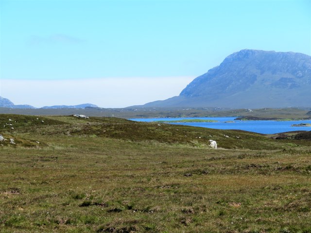
Garry Claddach is a small village located in Inverness-shire, Scotland. Situated on the western coast of the country, it lies on the shores of the Atlantic Ocean and offers picturesque views of the surrounding landscape. The village is nestled within the lush greenery of the Highlands, surrounded by rolling hills and stunning natural beauty.

With a population of around 200 residents, Garry Claddach is known for its tranquil and secluded atmosphere. The village is predominantly residential, with a few local businesses catering to the needs of the community. The main economic activities in the area are fishing, agriculture, and tourism.

Tourists are drawn to Garry Claddach for its unspoiled beaches, rugged cliffs, and peaceful atmosphere. The village serves as a base for outdoor enthusiasts who enjoy activities such as hiking, birdwatching, and fishing. The nearby Garry Claddach Forest offers scenic trails for exploring the area's diverse flora and fauna.

The village also boasts a rich history, with several historic sites nearby. Ruins of ancient castles and burial grounds can be found in the surrounding countryside, providing glimpses into the area's past.

While Garry Claddach may be small in size, its natural beauty and peaceful ambiance make it an appealing destination for those seeking a serene getaway amidst Scotland's stunning Highlands.

If you have any feedback on the listing, please let us know in the comments section below.

Garry Claddach Images

Images are sourced within 2km of 57.527744/-7.3165306 or Grid Reference NF8161. Thanks to Geograph Open Source API. All images are credited.

Pony and ruin, Carinish
End of the road at Àird Mhòr
House at Carinish
House at Carinish
Marshy area at Carinish Seemingly a naturally infilled loch.
Marshy area at Carinish
Seemingly a naturally infilled loch.
Outside Talla Chairinis, North Uist Outside a community hall
Outside Talla Chairinis, North Uist
Outside a community hall
Blar Chairinis Site of battle in 1601.
Blar Chairinis
Site of battle in 1601.
Stone barn at Carinish
The ruins of Trinity Temple (Teampull na Trianaid) According to the plaque "Medieval monastery and college of European significance, founded by Beathag, daughter of Somhairle (Somerled).  Enlarged about 1350 to 1390 by Amie Mic Ruarie, first wife of John, Lord of the Isles.  Reconstructed in the 16th century.  Destroyed after the reformation.  Later restored in the 19th century by Dotair Ban."
The ruins of Trinity Temple (Teampull na Trianaid)
According to the plaque "Medieval monastery and college of European significance, founded by Beathag, daughter of Somhairle (Somerled). Enlarged about 1350 to 1390 by Amie Mic Ruarie, first wife of John, Lord of the Isles. Reconstructed in the 16th century. Destroyed after the reformation. Later restored in the 19th century by Dotair Ban."
Field and houses at Carinish And also the site of Feith na Fala (The ditch of blood) - a battle waged in 1601 between the MacLeods and the MacDonalds.
Field and houses at Carinish
And also the site of Feith na Fala (The ditch of blood) - a battle waged in 1601 between the MacLeods and the MacDonalds.
Bagh a’ Ghriasaiche
Bagh a’ Ghriasaiche
Fèithe na Fala - The ditch of blood
View from Temple View Hotel Teampull na Trionaid is a ruined 13th-century church and seminary at Carinish, North Uist, Scotland. Amie mac Ruari is said to have rebuilt the church in the 14th century after her divorce from John of Islay, Lord of the Isles. The ruins are protected as a scheduled monument.
View from Temple View Hotel
Teampull na Trionaid is a ruined 13th-century church and seminary at Carinish, North Uist, Scotland. Amie mac Ruari is said to have rebuilt the church in the 14th century after her divorce from John of Islay, Lord of the Isles. The ruins are protected as a scheduled monument.
Closer to the temple The ruins of Trinity Temple (Teampull na Trianaid)
Closer to the temple
The ruins of Trinity Temple (Teampull na Trianaid)
Free Church, Cairinis Current OS maps show this as a church, but older versions show it as a pub, which was its original purpose. Enough said.
Free Church, Cairinis
Current OS maps show this as a church, but older versions show it as a pub, which was its original purpose. Enough said.
A not very useful gate A rusty old metal gate at the point where a fence once crossed the track.
A not very useful gate
A rusty old metal gate at the point where a fence once crossed the track.
Track above Loch Creag nan Speireag This track, which is indistinct in places, forms part of the Hebridean Way, a relatively new walking route through the Western Isles.
Track above Loch Creag nan Speireag
This track, which is indistinct in places, forms part of the Hebridean Way, a relatively new walking route through the Western Isles.
Cotton grass, Creag nan Speireag Looking over cotton grass towards Loch nan Speireag and the houses at Gearraidh Cladach.
Cotton grass, Creag nan Speireag
Looking over cotton grass towards Loch nan Speireag and the houses at Gearraidh Cladach.
East from Creag nan Speireag Some 200m from the Hebridean Way path which probably cuts the corner of this square and provides some very 'soft' walking over damp moors. This diversion to a low rise gives a view eastwards towards the oddly shaped Loch Carabhat and distant Eabhal.
East from Creag nan Speireag
Some 200m from the Hebridean Way path which probably cuts the corner of this square and provides some very 'soft' walking over damp moors. This diversion to a low rise gives a view eastwards towards the oddly shaped Loch Carabhat and distant Eabhal.
Show me another place!

Garry Claddach is located at Grid Ref: NF8161 (Lat: 57.527744, Lng: -7.3165306)

Unitary Authority: Na h-Eileanan an Iar

Police Authority: Highlands and Islands

Also known as: Gearraidh Cladach

What 3 Words

///otherwise.twinkled.reddish. Near Balivanich, Na h-Eileanan Siar

Related Wikis

Battle of Carinish

The Battle of Carinish was a Scottish clan battle fought in North Uist in 1601. It was part of a year of feuding between Clan MacLeod of Dunvegan and the...

Carinish

Carinish (Scottish Gaelic: Càirinis), is a hamlet on North Uist, in the Outer Hebrides, Scotland. It is in the south of the island, about two miles (three...

Teampull na Trionaid

Teampull na Trionaid ("trinity church") is a ruined 13th-century Augustinian nunnery at Carinish, on North Uist, in the Outer Hebrides of Scotland. �...

Bail' Iochdrach

Bail' Iochdrach or Baliochrach (Scottish Gaelic: Am Baile Ìochdrach) is a village on Benbecula in the Outer Hebrides, Scotland. Baliochrach is within the...

Baleshare

Baleshare (Scottish Gaelic: Baile Sear) is a flat tidal island in the Outer Hebrides of Scotland. Baleshare lies to the south-west of North Uist. Its economics...

Baile Glas

Baile Glas or Ballaglasa (Scottish Gaelic: Am Baile Glas) is a settlement on Grimsay in the Outer Hebrides, Scotland. Ballaglasa is within the parish of...

Fraoch-Eilean

Fraoch-eilean is a small island with an uncertain population north of Benbecula in the Outer Hebrides of Scotland. It is about 55 hectares (140 acres...

Uachdar

Uachdar (Scottish Gaelic: An t-Uachdar [ən̪ˠ ˈt̪ʰuəxkəɾ]) is a settlement on the Outer Hebridean Island of Benbecula. Uachdar is within the parish of South...

Nearby Amenities

Located within 500m of 57.527744,-7.3165306
Bus Stop
Carinish
Bus: yes
Naptan AtcoCode: 6010731585
Naptan Bearing: S
Naptan BusStopType: CUS
Naptan CommonName: Carinish
Naptan Indicator: School
Naptan Landmark: School car park
Naptan NaptanCode: 94723535
Naptan Street: School
Naptan Verified: no
Public Transport: platform
Source: naptan_import
Lat/Long: 57.5265676/-7.3155802
Post Box
Collection Times: Mo-Fr 14:00; Sa 09:30
Post Box Type: lamp
Royal Cypher: scottish_crown
Lat/Long: 57.5238889/-7.3144068
Telephone
Booth: KX100
Covered: booth
Payment Coins: yes
Lat/Long: 57.524198/-7.3145919
Bagh a' Ghriasaiche
Natural: bay
Lat/Long: 57.5235778/-7.3193622
Entrance: yes
Lat/Long: 57.5265036/-7.3164424
Power: pole
Lat/Long: 57.5283346/-7.3124287
Power: pole
Lat/Long: 57.5289365/-7.3119995
Power: pole
Lat/Long: 57.5293656/-7.3116615
Power: pole
Lat/Long: 57.5297904/-7.311396
Power: pole
Lat/Long: 57.5310504/-7.3119485
Power: pole
Lat/Long: 57.5316105/-7.3170313
Power: pole
Lat/Long: 57.5310763/-7.3164681
Power: pole
Lat/Long: 57.5305291/-7.3158512
Power: pole
Lat/Long: 57.5301187/-7.315363
Power: pole
Lat/Long: 57.5295427/-7.3147246
Power: pole
Lat/Long: 57.5243671/-7.3118305
Power: pole
Lat/Long: 57.5249489/-7.3120505
Power: pole
Lat/Long: 57.5256258/-7.3123455
Power: pole
Lat/Long: 57.5260376/-7.3125118
Power: pole
Lat/Long: 57.5264423/-7.3126701
Power: pole
Lat/Long: 57.5271307/-7.312941
Power: pole
Lat/Long: 57.5276001/-7.3131582
Power: pole
Lat/Long: 57.5289552/-7.3140702
Power: pole
Lat/Long: 57.5283994/-7.3134184
Power: pole
Lat/Long: 57.5278017/-7.3128042
Power: pole
Lat/Long: 57.5273971/-7.3123643
Power: pole
Lat/Long: 57.5265345/-7.3113853
Power: pole
Lat/Long: 57.5258749/-7.3105082
Power: pole
Lat/Long: 57.5252441/-7.3096123
Power: pole
Lat/Long: 57.5238376/-7.3126979
Power: pole
Lat/Long: 57.5244465/-7.3131966
Power: pole
Lat/Long: 57.5251515/-7.3137493
Power: pole
Lat/Long: 57.5255609/-7.31409
Power: pole
Lat/Long: 57.5256521/-7.315619
Power: pole
Lat/Long: 57.5255797/-7.3151398
Power: pole
Lat/Long: 57.5258614/-7.3166904
Power: pole
Lat/Long: 57.5262352/-7.3174481
Power: pole
Lat/Long: 57.5265303/-7.3180578
Power: pole
Lat/Long: 57.5273481/-7.3197322
Power: pole
Lat/Long: 57.5285744/-7.322253
Power: pole
Lat/Long: 57.5276362/-7.3203444
Power: pole
Lat/Long: 57.5282058/-7.3214947
Power: pole
Lat/Long: 57.5308709/-7.3178325
Power: pole
Lat/Long: 57.5236962/-7.3134847
Power: pole
Lat/Long: 57.5268112/-7.3186631
Barrier: cattle_grid
Lat/Long: 57.5242751/-7.3150783
Barrier: cattle_grid
Lat/Long: 57.5297409/-7.3172745
Power: pole
Lat/Long: 57.5310325/-7.3189248
Power: pole
Lat/Long: 57.5312355/-7.3202069
Power: pole
Lat/Long: 57.531368/-7.3210599
Power: pole
Lat/Long: 57.5276473/-7.3161439
Power: pole
Lat/Long: 57.5267445/-7.3157088
Power: pole
Lat/Long: 57.5272276/-7.3159291
Power: pole
Lat/Long: 57.5264301/-7.3155235
Power: pole
Lat/Long: 57.526035/-7.3157464
Man Made: mast
Tower Construction: freestanding
Tower Type: communication
Lat/Long: 57.5255758/-7.3111865
The data included in this document is from www.openstreetmap.org. The data is made available under ODbL.

Have you been to Garry Claddach?

Leave your review of Garry Claddach below (or comments, questions and feedback).