Bradley

Settlement in Lancashire Pendle

England

Bradley

Barrowford Reservoir, drained The reservoir, which serves the Leeds and Liverpool Canal rather than public water supply, was not empty because of the 2022 drought, but because it had been deliberately drained down in autumn 2021 for a year-long contract to stabilise the embankment. A short section of the canal nearby was also drained for maintenance at the same time.
Barrowford Reservoir, drained Credit: Stephen Craven

Bradley is a small village located in the county of Lancashire, England. It is situated in the West Lancashire district, approximately 6 miles south of the town of Skelmersdale. The village is surrounded by beautiful countryside and offers a tranquil setting for its residents.

With a population of around 1,500 people, Bradley has a close-knit community that prides itself on its friendly and welcoming atmosphere. The village is known for its picturesque landscapes, with rolling hills and open fields providing ample opportunities for outdoor activities such as hiking, cycling, and horse riding.

Bradley has a rich history, dating back to medieval times. The village features several historical landmarks, including St Mary's Church, which dates back to the 14th century. The church is known for its stunning architecture and stained glass windows, attracting visitors from near and far.

In terms of amenities, Bradley has a local primary school, providing education for children in the village and the surrounding areas. There is also a village hall that serves as a hub for community events and activities. However, for more extensive services, residents often travel to nearby towns such as Skelmersdale or Ormskirk.

The village enjoys good transport links, with regular bus services connecting it to the surrounding towns and villages. The nearest railway station is located in Burscough, approximately 4 miles away.

Overall, Bradley offers a peaceful and idyllic lifestyle for its residents, with its scenic surroundings and strong community spirit.

If you have any feedback on the listing, please let us know in the comments section below.

Bradley Images

Images are sourced within 2km of 53.840108/-2.2097885 or Grid Reference SD8638. Thanks to Geograph Open Source API. All images are credited.
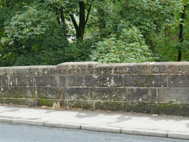
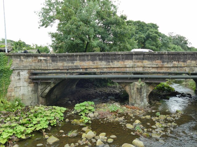
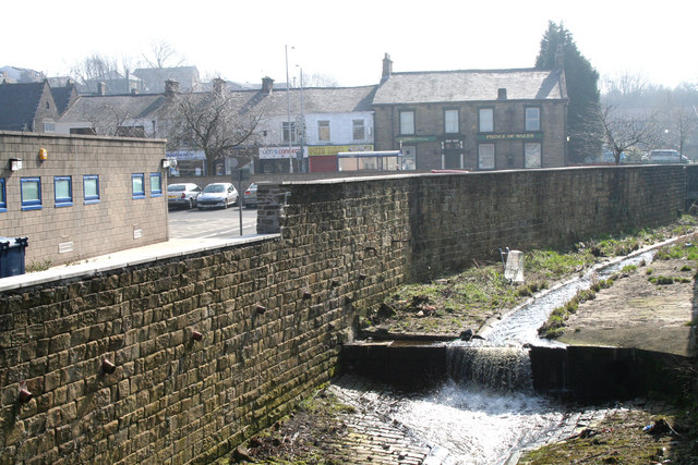
Barrowford Reservoir, drained The reservoir, which serves the Leeds and Liverpool Canal rather than public water supply, was not empty because of the 2022 drought, but because it had been deliberately drained down in autumn 2021 for a year-long contract to stabilise the embankment. A short section of the canal nearby was also drained for maintenance at the same time.
Barrowford Reservoir, drained
The reservoir, which serves the Leeds and Liverpool Canal rather than public water supply, was not empty because of the 2022 drought, but because it had been deliberately drained down in autumn 2021 for a year-long contract to stabilise the embankment. A short section of the canal nearby was also drained for maintenance at the same time.
Old mill, Gisburn Road, Higherford The 1912 map shows this as a corn mill. It's probably too high above the river to have been water powered. Now in private hands, a 2015 proposal for 'brownfield' development on the site was not approved. <a href="https://www.geograph.org.uk/photo/506484">SD8640 : Old mill on Gisburn Road, Barrowford</a> shows it from the other direction.
Old mill, Gisburn Road, Higherford
The 1912 map shows this as a corn mill. It's probably too high above the river to have been water powered. Now in private hands, a 2015 proposal for 'brownfield' development on the site was not approved. SD8640 : Old mill on Gisburn Road, Barrowford shows it from the other direction.
Former Catholic church, Gisburn Road, Higherford The name on the sign board is 'Parish of the Good Shepherd' but other contributors name the building itself as St Peter & St Paul's. A local website says that it was built from 1897, the first service registers being from 1902, but closed for worship in 2019. It appears no new use has been found yet.
Former Catholic church, Gisburn Road, Higherford
The name on the sign board is 'Parish of the Good Shepherd' but other contributors name the building itself as St Peter & St Paul's. A local website says that it was built from 1897, the first service registers being from 1902, but closed for worship in 2019. It appears no new use has been found yet.
Detail of Gisburn Road bridge, Higherford An inscription 'C C Higherford Bridge' and an OS cut benchmark (shown on the 1912 map as 437.9ft). It was built in 1807. See <a href="https://www.geograph.org.uk/photo/4956971">SD8640 : Higherford Bridge and Mill</a> for a side view of the bridge.
Detail of Gisburn Road bridge, Higherford
An inscription 'C C Higherford Bridge' and an OS cut benchmark (shown on the 1912 map as 437.9ft). It was built in 1807. See SD8640 : Higherford Bridge and Mill for a side view of the bridge.
Former cotton mill, Higherford Listed grade II (List entry 1271499) where it is dated to 'c.1844, incorporating elements of an earlier C19 mill, with further additions of 1882, and C20 alterations'. The main weaving shed seen in <a href="https://www.geograph.org.uk/photo/4957250">SD8640 : Grimshaw's (Higherford) Mill</a> is claimed to be the oldest surviving example of its kind. Note the iron beam and high level doorway, presumably for loading bales of cotton from road vehicles.
Former cotton mill, Higherford
Listed grade II (List entry 1271499) where it is dated to 'c.1844, incorporating elements of an earlier C19 mill, with further additions of 1882, and C20 alterations'. The main weaving shed seen in SD8640 : Grimshaw's (Higherford) Mill is claimed to be the oldest surviving example of its kind. Note the iron beam and high level doorway, presumably for loading bales of cotton from road vehicles.
Listed cottages, Foreside, Higherford Listed grade II (List entry 1073432) where the oldest is dated to 1755.
Listed cottages, Foreside, Higherford
Listed grade II (List entry 1073432) where the oldest is dated to 1755.
Crowtree Cottage, Foreside, Higherford Listed grade II (List entry 1273168) where it is dated to the mid-18th century. The large number of windows at first floor level suggests it was used for weaving.
Crowtree Cottage, Foreside, Higherford
Listed grade II (List entry 1273168) where it is dated to the mid-18th century. The large number of windows at first floor level suggests it was used for weaving.
Th' Owd Brig at Higherford This is described by Margaret Slack (Ref.1) as 'One of the most attractive packhorse bridges in [the Pennines] ...standing on the direct line of the Roman Road from Castercliffe to Ribchester. It was crossed by teams of packhorses bringing coal from near Gisburn and ... lime from Lothersdale.' She adds that the date of the bridge is not known with certainty, but probably late 16th century. 

The bridge crosses Pendle Water, draining the steep eastern scarp of that great hill, and subject to flash flooding; Slack relates a story that a bell used to hang from the bridge that rang a warning when water approached flood level.

Listed grade II *(List entry 1273194) and a Scheduled Monument. Originally it would have had no, or very low, parapets to allow ponies with low-hanging panniers to cross; the present parapets were added in 1815.

(1) 'The Bridges of Lancashire and Yorkshire', Margaret Slack, 1986.
Th' Owd Brig at Higherford
This is described by Margaret Slack (Ref.1) as 'One of the most attractive packhorse bridges in [the Pennines] ...standing on the direct line of the Roman Road from Castercliffe to Ribchester. It was crossed by teams of packhorses bringing coal from near Gisburn and ... lime from Lothersdale.' She adds that the date of the bridge is not known with certainty, but probably late 16th century. The bridge crosses Pendle Water, draining the steep eastern scarp of that great hill, and subject to flash flooding; Slack relates a story that a bell used to hang from the bridge that rang a warning when water approached flood level. Listed grade II *(List entry 1273194) and a Scheduled Monument. Originally it would have had no, or very low, parapets to allow ponies with low-hanging panniers to cross; the present parapets were added in 1815. (1) 'The Bridges of Lancashire and Yorkshire', Margaret Slack, 1986.
Gisburn Road bridge, Higherford This road bridge over Pendle Water was erected in 1807 to supersede the old packhorse bridge, which still stands but closed to motor traffic <a href="https://www.geograph.org.uk/photo/7265480">SD8640 : Th' Owd Brig at Higherford</a>.
Gisburn Road bridge, Higherford
This road bridge over Pendle Water was erected in 1807 to supersede the old packhorse bridge, which still stands but closed to motor traffic SD8640 : Th' Owd Brig at Higherford.
The Old Bridge Inn, Higherford Actually close to the 'new' bridge, not the old one <a href="https://www.geograph.org.uk/photo/7265480">SD8640 : Th' Owd Brig at Higherford</a>.
The Old Bridge Inn, Higherford
Actually close to the 'new' bridge, not the old one SD8640 : Th' Owd Brig at Higherford.
Former Methodist Sunday School, Higherford Dated 1834, in residential use since 1972 (source: <span class="nowrap"><a title="https://www.flickr.com/photos/rossendalewadey/5885068439" rel="nofollow ugc noopener" href="https://www.flickr.com/photos/rossendalewadey/5885068439">Link</a><img style="margin-left:2px;" alt="External link" title="External link - shift click to open in new window" src="https://s1.geograph.org.uk/img/external.png" width="10" height="10"/></span> ). An early 20th century map shows a tram terminus outside; the tramway from Nelson opened in the early years of the century and closed in 1934.
Former Methodist Sunday School, Higherford
Dated 1834, in residential use since 1972 (source: LinkExternal link ). An early 20th century map shows a tram terminus outside; the tramway from Nelson opened in the early years of the century and closed in 1934.
Former Methodist Sunday School, Higherford - datestone Wesleyan Methodist Sunday School Built by Subscription AD 1834. See <a href="https://www.geograph.org.uk/photo/7265486">SD8640 : Former Methodist Sunday School, Higherford</a> for context.
Former Methodist Sunday School, Higherford - datestone
Wesleyan Methodist Sunday School Built by Subscription AD 1834. See SD8640 : Former Methodist Sunday School, Higherford for context.
Fold, Gisburn Road, Higherford Mid-18th century stone cottages, grade II listed (list entry 1073435).
Fold, Gisburn Road, Higherford
Mid-18th century stone cottages, grade II listed (list entry 1073435).
A drained Barrowford Reservoir Essential maintenance work was being done on the reservoir embankments and re-proofing. The dam feeds the Leeds & Liverpool Canal.
A drained Barrowford Reservoir
Essential maintenance work was being done on the reservoir embankments and re-proofing. The dam feeds the Leeds & Liverpool Canal.
Greenfield Road Local Nature Reserve The path forms part of the Colne Valley Greenway (cycle route).
Greenfield Road Local Nature Reserve
The path forms part of the Colne Valley Greenway (cycle route).
Sewage works between Nelson and Colne Seen from the Colne Valley Greenway.
Sewage works between Nelson and Colne
Seen from the Colne Valley Greenway.
Houses on Greenfield Road A fellow contributor has researched the history of these houses thoroughly <a href="https://www.geograph.org.uk/photo/1759330">SD8739 : Colne:  Western end of Greenfield Road</a>.
Houses on Greenfield Road
A fellow contributor has researched the history of these houses thoroughly SD8739 : Colne: Western end of Greenfield Road.
Drained canal at Barrowford Locks This is not a result of the 2022 drought, but ongoing civil engineering works. <a href="https://www.geograph.org.uk/photo/6075454">SD8639 : Bridge 142A, Leeds & Liverpool Canal</a> shows the same stretch with a normal water level.
Drained canal at Barrowford Locks
This is not a result of the 2022 drought, but ongoing civil engineering works. SD8639 : Bridge 142A, Leeds & Liverpool Canal shows the same stretch with a normal water level.
Show me another place!

Bradley is located at Grid Ref: SD8638 (Lat: 53.840108, Lng: -2.2097885)

Administrative County: Lancashire

District: Pendle

Police Authority: Lancashire

What 3 Words

///exclusive.betrayed.slices. Near Barrowford, Lancashire

Nearby Locations

Bradley

Related Wikis

Pendle Community Hospital

Pendle Community Hospital is a community hospital in Nelson, Lancashire. It is managed by East Lancashire Hospitals NHS Trust. == History == The Pendle...

Walverden Water

Walverden Water is a minor river in Lancashire, England. It is approximately 2.6 miles (4.2 km) long and has a catchment area of 5.04 square miles (1,304...

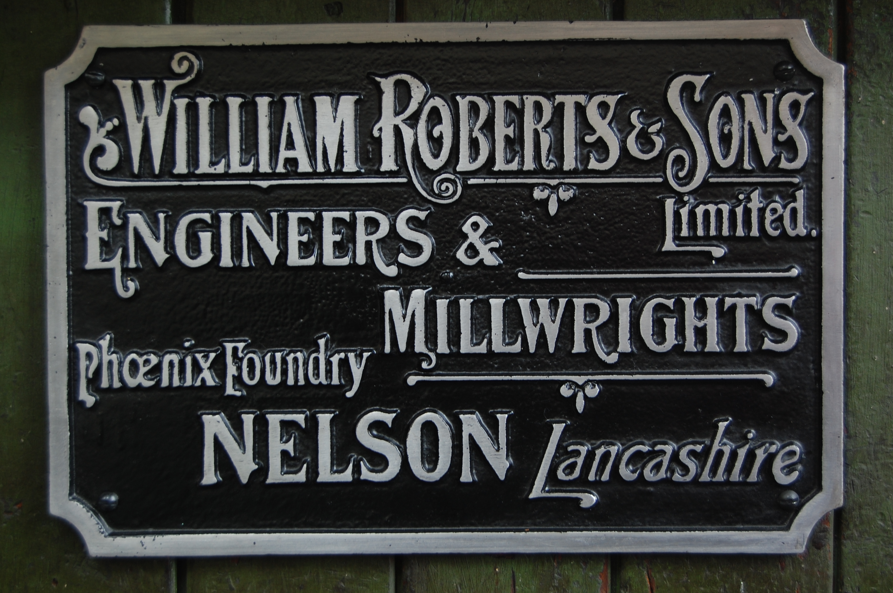
William Roberts & Co of Nelson

William Roberts and Company (later William Roberts and Sons) of Phoenix Foundry in Nelson, Lancashire, England, produced many of the steam engines that...

Nelson Town Hall

Nelson Town Hall is a municipal building in Market Square, Nelson, Lancashire, England. The building is the headquarters for both Pendle Borough Council...

Nearby Amenities

Located within 500m of 53.840108,-2.2097885
Nelson
Place: town
Wikidata: Q1857774
Wikipedia: en:Nelson, Lancashire
Lat/Long: 53.8363428/-2.2116469
Mini Roundabout
Lat/Long: 53.8422202/-2.204731
Give Way
Direction: backward
Lat/Long: 53.8404705/-2.2057989
Traffic Signals
Lat/Long: 53.8371742/-2.2131345
Mini Roundabout
Direction: clockwise
Lat/Long: 53.8362345/-2.2124363
Traffic Signals
Traffic Signals: crossing
Lat/Long: 53.8422539/-2.2162506
Mini Roundabout
Direction: clockwise
Lat/Long: 53.8372096/-2.2059576
Crossing Barrier: double_half
Crossing Light: yes
Railway: level_crossing
Lat/Long: 53.8379719/-2.2078004
Mini Roundabout
Lat/Long: 53.8410622/-2.2147232
Mini Roundabout
Lat/Long: 53.8430203/-2.2074183
Bradley
Place: suburb
Source: OS_OpenData_StreetView
Lat/Long: 53.8399936/-2.208961
Mini Roundabout
Direction: clockwise
Lat/Long: 53.8404039/-2.205823
Fast Food
Santas Pizza
Lat/Long: 53.8399977/-2.2062435
Marketplace
Admirals market
Lat/Long: 53.8366619/-2.2135906
Traffic Signals
Traffic Signals: crossing
Lat/Long: 53.8421322/-2.2162256
Entrance: yes
Lat/Long: 53.8386441/-2.2110207
Post Box
Collection Times: Mo-Fr 09:00, Sa 07:00
Operator: Royal Mail
Post Box Type: pillar
Ref: BB9 111D
Royal Cypher: EIIR
Royal Cypher Wikidata: Q33102113
Lat/Long: 53.8401868/-2.2139325
Bus Stop
Wavelengths
Bench: no
Lit: no
Public Transport: platform
Shelter: yes
Tactile Paving: no
Lat/Long: 53.8379163/-2.2116588
Bus Stop
Wavelengths
Bench: yes
Lit: no
Naptan AtcoCode: 2500LAA00226
Naptan NaptanCode: langtpam
Public Transport: platform
Shelter: yes
Tactile Paving: no
Lat/Long: 53.8375812/-2.2121111
Bus Stop
Seldon Street
Bench: yes
Naptan AtcoCode: 2500DCL5676
Naptan NaptanCode: landmjam
Public Transport: platform
Shelter: yes
Tactile Paving: no
Lat/Long: 53.8393073/-2.2082756
Bus Stop
Seldon Street
Bench: yes
Public Transport: platform
Shelter: yes
Tactile Paving: yes
Lat/Long: 53.8389343/-2.2089708
Bus Stop
Hilldrop Road
Bench: no
Public Transport: platform
Shelter: no
Tactile Paving: no
Lat/Long: 53.8399751/-2.2065184
Bus Stop
Hilldrop Road
Bench: yes
Naptan AtcoCode: 2500DCL5678
Naptan NaptanCode: landmjat
Public Transport: platform
Shelter: yes
Tactile Paving: no
Lat/Long: 53.840658/-2.2058429
Bus Stop
Colbran Street
Naptan AtcoCode: 2500DCL5679
Naptan NaptanCode: landmjaw
Public Transport: platform
Lat/Long: 53.8426037/-2.204306
Bus Stop
Reedyford Grove
Bench: no
Bin: no
Lit: no
Naptan AtcoCode: 2500DCL5680
Naptan NaptanCode: landmjdg
Public Transport: platform
Shelter: no
Tactile Paving: no
Lat/Long: 53.8426872/-2.2040001
Bus Stop
New Scotland Road
Bench: yes
Bin: no
Lit: no
Naptan AtcoCode: 2500LAA07247
Naptan NaptanCode: lanjadgm
Public Transport: platform
Shelter: yes
Tactile Paving: no
Lat/Long: 53.8378772/-2.2136948
Bus Stop
New Scotland Road
Bench: yes
Bin: no
Lit: no
Naptan AtcoCode: 2500DCL5664
Naptan NaptanCode: landmgtp
Public Transport: platform
Shelter: yes
Tactile Paving: no
Lat/Long: 53.8378495/-2.2133216
Bus Stop
Pendle Street
Bench: no
Bin: no
Lit: yes
Naptan AtcoCode: 2500LAA08224
Naptan NaptanCode: lanjwamd
Public Transport: platform
Shelter: no
Tactile Paving: no
Lat/Long: 53.8383823/-2.2149274
Bus Stop
North Street
Bench: no
Naptan AtcoCode: 2500LAA08225
Naptan NaptanCode: lanjwamg
Public Transport: platform
Shelter: no
Tactile Paving: no
Lat/Long: 53.8389473/-2.2143588
Bus Stop
Morrisons
Bench: yes
Lit: no
Public Transport: platform
Shelter: yes
Tactile Paving: no
Lat/Long: 53.8390582/-2.2164832
Bus Stop
Morrisons
Bench: yes
Lit: no
Naptan AtcoCode: 25001909
Naptan NaptanCode: lanatjda
Public Transport: platform
Shelter: yes
Tactile Paving: no
Lat/Long: 53.8390738/-2.2166658
Bus Stop
East Street
Naptan AtcoCode: 2500LAA07248
Naptan NaptanCode: lanjadgp
Public Transport: platform
Lat/Long: 53.8408169/-2.2145642
Bus Stop
Rook Street
Naptan AtcoCode: 2500LAA07249
Naptan NaptanCode: lanjadgt
Public Transport: platform
Lat/Long: 53.841486/-2.2150527
Bus Stop
Canal Bridge
Public Transport: platform
Lat/Long: 53.8420575/-2.2161227
Bus Stop
Raglan Street
Bench: no
Lit: no
Naptan AtcoCode: 2500DCL5668
Naptan NaptanCode: landmgwg
Public Transport: platform
Shelter: no
Tactile Paving: no
Lat/Long: 53.8382424/-2.216279
Bus Stop
Warde Street
Bench: no
Bin: no
Lit: no
Naptan AtcoCode: 2500IMG2724
Naptan NaptanCode: langdtmt
Public Transport: platform
Shelter: no
Tactile Paving: no
Lat/Long: 53.8364585/-2.208409
Bus Stop
Bracewell Street
Bench: no
Bin: no
Lit: yes
Naptan AtcoCode: 2500IMG2723
Naptan NaptanCode: langdtmp
Public Transport: platform
Shelter: no
Tactile Paving: no
Lat/Long: 53.8366559/-2.2076814
Bus Stop
Netherfield Road
Bench: no
Bin: no
Lit: no
Naptan AtcoCode: 2500IMG2722
Naptan NaptanCode: langdtmj
Public Transport: platform
Shelter: no
Tactile Paving: no
Lat/Long: 53.8371549/-2.2054962
Bus Stop
Netherfield Road
Bench: yes
Bin: no
Lit: no
Public Transport: platform
Shelter: yes
Tactile Paving: no
Lat/Long: 53.837111/-2.2057029
Crossing
Crossing: zebra
Crossing Island: no
Tactile Paving: yes
Lat/Long: 53.8382042/-2.2107788
Power: tower
Lat/Long: 53.8435549/-2.2142762
Give Way
Direction: backward
Lat/Long: 53.8404232/-2.2058943
Give Way
Direction: forward
Lat/Long: 53.8403526/-2.2058881
Give Way
Direction: backward
Lat/Long: 53.8403894/-2.2057462
Give Way
Direction: forward
Lat/Long: 53.8404302/-2.205503
Traffic Signals
Traffic Signals: signal
Lat/Long: 53.8372506/-2.2130558
Crossing
Button Operated: yes
Crossing: traffic_signals
Kerb: lowered
Tactile Paving: yes
Traffic Signals Sound: yes
Traffic Signals Vibration: yes
Lat/Long: 53.8371172/-2.2129777
Crossing
Button Operated: yes
Crossing: traffic_signals
Crossing Ref: puffin
Kerb: lowered
Tactile Paving: yes
Traffic Signals Sound: yes
Traffic Signals Vibration: yes
Lat/Long: 53.8370193/-2.2130389
Crossing
Crossing: traffic_signals
Crossing Ref: toucan
Kerb: lowered
Tactile Paving: yes
Lat/Long: 53.8373008/-2.2132097
Crossing
Crossing: traffic_signals
Crossing Ref: toucan
Kerb: lowered
Tactile Paving: yes
Lat/Long: 53.8373226/-2.2131006
Crossing
Crossing: traffic_signals
Crossing Ref: toucan
Kerb: lowered
Tactile Paving: yes
Lat/Long: 53.8373826/-2.2129785
Crossing
Button Operated: yes
Crossing: traffic_signals
Crossing Ref: pelican
Kerb: lowered
Tactile Paving: yes
Traffic Signals Sound: yes
Traffic Signals Vibration: yes
Lat/Long: 53.837293/-2.212957
Crossing
Button Operated: yes
Crossing: traffic_signals
Crossing Ref: pelican
Kerb: lowered
Tactile Paving: yes
Traffic Signals Sound: yes
Traffic Signals Vibration: yes
Lat/Long: 53.8372604/-2.2128211
Crossing
Button Operated: yes
Crossing: traffic_signals
Crossing Ref: pelican
Kerb: lowered
Tactile Paving: yes
Traffic Signals Sound: yes
Traffic Signals Vibration: yes
Lat/Long: 53.8381033/-2.2136867
Crossing
Button Operated: yes
Crossing: traffic_signals
Crossing Ref: pelican
Kerb: lowered
Tactile Paving: yes
Traffic Signals Sound: yes
Traffic Signals Vibration: yes
Lat/Long: 53.838122/-2.2135904
Crossing
Crossing: zebra
Crossing Island: no
Kerb: lowered
Tactile Paving: yes
Lat/Long: 53.8400611/-2.2139182
Crossing
Crossing: zebra
Kerb: lowered
Tactile Paving: yes
Lat/Long: 53.8423472/-2.2051425
Crossing
Crossing: traffic_signals
Crossing Ref: puffin
Kerb: lowered
Tactile Paving: yes
Lat/Long: 53.8415688/-2.2053072
Bicycle Parking
Bicycle Parking: stands
Capacity: 4
Covered: no
Fee: no
Lat/Long: 53.8371482/-2.2133461
Bicycle Parking
Bicycle Parking: stands
Capacity: 6
Covered: no
Fee: no
Lat/Long: 53.8370589/-2.2132178
Bicycle Parking
Bicycle Parking: stands
Capacity: 8
Covered: yes
Fee: no
Lat/Long: 53.8380978/-2.2133316
Khon Kaen Thai Therapy
Addr City: Nelson
Addr Housenumber: 159
Addr Postcode: BB9 9XL
Addr Street: Leeds Road
Shop: massage
Lat/Long: 53.8401325/-2.2065401
Barrier: bollard
Bollard: fixed
Lat/Long: 53.8369611/-2.2051112
Barrier: bollard
Lat/Long: 53.8401313/-2.2140632
Barrier: yes
Lat/Long: 53.8414014/-2.2154726
The Shuttle
Artist Name: Dave Palmer
Artwork Type: sculpture
Inscription: "Wen yer can si pendle hill, it's bahn ter rain. an w'en yer cahn't, it is"
Material: steel
Tourism: artwork
Lat/Long: 53.8366677/-2.2144894
Clock
Nelson Town Clock
Display: analog
Faces: 4
Visibility: area
Lat/Long: 53.8368465/-2.2141997
Crossing
Crossing: zebra
Crossing Island: no
Tactile Paving: yes
Lat/Long: 53.8370549/-2.2052532
Crossing
Crossing: traffic_signals
Crossing Island: no
Crossing Ref: pelican
Tactile Paving: yes
Lat/Long: 53.840258/-2.2060083
Generator Method: photovoltaic
Generator Output Electricity: yes
Generator Source: solar
Generator Type: solar_photovoltaic_panel
Power: generator
Lat/Long: 53.8364207/-2.2092628
Generator Method: photovoltaic
Generator Output Electricity: yes
Generator Source: solar
Generator Type: solar_photovoltaic_panel
Power: generator
Lat/Long: 53.8381015/-2.2084839
Generator Method: photovoltaic
Generator Output Electricity: yes
Generator Source: solar
Generator Type: solar_photovoltaic_panel
Power: generator
Lat/Long: 53.8381115/-2.2091402
Generator Method: photovoltaic
Generator Output Electricity: yes
Generator Source: solar
Generator Type: solar_photovoltaic_panel
Power: generator
Lat/Long: 53.8381397/-2.209037
Generator Method: photovoltaic
Generator Output Electricity: yes
Generator Source: solar
Generator Type: solar_photovoltaic_panel
Power: generator
Lat/Long: 53.8382479/-2.208923
Generator Method: photovoltaic
Generator Output Electricity: yes
Generator Source: solar
Generator Type: solar_photovoltaic_panel
Power: generator
Lat/Long: 53.8382761/-2.2088367
Generator Method: photovoltaic
Generator Output Electricity: yes
Generator Source: solar
Generator Type: solar_photovoltaic_panel
Power: generator
Lat/Long: 53.838297/-2.2087381
Generator Method: photovoltaic
Generator Output Electricity: yes
Generator Source: solar
Generator Type: solar_photovoltaic_panel
Power: generator
Lat/Long: 53.838337/-2.2086488
Generator Method: photovoltaic
Generator Output Electricity: yes
Generator Source: solar
Generator Type: solar_photovoltaic_panel
Power: generator
Lat/Long: 53.8380652/-2.20841
Generator Method: photovoltaic
Generator Output Electricity: yes
Generator Source: solar
Generator Type: solar_photovoltaic_panel
Power: generator
Lat/Long: 53.8379815/-2.2082868
Generator Method: photovoltaic
Generator Output Electricity: yes
Generator Source: solar
Generator Type: solar_photovoltaic_panel
Power: generator
Lat/Long: 53.8379361/-2.2082267
Generator Method: photovoltaic
Generator Output Electricity: yes
Generator Source: solar
Generator Type: solar_photovoltaic_panel
Power: generator
Lat/Long: 53.8378643/-2.2087289
Generator Method: photovoltaic
Generator Output Electricity: yes
Generator Source: solar
Generator Type: solar_photovoltaic_panel
Power: generator
Lat/Long: 53.8378252/-2.2086596
Generator Method: photovoltaic
Generator Output Electricity: yes
Generator Source: solar
Generator Type: solar_photovoltaic_panel
Power: generator
Lat/Long: 53.837797/-2.2085718
Generator Method: photovoltaic
Generator Output Electricity: yes
Generator Source: solar
Generator Type: solar_photovoltaic_panel
Power: generator
Lat/Long: 53.837757/-2.208504
Parking Space
Capacity: 1
Parking Space: disabled
Lat/Long: 53.8364365/-2.2089168
Parking Space
Capacity: 1
Parking Space: disabled
Lat/Long: 53.8365881/-2.2090639
Generator Method: photovoltaic
Generator Output Electricity: yes
Generator Source: solar
Generator Type: solar_photovoltaic_panel
Power: generator
Lat/Long: 53.8361738/-2.2078394
Barrier: bollard
Lat/Long: 53.8388951/-2.209343
Crossing
Lat/Long: 53.8377031/-2.2119625
The data included in this document is from www.openstreetmap.org. The data is made available under ODbL.

Have you been to Bradley?

Leave your review of Bradley below (or comments, questions and feedback).