West Point

Coastal Feature, Headland, Point in Glamorgan

Wales

West Point

St Mary's Well Bay just west of Lavernock Point The foreshore here is like layers of sloping pavement where the thin strata of Blue Lias limestone overlay one another.
St Mary's Well Bay just west of Lavernock Point Credit: Penny Mayes

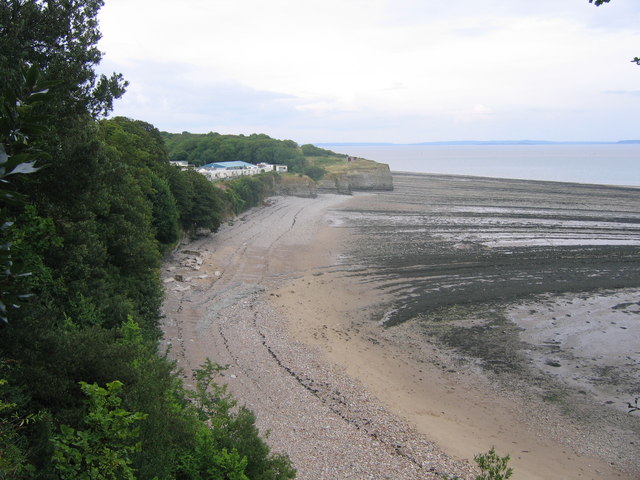
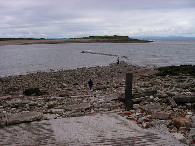
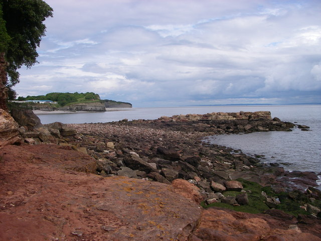
West Point is a prominent coastal feature located in Glamorgan, Wales. It is a headland that extends out into the Bristol Channel, forming a distinct point along the coastline. With its stunning views and rugged beauty, West Point is a popular destination for locals and tourists alike.

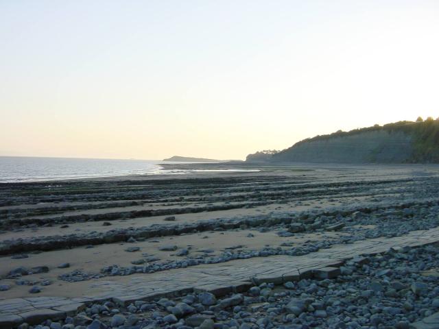
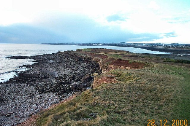
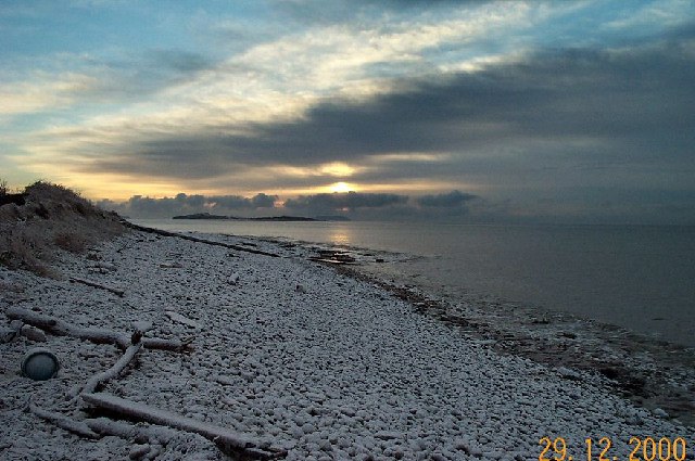
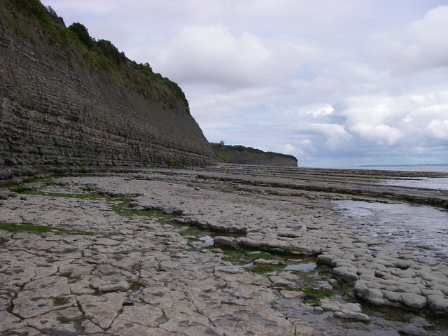
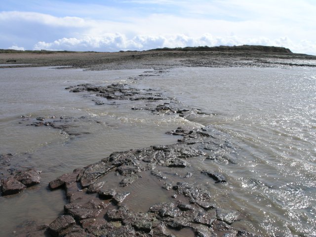
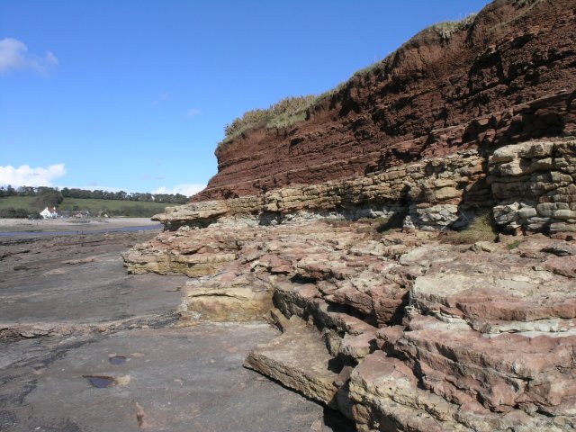
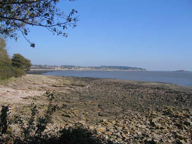
Situated at the southernmost tip of Glamorgan, West Point offers sweeping views of the surrounding coastline and the vast expanse of the Bristol Channel. The headland is characterized by steep cliffs that drop dramatically into the sea below, creating a dramatic and picturesque landscape. The cliffs are made up of layers of sedimentary rock, giving them a unique and distinctive appearance.

The area surrounding West Point is rich in biodiversity, with a variety of plant and animal species calling it home. The headland provides a habitat for numerous seabirds, including gulls, cormorants, and puffins, making it a haven for birdwatchers. The adjacent waters are also teeming with marine life, making it a popular spot for fishing and diving enthusiasts.

In addition to its natural beauty, West Point holds historical significance. During World War II, it served as a strategic lookout point for Allied forces, providing surveillance of enemy activity in the Bristol Channel. Today, remnants of military structures can still be seen, adding to the area's historical appeal.

Overall, West Point is a captivating coastal feature that offers breathtaking views, abundant wildlife, and a glimpse into the region's history. Its rugged cliffs, diverse ecosystem, and historical significance make it a must-visit destination for those seeking to explore the natural wonders of Glamorgan.

If you have any feedback on the listing, please let us know in the comments section below.

West Point Images

Images are sourced within 2km of 51.39586/-3.2032126 or Grid Reference ST1667. Thanks to Geograph Open Source API. All images are credited.

St Mary's Well Bay just west of Lavernock Point The foreshore here is like layers of sloping pavement where the thin strata of Blue Lias limestone overlay one another.
St Mary's Well Bay just west of Lavernock Point
The foreshore here is like layers of sloping pavement where the thin strata of Blue Lias limestone overlay one another.
Sully Island The west view taken from on top of this small island. The rock strata are gently inclining. The water is part of the Bristol Channel and is pretty muddy! In the distance lies Barry.
Sully Island
The west view taken from on top of this small island. The rock strata are gently inclining. The water is part of the Bristol Channel and is pretty muddy! In the distance lies Barry.
Sully Beach A midwinter view of Sully Beach. The island is in the mid distance.
Sully Beach
A midwinter view of Sully Beach. The island is in the mid distance.
Sully Houses An example of one of the residential streets of Sully. Just behind these houses lies the Bristol Channel.
Sully Houses
An example of one of the residential streets of Sully. Just behind these houses lies the Bristol Channel.
Sully High Street The high street is the main Penarth to Barry Road. On either side of this road lie the residential streets of the ribbon development that comprises a large part of Sully.
Sully High Street
The high street is the main Penarth to Barry Road. On either side of this road lie the residential streets of the ribbon development that comprises a large part of Sully.
The edge of Sully Looking back at Sully from a field near Cog.
The edge of Sully
Looking back at Sully from a field near Cog.
St. Mary's Well Bay Low tide at St. Mary's Well Bay, looking across to the caravan park above the bay
St. Mary's Well Bay
Low tide at St. Mary's Well Bay, looking across to the caravan park above the bay
Ty Hafan, Children's Hospice for Wales This new facility is set in extensive park like grounds overlooking the sea.
Ty Hafan, Children's Hospice for Wales
This new facility is set in extensive park like grounds overlooking the sea.
The Sand Spit St Mary's Well Bay
Shingle spit reaching out to Sully Island View across from Swanbridge at half tide towards this small island composed of warm orange Triassic sandstone.  The mainland coast is undergoing active erosion.
Shingle spit reaching out to Sully Island
View across from Swanbridge at half tide towards this small island composed of warm orange Triassic sandstone. The mainland coast is undergoing active erosion.
Lower Lias cliffs west of Lavernock Point Tide and waves have generated a coastal rock platform from the mudstones and limestones of the Lower Lias whilst the cliff retreats inland at the expense of the S & W Wales Wildlife Trust nature reserve atop it.
Lower Lias cliffs west of Lavernock Point
Tide and waves have generated a coastal rock platform from the mudstones and limestones of the Lower Lias whilst the cliff retreats inland at the expense of the S & W Wales Wildlife Trust nature reserve atop it.
St Mary's Well Bay This truly is a bay of two halves - the west side (foreground) is carved from warm-coloured Triassic sandstones which dip moderately steeply southwards.  The far side (east) is backed by cliffs of the Lower Lias limestones and mudstones which have a 'cold' feel to them.  Ball Rock is seen in the middle foreground at high tide.
St Mary's Well Bay
This truly is a bay of two halves - the west side (foreground) is carved from warm-coloured Triassic sandstones which dip moderately steeply southwards. The far side (east) is backed by cliffs of the Lower Lias limestones and mudstones which have a 'cold' feel to them. Ball Rock is seen in the middle foreground at high tide.
Causeway revealed! You feel like Moses parting the red sea if you stand at the edge of the causeway to Sully Island as the tide rapidly recedes - within the space of a minute this transformed from a body of water to something that could be crossed using walking boots rather than wellingtons!  The picture was taken about half way through this transformation.

For some strange reason the water flow was going in the opposite direction to the obvious local water flow at this point - I guess this was down to wind direction and wave flow at the minute or so we were there.
Causeway revealed!
You feel like Moses parting the red sea if you stand at the edge of the causeway to Sully Island as the tide rapidly recedes - within the space of a minute this transformed from a body of water to something that could be crossed using walking boots rather than wellingtons! The picture was taken about half way through this transformation. For some strange reason the water flow was going in the opposite direction to the obvious local water flow at this point - I guess this was down to wind direction and wave flow at the minute or so we were there.
Vivid changes in rock colour This area is a geologist's dream - and Sully Island is so in a microcosm - the island's western tip looks like a blancmange with the number of rock types that can be observed in such a small rock edge.
Vivid changes in rock colour
This area is a geologist's dream - and Sully Island is so in a microcosm - the island's western tip looks like a blancmange with the number of rock types that can be observed in such a small rock edge.
Victorian sea wreck You could be forgiven for ignoring this when visiting the island as a relatively modern sea wreck - but on closer inspection this is fascinating - the ship was wrecked over 100 years ago - yet the craft work of the builders can still be seen in detail if you examine what remains.
Victorian sea wreck
You could be forgiven for ignoring this when visiting the island as a relatively modern sea wreck - but on closer inspection this is fascinating - the ship was wrecked over 100 years ago - yet the craft work of the builders can still be seen in detail if you examine what remains.
Bow of a sunken Victorian vessel It's amazing how much can survive over 100 years of seas and the 2nd biggest tidal range in the world.

You can still run your fingers over timbers that were put in place by craftsmen and ship builders on this wreck that is submerged for most of the day, twice.
Bow of a sunken Victorian vessel
It's amazing how much can survive over 100 years of seas and the 2nd biggest tidal range in the world. You can still run your fingers over timbers that were put in place by craftsmen and ship builders on this wreck that is submerged for most of the day, twice.
Sully Bay View of Sully Bay from Hayes Point Barry
Sully Bay
View of Sully Bay from Hayes Point Barry
Swanbridge - The Captain's Wife Formerly Sully House, now a popular pub overlooking Sully Island. It is reputed to be haunted by the wife of a sea captain who buried her, unannounced, in a nearby wood rather than admit she died aboard his ship. Having a female aboard a seagoing ship was supposed to be unlucky in days of yore.
Swanbridge - The Captain's Wife
Formerly Sully House, now a popular pub overlooking Sully Island. It is reputed to be haunted by the wife of a sea captain who buried her, unannounced, in a nearby wood rather than admit she died aboard his ship. Having a female aboard a seagoing ship was supposed to be unlucky in days of yore.
Show me another place!

West Point is located at Grid Ref: ST1667 (Lat: 51.39586, Lng: -3.2032126)

Unitary Authority: The Vale of Glamorgan

Police Authority: South Wales

What 3 Words

///appetite.helpers.something. Near Dinas Powys, Vale of Glamorgan

Related Wikis

Sully Island

Sully Island (Welsh: Ynys Sili) is a small tidal island of 14.5 acres (5.9 ha) by the hamlet of Swanbridge in the Vale of Glamorgan. It is located 400...
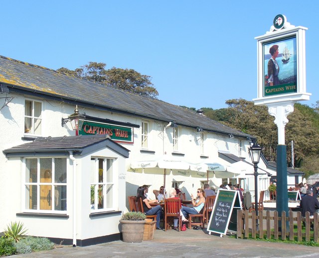
The Captain's Wife

The Captain's Wife is a public house in the former fishing hamlet of Swanbridge in Sully, between Barry and Penarth, Vale of Glamorgan, south Wales. The...

Swanbridge railway station

Swanbridge railway station was located on the now disused railway line between Penarth and Cadoxton, which closed in the 1960s. == History and description... ==

Sully Centurions Cricket Club Ground

Sully Centurions Cricket Club Ground is a cricket ground in Sully, Glamorgan. The first recorded match on the ground was in 2002, when Wales Minor Counties...

Related Videos

Walking Lavernock

Evening drone flight over the WW2 Lavernock gun battery site at Lavernock Point, South Wales, UK.

Sully Island Beach Walk

Easter weekend walk, view of Sully Island #Walk #GoPro #Easter #Beach #Sea #Sun.

Scenic Wales with Mister Seventy Six. Sully Beach and Island.

Scenic Wales with Mister Seventy Six. Sully Beach and Island. #wales #walescoast #cymru #tourism #misterseventysix ...

Have you been to West Point?

Leave your review of West Point below (or comments, questions and feedback).