Geodh' an Dubh Sgeir

Coastal Feature, Headland, Point in Ross-shire

Scotland

Geodh' an Dubh Sgeir

Blackhouse Village at Garenin
Blackhouse Village at Garenin Credit: Colin Park

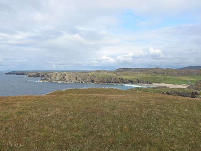
Geodh' an Dubh Sgeir, located in Ross-shire, Scotland, is a prominent coastal feature known for its picturesque headland and point. This stunning geological formation is situated on the rugged coastline of the North Atlantic Ocean.

Geodh' an Dubh Sgeir is characterized by its towering cliffs, which rise majestically from the sea, providing a breathtaking view of the surrounding landscape. These cliffs are composed of weathered sandstone and are adorned with vibrant green vegetation, adding to the area's natural beauty.

The headland and point offer visitors a unique opportunity to witness the raw power of the ocean as waves crash against the rocks below. The constant erosion from the sea has created numerous sea caves and arches, providing a mesmerizing spectacle for nature enthusiasts.

This coastal feature is also a haven for wildlife, attracting a variety of seabirds such as gannets, puffins, and fulmars. The surrounding waters are teeming with marine life, making it a popular spot for fishing and birdwatching.

Access to Geodh' an Dubh Sgeir is relatively easy, with a well-maintained footpath leading visitors to the headland. The site is also a popular destination for hikers and photographers, who are drawn to the dramatic cliffs and stunning coastal views.

Overall, Geodh' an Dubh Sgeir is a captivating coastal feature that showcases the incredible power of nature. Its rugged cliffs, sea caves, and diverse wildlife make it a must-visit destination for anyone seeking to experience the raw beauty of Scotland's coastline.

If you have any feedback on the listing, please let us know in the comments section below.

Geodh' an Dubh Sgeir Images

Images are sourced within 2km of 58.306219/-6.7941838 or Grid Reference NB1945. Thanks to Geograph Open Source API. All images are credited.

Blackhouse Village at Garenin
Ruin by Loch Garenin
Bus shelter near the Tweed Mill
Na Gearrannan The main road through the restored part of the old village of blackhouses. People lived in some of these houses up until 1974.
Na Gearrannan
The main road through the restored part of the old village of blackhouses. People lived in some of these houses up until 1974.
Buildings in Gearrannan Blackhouse Village
Loch Garenin Sea loch below the Black House Village.
Loch Garenin
Sea loch below the Black House Village.
Blackhouse Village at Garenin The village was occupied until 1974. Restored in the later years of the Century. The plaque commemorates the opening of the village as a visitor attraction by Princess Anne. Most of the black houses are let as self-catering holiday accommodation.
Blackhouse Village at Garenin
The village was occupied until 1974. Restored in the later years of the Century. The plaque commemorates the opening of the village as a visitor attraction by Princess Anne. Most of the black houses are let as self-catering holiday accommodation.
Cottage interior, Garenin Blackhouse Village
Garenin Blackhouses Museum Group of reconstructed blackhouses which give an excellent impression of what Hebridean hamlets would have looked like 200 years ago.
Garenin Blackhouses Museum
Group of reconstructed blackhouses which give an excellent impression of what Hebridean hamlets would have looked like 200 years ago.
Garenin Blackhouses Museum A reconstructed blackhouse settlement.
Garenin Blackhouses Museum
A reconstructed blackhouse settlement.
Rubha Mor Neidallt illicit still Illicit still hidden below a large rock outcrop. <span class="nowrap"><a title="https://canmore.org.uk/site/137120/lewis-rubha-mor-neidallt" rel="nofollow ugc noopener" href="https://canmore.org.uk/site/137120/lewis-rubha-mor-neidallt">Link</a><img style="margin-left:2px;" alt="External link" title="External link - shift click to open in new window" src="https://s1.geograph.org.uk/img/external.png" width="10" height="10"/></span>
Rubha Mor Neidallt illicit still
Illicit still hidden below a large rock outcrop. LinkExternal link
Rubha Mor Neidallt illicit still View into the building from the rock outcrop above the building. <span class="nowrap"><a title="https://canmore.org.uk/site/137120/lewis-rubha-mor-neidallt" rel="nofollow ugc noopener" href="https://canmore.org.uk/site/137120/lewis-rubha-mor-neidallt">Link</a><img style="margin-left:2px;" alt="External link" title="External link - shift click to open in new window" src="https://s1.geograph.org.uk/img/external.png" width="10" height="10"/></span>
Rubha Mor Neidallt illicit still
View into the building from the rock outcrop above the building. LinkExternal link
Marker Cairn
Marker Cairn
Aird Mheadhonach cliffs, sheepfold and lazy beds
Historic shelter or shieling
Indented coast west of Dail Mòr The sandy beach is at Dail Mòr. Between this and the camera position there is another deeply incised inlet.
Indented coast west of Dail Mòr
The sandy beach is at Dail Mòr. Between this and the camera position there is another deeply incised inlet.
Rubha an Trilleachain Rocky headland on the western side of Bagh Dhail Mor / Dalmore Bay - with a large northerly swell.
Rubha an Trilleachain
Rocky headland on the western side of Bagh Dhail Mor / Dalmore Bay - with a large northerly swell.
Show me another place!

Geodh' an Dubh Sgeir is located at Grid Ref: NB1945 (Lat: 58.306219, Lng: -6.7941838)

Unitary Authority: Na h-Eileanan an Iar

Police Authority: Highlands and Islands

What 3 Words

///rotations.shrubbery.hurls. Near Carloway, Na h-Eileanan Siar

Related Wikis

Garenin

Garenin (Scottish Gaelic: Na Gearrannan) is a crofting township on the west coast of the Isle of Lewis in the Outer Hebrides of Scotland. Garenin is in...

Borrowston, Lewis

Borrowston (Scottish Gaelic: Borghastan), with a population of about 50, is a crofting township situated on the Isle of Lewis, on the Outer Hebrides of...

Carloway

Carloway (Scottish Gaelic: Càrlabhagh [ˈkʰaːɾɫ̪ə.ɤː]) is a crofting township and a district on the west coast of the Isle of Lewis, in the Outer Hebrides...

Siadar Wave Power Station

The Siadar Wave Power Station (also known as Siadar Wave Energy Project or SWEP) was a proposed 4 MW wave farm 400 metres (1,300 ft) off the shore of Siadar...

Nearby Amenities

Located within 500m of 58.306219,-6.7941838
Tiumpan Head
Note: Geodetic reference point for UK baseline
Ref: 5
Source: The Territorial Sea (Amendment) Order 1998 (No. 2564)
Lat/Long: 58.3074051/-6.7968575
The data included in this document is from www.openstreetmap.org. The data is made available under ODbL.

Have you been to Geodh' an Dubh Sgeir?

Leave your review of Geodh' an Dubh Sgeir below (or comments, questions and feedback).