Broadoak Clough

Valley in Lancashire

England

Broadoak Clough

Junction Inn on Mossley Road
Junction Inn on Mossley Road Credit: Ian S

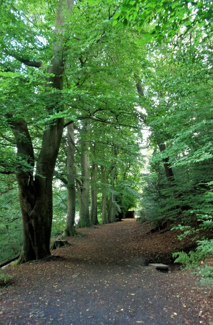
Broadoak Clough is a picturesque valley located in Lancashire, England. Situated in the southern part of the county, the clough is surrounded by rolling hills and dense woodland, offering visitors a tranquil and scenic escape from bustling city life.

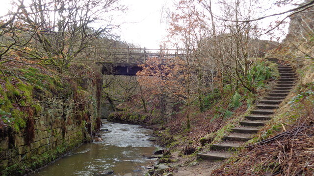
The valley is known for its natural beauty, with a meandering stream that runs through the heart of the clough, creating a soothing soundtrack of babbling water. The stream is flanked by moss-covered rocks and accompanied by an array of wildlife, including ducks, herons, and various species of fish.

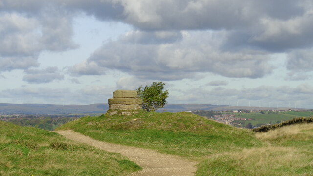
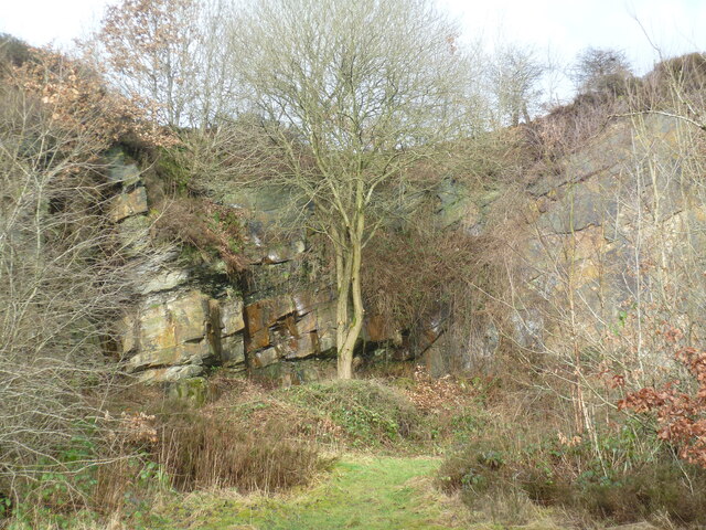
The clough is a popular destination for nature enthusiasts and hikers, with a network of well-maintained walking trails that wind through the valley. These trails provide visitors with the opportunity to explore the diverse flora and fauna of the area while enjoying stunning views of the surrounding countryside.

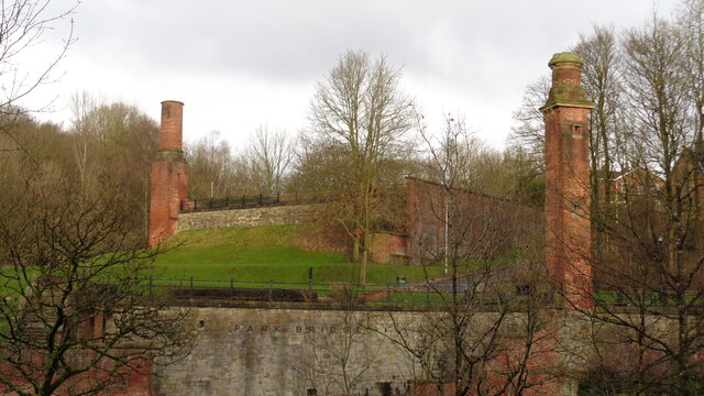
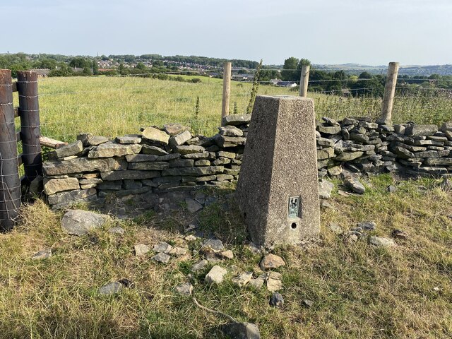
In addition to its natural wonders, Broadoak Clough boasts a rich history. The remains of an ancient stone circle can be found near the entrance of the clough, offering a glimpse into the area's past. The valley also served as a vital resource for local industries, with evidence of former mills and quarries scattered throughout the landscape.

Today, Broadoak Clough continues to attract visitors with its idyllic setting and peaceful atmosphere. Whether it's a leisurely stroll along the stream or an adventurous hike up the hills, this hidden gem in Lancashire provides a serene retreat for all nature lovers.

If you have any feedback on the listing, please let us know in the comments section below.

Broadoak Clough Images

Images are sourced within 2km of 53.507065/-2.0805212 or Grid Reference SD9401. Thanks to Geograph Open Source API. All images are credited.
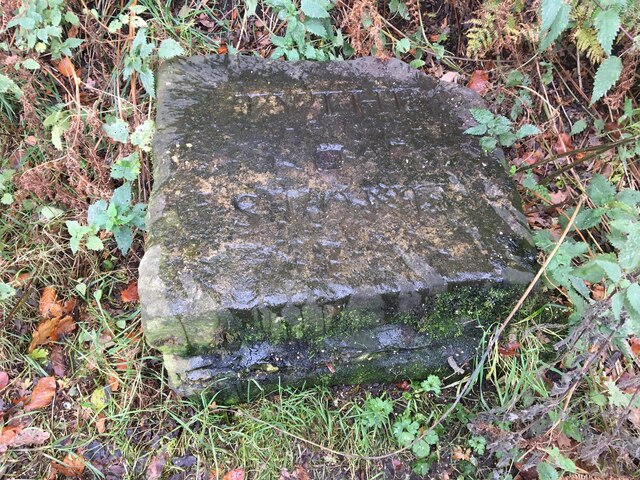
Junction Inn on Mossley Road
Welcome to Ashton under Lyne sign On the A670 Mossley Road.
Welcome to Ashton under Lyne sign
On the A670 Mossley Road.
Inscribed stone on the south side of Twirl Hill Road, Hartshead Inscribed stone on the south side of Twirl Hill Road. In the former Ashton under Lyne parish to 1894 and Hartshead parish from 1894 to 1974. This stone is thought to be the collection place for the northern part of the ancient parish of Ashton-under-Lyne and is situated at a place called Twirl Hill between the hamlets of Alt Hill and Hartshead, just below the local viewpoint of Hartshead Pike. The practice of paying tithes was abandoned in the 1830’s. The “Tythe Stone” inscription is thought to have been made by local man John Coulthard in 1840 to ensure its preservation. See also <span class="nowrap"><a title="http://www.marland.org/places/marlandplaces-twarlhill.htm" rel="nofollow ugc noopener" href="http://www.marland.org/places/marlandplaces-twarlhill.htm">Link</a><img style="margin-left:2px;" alt="External link" title="External link - shift click to open in new window" src="https://s1.geograph.org.uk/img/external.png" width="10" height="10"/></span>

Milestone Society National ID: LA_HARTS01cm
Inscribed stone on the south side of Twirl Hill Road, Hartshead
Inscribed stone on the south side of Twirl Hill Road. In the former Ashton under Lyne parish to 1894 and Hartshead parish from 1894 to 1974. This stone is thought to be the collection place for the northern part of the ancient parish of Ashton-under-Lyne and is situated at a place called Twirl Hill between the hamlets of Alt Hill and Hartshead, just below the local viewpoint of Hartshead Pike. The practice of paying tithes was abandoned in the 1830’s. The “Tythe Stone” inscription is thought to have been made by local man John Coulthard in 1840 to ensure its preservation. See also LinkExternal link Milestone Society National ID: LA_HARTS01cm
Hartshead Pike Rebuilt to commemorate the marriage of Edward, Prince of Wales in 1863
Hartshead Pike
Rebuilt to commemorate the marriage of Edward, Prince of Wales in 1863
Hartshead Pike Well Often marked as a well on maps is this the site of the original tower on the summit of the hill?
Hartshead Pike Well
Often marked as a well on maps is this the site of the original tower on the summit of the hill?
Park Bridge Heritage Centre View from Alt Hill Road of the chimneys of the ironworks roller shop to the left and cotton mill to the right
Park Bridge Heritage Centre
View from Alt Hill Road of the chimneys of the ironworks roller shop to the left and cotton mill to the right
Old Tramway Bridge Over the River Medlock at the Park Bridge industrial heritage site
Old Tramway Bridge
Over the River Medlock at the Park Bridge industrial heritage site
Old Quarry On the Park Bridge industrial heritage site
Old Quarry
On the Park Bridge industrial heritage site
The Rock Trig Point Flush Bracket S2786
OS Cut Mark - Park Bridge, Keverlow Farm <span class="nowrap"><a title="https://www.bench-marks.org.uk/bm60764" rel="nofollow ugc noopener" href="https://www.bench-marks.org.uk/bm60764">Link</a><img style="margin-left:2px;" alt="External link" title="External link - shift click to open in new window" src="https://s1.geograph.org.uk/img/external.png" width="10" height="10"/></span>
OS Cut Mark - Park Bridge, Keverlow Farm
Mill Brow
Mill Brow
St John the Evangelist
OS Cut Mark - Ashton-under-Lyne, #10 Hurst Cross <span class="nowrap"><a title="https://www.bench-marks.org.uk/bm91192" rel="nofollow ugc noopener" href="https://www.bench-marks.org.uk/bm91192">Link</a><img style="margin-left:2px;" alt="External link" title="External link - shift click to open in new window" src="https://s1.geograph.org.uk/img/external.png" width="10" height="10"/></span>
OS Cut Mark - Ashton-under-Lyne, #10 Hurst Cross
Location of OS Cut Mark - Ashton-under-Lyne, #10 Hurst Cross
Nook Lane
Nook Lane
Broad Track from Valley Bridge A former carriage drive from the now demolished Riversvale Hall?
Broad Track from Valley Bridge
A former carriage drive from the now demolished Riversvale Hall?
Railway Bridge Abutments On Alt Hill Lane for the former Oldham and Ashton railway route
Railway Bridge Abutments
On Alt Hill Lane for the former Oldham and Ashton railway route
Old Milestone, A670, Ashton under Lyne On the Eastern side of the road, originally erected by the Stockport and Ashton Turnpike Trust.

Inscription: To / [Ashton] / 2 Miles / To / New / Houses / 3¼

Milestone Society National ID: LA_ALNH02
Old Milestone, A670, Ashton under Lyne
On the Eastern side of the road, originally erected by the Stockport and Ashton Turnpike Trust. Inscription: To / [Ashton] / 2 Miles / To / New / Houses / 3¼ Milestone Society National ID: LA_ALNH02
Show me another place!

Broadoak Clough is located at Grid Ref: SD9401 (Lat: 53.507065, Lng: -2.0805212)

Unitary Authority: Tameside

Police Authority: Greater Manchester

What 3 Words

///face.fills.class. Near Ashton-under-Lyne, Manchester

Nearby Locations

Broadoak Clough Alt Hill

Related Wikis

Great Academy Ashton

Great Academy Ashton (formerly New Charter Academy) is a coeducational secondary school with academy status in Ashton-under-Lyne, Greater Manchester,...

St Damian's Roman Catholic Science College

St Damian's R.C Science College is a coeducational Roman Catholic secondary school located in Ashton-under-Lyne in the English county of Greater Manchester...

Ashton Hurst (ward)

Ashton Hurst is an electoral ward of Tameside, England. It is represented in Westminster by Angela Rayner Labour MP for Ashton-under-Lyne. == Councillors... ==

Ashton United F.C.

Ashton United Football Club is a football club in Ashton-under-Lyne, Greater Manchester, England. They are currently members of the Northern Premier League...

Nearby Amenities

Located within 500m of 53.507065,-2.0805212
Bus Stop
Lees Road/The Red House
Bus: yes
Naptan AtcoCode: 1800EH09311
Naptan Bearing: S
Naptan CommonName: Lees Road/The Red House
Naptan Indicator: Opp Red House Pub
Naptan Landmark: RED HOUSE PUB
Naptan NaptanCode: manawpjt
Naptan Notes: Stop Relocated
Naptan PlusbusZoneRef: MNCRPIC
Naptan ShortCommonName: The Red House
Naptan Street: LEES ROAD
Naptan Verified: no
Network: TfGM
Public Transport: platform
Source: naptan_import
Lat/Long: 53.510334/-2.0775976
Bus Stop
Lees Road/St Damians High School
Bus: yes
Naptan AtcoCode: 1800EH09321
Naptan Bearing: S
Naptan CommonName: Lees Road/St Damians High School
Naptan Indicator: St Damians School
Naptan Landmark: ST DAMIANS SCH
Naptan NaptanCode: manawpjw
Naptan PlusbusZoneRef: MNCRPIC
Naptan ShortCommonName: St Damians HS
Naptan Street: LEES ROAD
Naptan Verified: no
Network: TfGM
Public Transport: platform
Source: naptan_import
Lat/Long: 53.5093902/-2.0776562
Bus Stop
Lees Road/St Damians High School
Bus: yes
Naptan AtcoCode: 1800EH09331
Naptan Bearing: S
Naptan CommonName: Lees Road/St Damians High School
Naptan Indicator: Nr School Field
Naptan Landmark: NR SCHOOL FIELD
Naptan NaptanCode: manawpma
Naptan PlusbusZoneRef: MNCRPIC
Naptan ShortCommonName: St Damians HS
Naptan Street: LEES ROAD
Naptan Verified: no
Network: TfGM
Public Transport: platform
Source: naptan_import
Lat/Long: 53.5092553/-2.0776711
Bus Stop
Lees Road/St Damians High School
Bus: yes
Naptan AtcoCode: 1800EH09341
Naptan Bearing: S
Naptan CommonName: Lees Road/St Damians High School
Naptan Indicator: School Fields
Naptan Landmark: SCHOOL FIELDS
Naptan NaptanCode: manawpmd
Naptan PlusbusZoneRef: MNCRPIC
Naptan ShortCommonName: St Damians HS
Naptan Street: LEES ROAD
Naptan Verified: no
Network: TfGM
Public Transport: platform
Source: naptan_import
Lat/Long: 53.5090306/-2.0776706
Bus Stop
St. Albans Avenue/Lichfield Avenue
Bus: yes
Naptan AtcoCode: 1800EH20611
Naptan Bearing: W
Naptan CommonName: St. Albans Avenue/Lichfield Avenue
Naptan Indicator: O/s House 13/15
Naptan Landmark: HOUSE 13
Naptan NaptanCode: mandadtm
Naptan Notes: LOCATION AMENDMENT
Naptan PlusbusZoneRef: MNCRPIC
Naptan ShortCommonName: Lichfield Avenue
Naptan Street: St Albans Avenue
Naptan Verified: no
Network: TfGM
Public Transport: platform
Source: naptan_import
Lat/Long: 53.509614/-2.0789836
Bus Stop
St. Albans Avenue/Lichfield Avenue
Bus: yes
Naptan AtcoCode: 1800EH20621
Naptan Bearing: E
Naptan CommonName: St. Albans Avenue/Lichfield Avenue
Naptan Indicator: O/s House 10
Naptan Landmark: HOUSE 10
Naptan NaptanCode: mandadtp
Naptan PlusbusZoneRef: MNCRPIC
Naptan ShortCommonName: Lichfield Avenue
Naptan Street: St Albans Avenue
Naptan Verified: no
Network: TfGM
Public Transport: platform
Source: naptan_import
Lat/Long: 53.5097126/-2.0794964
Bus Stop
St. Albans Avenue/Hartshead Post Office
Bus: yes
Naptan AtcoCode: 1800EH20631
Naptan Bearing: W
Naptan CommonName: St. Albans Avenue/Hartshead Post Office
Naptan Indicator: Chip Shop
Naptan Landmark: HOUSE 71
Naptan NaptanCode: mandadtw
Naptan PlusbusZoneRef: MNCRPIC
Naptan ShortCommonName: Hartshead PO
Naptan Street: St Albans Avenue
Naptan Verified: no
Network: TfGM
Public Transport: platform
Source: naptan_import
Lat/Long: 53.5081558/-2.0821172
Bus Stop
St. Albans Avenue/Hartshead Post Office
Bus: yes
Naptan AtcoCode: 1800EH20641
Naptan Bearing: N
Naptan CommonName: St. Albans Avenue/Hartshead Post Office
Naptan Indicator: Junior School
Naptan Landmark: JUNIOR SCHOOL
Naptan NaptanCode: mandadwa
Naptan PlusbusZoneRef: MNCRPIC
Naptan ShortCommonName: Hartshead PO
Naptan Street: St Albans Avenue
Naptan Verified: no
Network: TfGM
Public Transport: platform
Source: naptan_import
Lat/Long: 53.5088031/-2.0819073
Bus Stop
St. Albans Avenue/Alton Close
Bus: yes
Naptan AtcoCode: 1800EH20651
Naptan Bearing: E
Naptan CommonName: St. Albans Avenue/Alton Close
Naptan Indicator: House 111
Naptan Landmark: HOUSE 1
Naptan NaptanCode: mandadwd
Naptan Notes: INDICATOR AMENDED
Naptan PlusbusZoneRef: MNCRPIC
Naptan ShortCommonName: Alton Close
Naptan Street: St Albans Avenue
Naptan Verified: no
Network: TfGM
Public Transport: platform
Source: naptan_import
Lat/Long: 53.5085935/-2.0860234
Bus Stop
St. Albans Avenue/Exmoor Close
Bus: yes
Naptan AtcoCode: 1800EH20661
Naptan Bearing: W
Naptan CommonName: St. Albans Avenue/Exmoor Close
Naptan Indicator: O/s House 121
Naptan Landmark: HOUSE 121
Naptan NaptanCode: mandadwg
Naptan PlusbusZoneRef: MNCRPIC
Naptan ShortCommonName: Exmoor Close
Naptan Street: St Albans Avenue
Naptan Verified: no
Network: TfGM
Public Transport: platform
Source: naptan_import
Lat/Long: 53.5082689/-2.0873647
Bus Stop
Broadoak Road/Oakfold Avenue
Bus: yes
Naptan AtcoCode: 1800EH20781
Naptan Bearing: W
Naptan CommonName: Broadoak Road/Oakfold Avenue
Naptan Indicator: Layby
Naptan Landmark: HOUSE 246
Naptan NaptanCode: mandagaw
Naptan PlusbusZoneRef: MNCRPIC
Naptan ShortCommonName: Oakfold Avenue
Naptan Street: BROADOAK ROAD
Naptan Verified: no
Network: TfGM
Public Transport: platform
Source: naptan_import
Lat/Long: 53.5038983/-2.0821121
Bus Stop
Broadoak Road/Oakfold Avenue
Bus: yes
Naptan AtcoCode: 1800EH20791
Naptan Bearing: E
Naptan CommonName: Broadoak Road/Oakfold Avenue
Naptan Indicator: Foodstore
Naptan Landmark: School
Naptan NaptanCode: mandagda
Naptan PlusbusZoneRef: MNCRPIC
Naptan ShortCommonName: Oakfold Avenue
Naptan Street: Oak Grove
Naptan Verified: no
Network: TfGM
Public Transport: platform
Source: naptan_import
Lat/Long: 53.504044/-2.0801157
Bus Stop
Lees Road/The Red House
Bus: yes
Naptan AtcoCode: 1800EH08971
Naptan Bearing: N
Naptan CommonName: Lees Road/The Red House
Naptan Indicator: Red House Pub
Naptan Landmark: RED HOUSE PUB
Naptan NaptanCode: manawpaj
Naptan Notes: INDICATOR AMENDED
Naptan PlusbusZoneRef: MNCRPIC
Naptan ShortCommonName: The Red House
Naptan Street: LEES ROAD
Naptan Verified: no
Network: TfGM
Public Transport: platform
Source: naptan_import
Lat/Long: 53.510244/-2.0777784
Bus Stop
Lees Road/Hartshead High School
Bus: yes
Naptan AtcoCode: 1800EH21071
Naptan Bearing: S
Naptan CommonName: Lees Road/Hartshead High School
Naptan Indicator: Hartshead High
Naptan Landmark: NEW CHARTER
Naptan NaptanCode: mandagta
Naptan PlusbusZoneRef: MNCRPIC
Naptan ShortCommonName: Hartshead HS
Naptan Street: LEES ROAD
Naptan Verified: no
Network: TfGM
Public Transport: platform
Source: naptan_import
Lat/Long: 53.5063609/-2.0777864
Bus Stop
Lees Road/St. Christopher's
Bus: yes
Naptan AtcoCode: 1800EH21081
Naptan Bearing: N
Naptan CommonName: Lees Road/St. Christopher's
Naptan Indicator: Opp Church
Naptan Landmark: HOUSE 63
Naptan NaptanCode: mandagtd
Naptan PlusbusZoneRef: MNCRPIC
Naptan ShortCommonName: St. Christopher's
Naptan Street: LEES ROAD
Naptan Verified: no
Network: TfGM
Public Transport: platform
Source: naptan_import
Lat/Long: 53.5038799/-2.0780834
Bus Stop
Lees Road/St Christopher's
Bus: yes
Naptan AtcoCode: 1800EH21091
Naptan Bearing: S
Naptan CommonName: Lees Road/St Christopher's
Naptan Indicator: Church
Naptan Landmark: CHURCH
Naptan NaptanCode: mandagtg
Naptan PlusbusZoneRef: MNCRPIC
Naptan ShortCommonName: St Christopher's
Naptan Street: LEES ROAD
Naptan Verified: no
Network: TfGM
Public Transport: platform
Source: naptan_import
Lat/Long: 53.5036642/-2.0779322
College
New Charter College, Greenhurst Campus
Lat/Long: 53.5067915/-2.0762781
College
St Damian's R.C. Science College
Lat/Long: 53.5094809/-2.0765731
Mini Roundabout
Direction: clockwise
Lat/Long: 53.5039594/-2.0753889
Power: tower
Lat/Long: 53.5069231/-2.0787416
Power: tower
Lat/Long: 53.5061103/-2.0812117
Power: tower
Lat/Long: 53.5078363/-2.0758687
Generator Method: photovoltaic
Generator Output Electricity: yes
Generator Source: solar
Generator Type: solar_photovoltaic_panel
Location: roof
Power: generator
Lat/Long: 53.5069906/-2.0868221
Generator Method: photovoltaic
Generator Output Electricity: yes
Generator Source: solar
Generator Type: solar_photovoltaic_panel
Location: roof
Power: generator
Lat/Long: 53.5085826/-2.0846656
Generator Method: photovoltaic
Generator Output Electricity: yes
Generator Source: solar
Generator Type: solar_photovoltaic_panel
Location: roof
Power: generator
Lat/Long: 53.5085571/-2.0848319
Generator Method: photovoltaic
Generator Output Electricity: yes
Generator Source: solar
Generator Type: solar_photovoltaic_panel
Location: roof
Power: generator
Lat/Long: 53.508506/-2.0850519
Generator Method: photovoltaic
Generator Output Electricity: yes
Generator Source: solar
Generator Type: solar_photovoltaic_panel
Location: roof
Power: generator
Lat/Long: 53.5081742/-2.0848856
Generator Method: photovoltaic
Generator Output Electricity: yes
Generator Source: solar
Generator Type: solar_photovoltaic_panel
Location: roof
Power: generator
Lat/Long: 53.5075394/-2.0832065
Generator Method: photovoltaic
Generator Output Electricity: yes
Generator Source: solar
Generator Type: solar_photovoltaic_panel
Location: roof
Power: generator
Lat/Long: 53.508439/-2.0812753
Generator Method: photovoltaic
Generator Output Electricity: yes
Generator Source: solar
Generator Type: solar_photovoltaic_panel
Location: roof
Power: generator
Lat/Long: 53.5087166/-2.0809266
Generator Method: photovoltaic
Generator Output Electricity: yes
Generator Source: solar
Generator Type: solar_photovoltaic_panel
Location: roof
Power: generator
Lat/Long: 53.508439/-2.0806638
Generator Method: photovoltaic
Generator Output Electricity: yes
Generator Source: solar
Generator Type: solar_photovoltaic_panel
Location: roof
Power: generator
Lat/Long: 53.5095173/-2.0805404
Generator Method: photovoltaic
Generator Output Electricity: yes
Generator Source: solar
Generator Type: solar_photovoltaic_panel
Location: roof
Power: generator
Lat/Long: 53.5097885/-2.0796714
Generator Method: photovoltaic
Generator Output Electricity: yes
Generator Source: solar
Generator Type: solar_photovoltaic_panel
Location: roof
Power: generator
Lat/Long: 53.5097885/-2.0793334
Generator Method: photovoltaic
Generator Output Electricity: yes
Generator Source: solar
Generator Type: solar_photovoltaic_panel
Location: roof
Power: generator
Lat/Long: 53.5097789/-2.0791564
Generator Method: photovoltaic
Generator Output Electricity: yes
Generator Source: solar
Generator Type: solar_photovoltaic_panel
Location: roof
Power: generator
Lat/Long: 53.5097821/-2.0815167
Generator Method: photovoltaic
Generator Output Electricity: yes
Generator Source: solar
Generator Type: solar_photovoltaic_panel
Location: roof
Power: generator
Lat/Long: 53.5092749/-2.0795372
Generator Method: photovoltaic
Generator Output Electricity: yes
Generator Source: solar
Generator Type: solar_photovoltaic_panel
Location: roof
Power: generator
Lat/Long: 53.5094727/-2.0793978
Generator Method: photovoltaic
Generator Output Electricity: yes
Generator Source: solar
Generator Type: solar_photovoltaic_panel
Location: roof
Power: generator
Lat/Long: 53.5094886/-2.0790866
Generator Method: photovoltaic
Generator Output Electricity: yes
Generator Source: solar
Generator Type: solar_photovoltaic_panel
Location: roof
Power: generator
Lat/Long: 53.509227/-2.0786628
Generator Method: photovoltaic
Generator Output Electricity: yes
Generator Source: solar
Generator Type: solar_photovoltaic_panel
Location: roof
Power: generator
Lat/Long: 53.5092174/-2.0785287
Generator Method: photovoltaic
Generator Output Electricity: yes
Generator Source: solar
Generator Type: solar_photovoltaic_panel
Location: roof
Power: generator
Lat/Long: 53.5092079/-2.0782712
Generator Method: photovoltaic
Generator Output Electricity: yes
Generator Source: solar
Generator Type: solar_photovoltaic_panel
Location: roof
Power: generator
Lat/Long: 53.5109301/-2.0810353
Generator Method: photovoltaic
Generator Output Electricity: yes
Generator Source: solar
Generator Type: solar_photovoltaic_panel
Location: roof
Power: generator
Lat/Long: 53.5104213/-2.0803915
Generator Method: photovoltaic
Generator Output Electricity: yes
Generator Source: solar
Generator Type: solar_photovoltaic_panel
Location: roof
Power: generator
Lat/Long: 53.5082727/-2.0815824
Generator Method: photovoltaic
Generator Output Electricity: yes
Generator Source: solar
Generator Type: solar_photovoltaic_panel
Location: roof
Power: generator
Lat/Long: 53.5112459/-2.0811479
Generator Method: photovoltaic
Generator Output Electricity: yes
Generator Source: solar
Generator Type: solar_photovoltaic_panel
Location: roof
Power: generator
Lat/Long: 53.51108/-2.0818346
Generator Method: photovoltaic
Generator Output Electricity: yes
Generator Source: solar
Generator Type: solar_photovoltaic_panel
Location: roof
Power: generator
Lat/Long: 53.5086141/-2.0863595
Generator Method: photovoltaic
Generator Output Electricity: yes
Generator Source: solar
Generator Type: solar_photovoltaic_panel
Location: roof
Power: generator
Lat/Long: 53.5045271/-2.0772401
Generator Method: photovoltaic
Generator Output Electricity: yes
Generator Source: solar
Generator Type: solar_photovoltaic_panel
Location: roof
Power: generator
Lat/Long: 53.5055859/-2.0770042
Generator Method: photovoltaic
Generator Output Electricity: yes
Generator Source: solar
Generator Type: solar_photovoltaic_panel
Location: roof
Power: generator
Lat/Long: 53.5055827/-2.0771061
Crossing
Crossing: marked
Crossing Island: no
Tactile Paving: no
Lat/Long: 53.5041669/-2.0814559
The data included in this document is from www.openstreetmap.org. The data is made available under ODbL.

Have you been to Broadoak Clough?

Leave your review of Broadoak Clough below (or comments, questions and feedback).