Meall-Dubh

Hill, Mountain in Inverness-shire

Scotland

Meall-Dubh

Navigation light, Gasaigh
Navigation light, Gasaigh Credit: Alpin Stewart

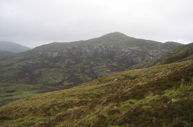
Meall-Dubh is a prominent hill located in the Inverness-shire region of Scotland. The hill stands at an elevation of approximately 657 meters (2,156 feet) above sea level, making it a popular destination for hikers and outdoor enthusiasts seeking stunning panoramic views of the surrounding landscape.

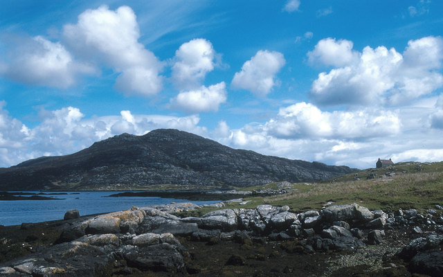
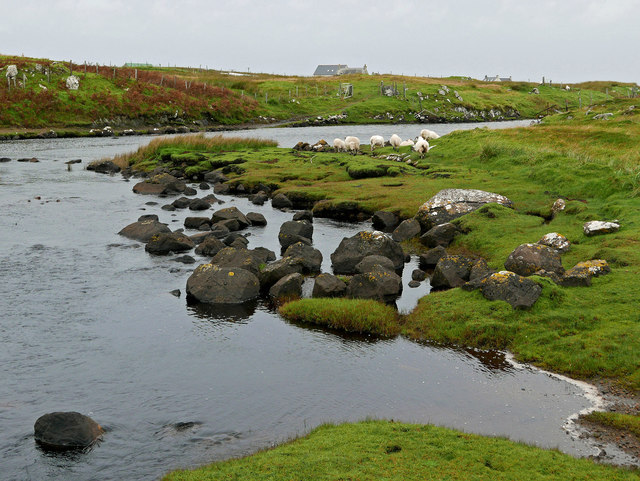
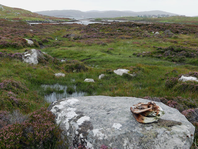
Meall-Dubh is known for its rugged terrain, which includes rocky outcrops, heather-covered slopes, and grassy meadows. The hill is situated in close proximity to the village of Inverarnie, providing easy access for visitors looking to explore the area.

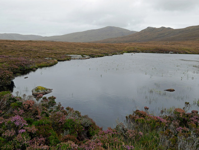
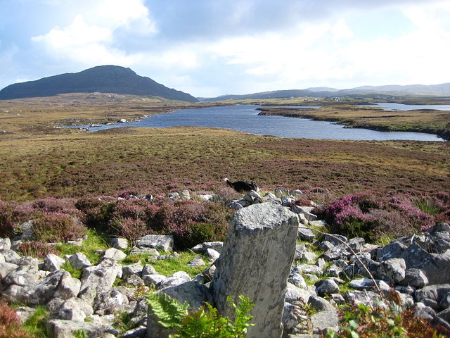
The summit of Meall-Dubh offers breathtaking views of the Scottish Highlands, including nearby Loch Ness and the Great Glen. On a clear day, hikers can see as far as the Ben Nevis mountain range to the west and the Cairngorms to the east.

Due to its relatively moderate elevation and accessible location, Meall-Dubh is a popular destination for hikers of all skill levels. The hill is also home to a variety of wildlife, including red deer, birds of prey, and rare plant species.

Overall, Meall-Dubh offers a rewarding outdoor experience for those looking to immerse themselves in the natural beauty of the Scottish countryside.

If you have any feedback on the listing, please let us know in the comments section below.

Meall-Dubh Images

Images are sourced within 2km of 57.153073/-7.3141784 or Grid Reference NF7819. Thanks to Geograph Open Source API. All images are credited.
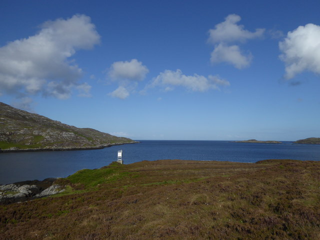
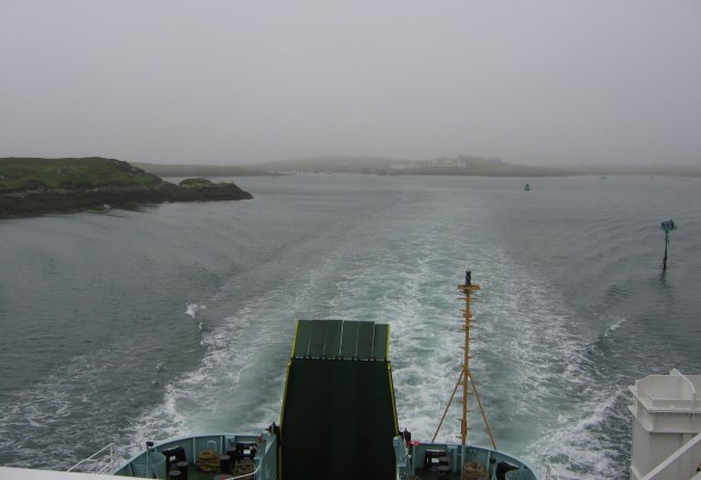
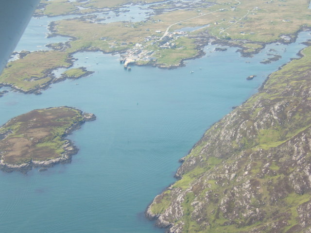
Navigation light, Gasaigh
Beinn Ruigh Choinnich from the ferry
Coastline Below Beinn Ruigh Choinnich Rocky shore on the north of the sea loch, Loch Baghasdail / Loch Boisdale. Risen sea levels have created a "drowned landscape".
Coastline Below Beinn Ruigh Choinnich
Rocky shore on the north of the sea loch, Loch Baghasdail / Loch Boisdale. Risen sea levels have created a "drowned landscape".
Beinn Ruigh Choinnich from South Lochboisdale View over Eileanan Iasgaich and Loch Boisdale with Beinn Ruigh on the right, Stulabhal in the centre and Airneabhal to the left
Beinn Ruigh Choinnich from South Lochboisdale
View over Eileanan Iasgaich and Loch Boisdale with Beinn Ruigh on the right, Stulabhal in the centre and Airneabhal to the left
Steaming out of Loch Baghasdail Not sure if 'steaming' is quite the right expression to describe the movement of a diesel powered car ferry. Taken from the deck of MV 'Lord of the Isles' having just passed the small island of Gasaigh [centre left]. Lochboisdale port can be seen in the distance.
Steaming out of Loch Baghasdail
Not sure if 'steaming' is quite the right expression to describe the movement of a diesel powered car ferry. Taken from the deck of MV 'Lord of the Isles' having just passed the small island of Gasaigh [centre left]. Lochboisdale port can be seen in the distance.
Triuirebheinn from the slopes of Beinn Ruigh Choinnich. Rough going on the hills north of Lochboisdale/Loch Baghasdail.
Triuirebheinn from the slopes of Beinn Ruigh Choinnich.
Rough going on the hills north of Lochboisdale/Loch Baghasdail.
Passing Gasaigh Out in Loch Baghasdail on the ferry to Oban, passing the small island of Gasaigh.
Passing Gasaigh
Out in Loch Baghasdail on the ferry to Oban, passing the small island of Gasaigh.
Beinn Ruigh Choinnich
Loch Baghasdail The island to the upper left is Gasaigh.  To the lower right is a fish farm, off An Camas.
Loch Baghasdail
The island to the upper left is Gasaigh. To the lower right is a fish farm, off An Camas.
Loch Baghasdail Gasaigh is on the left - the white-washed buildings of Lochboisdale, with the ferry-point, are in the centre-distance.
Loch Baghasdail
Gasaigh is on the left - the white-washed buildings of Lochboisdale, with the ferry-point, are in the centre-distance.
Loch nan Smalag
Loch nan Smalag
Permit fishing only By the footbridge at Oratobht.  The distant hills are Triuirebheinn (left) and Beinn Ruigh Choinnich (right).  There is a ford here also.
Permit fishing only
By the footbridge at Oratobht. The distant hills are Triuirebheinn (left) and Beinn Ruigh Choinnich (right). There is a ford here also.
Footbridge at Clachan Mora There is a ford here too for vehicles. The access for vehicles from Lochboisdale is the brown terrace to the west of the far side of the bridge.
Footbridge at Clachan Mora
There is a ford here too for vehicles. The access for vehicles from Lochboisdale is the brown terrace to the west of the far side of the bridge.
Downstream from Loch a Bharp Looking upstream from by the footbridge at Oratobht.
Downstream from Loch a Bharp
Looking upstream from by the footbridge at Oratobht.
Moorland by Lochboisdale Beside the path to Loch nan Smalag, a cattle skull adds an unexpected element to the treeless heather-dominated landscape.
Moorland by Lochboisdale
Beside the path to Loch nan Smalag, a cattle skull adds an unexpected element to the treeless heather-dominated landscape.
Loch nan Smalag - water for Lochboisdale Essentially a loch in two sections with a minor stream to cross between them.  This is the much smaller part.  The loch is dammed and appears to be the water supply for Lochboisdale.  The distant hill is Stulabhal.
Loch nan Smalag - water for Lochboisdale
Essentially a loch in two sections with a minor stream to cross between them. This is the much smaller part. The loch is dammed and appears to be the water supply for Lochboisdale. The distant hill is Stulabhal.
Loch Bharp Looking down on L. Bharp from the large chambered cairn that overlooks it.
Loch Bharp
Looking down on L. Bharp from the large chambered cairn that overlooks it.
Ruin by Loch a' Bharp
Show me another place!

Meall-Dubh is located at Grid Ref: NF7819 (Lat: 57.153073, Lng: -7.3141784)

Unitary Authority: Na h-Eileanan an Iar

Police Authority: Highlands and Islands

What 3 Words

///biggest.tinsel.sidelined. Near Lochboisdale, Na h-Eileanan Siar

Related Wikis

Lochboisdale

Lochboisdale (Scottish Gaelic: Loch Baghasdail [ɫ̪ɔx ˈbɤːs̪t̪ɪl]) is the main village and port on the island of South Uist, Outer Hebrides, Scotland. Lochboisdale...
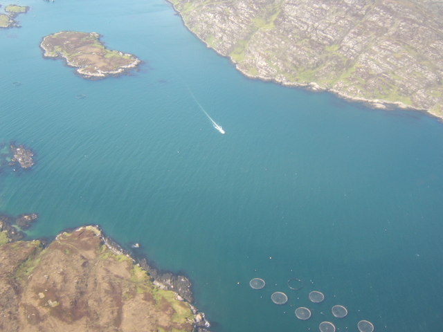
Eileanan Iasgaich

Na h-Eileanan Iasgaich comprise a small uninhabited archipelago in Loch Boisdale, in the south east of the island of South Uist, in the Outer Hebrides...

Auratote

Auratote (Scottish Gaelic: Oratobht) is a location on South Uist in the Outer Hebrides, Scotland. Auratote is within the parish of South Uist. == References... ==

Papar

The Papar (Icelandic pronunciation: [ˈpʰaːpar̥]; from Latin papa, via Old Irish, meaning "father" or "pope") were, according to early Icelandic sagas,...

Nearby Amenities

Located within 500m of 57.153073,-7.3141784
Loch Baghasdail
Is In: Uibhist a Deas, Na h-Eileanan Siar, Scotland, UK
Name En: Lochboisdale
Name Gd: Loch Baghasdail
Place: village
Population: 300
Wikidata: Q1016308
Wikipedia: en:Lochboisdale
Lat/Long: 57.1529183/-7.3073209
Barrier: cattle_grid
Lat/Long: 57.1554568/-7.314579
Telephone
Booth: KX100
Covered: booth
Source: survey
Lat/Long: 57.1531751/-7.3077975
Source: survey
Tourism: information
Lat/Long: 57.1531134/-7.3078423
Toilets
Source: survey
Lat/Long: 57.1530457/-7.3079616
Turning Circle
Lat/Long: 57.1569421/-7.3111455
Fuel
Hillside Filling Station
Brand: Gulf
Fuel Diesel: yes
Fuel Octane 95: yes
Mapillary: 3256792137931688
Self Service: yes
Survey Date: 2022-06-18
Lat/Long: 57.155009/-7.3123519
Car Wash
Lat/Long: 57.1549045/-7.3119082
Post Office
Lochboisdale Post Office
Addr Postcode: HS8 5TH
Opening Hours: Mo,Tu,Th,Fr 09:00-13:00,14:00-17:30; We 09:00-13:00; Sa 10:00-14:00
Ref Pol Id: 3892
Lat/Long: 57.1549683/-7.3100113
Post Box
Collection Times: Mo-Fr 12:15; Sa 07:30
Operator: Royal Mail
Post Box Mounting: wall
Post Box Type: lamp
Ref: HS8 71
Royal Cypher: scottish_crown
Lat/Long: 57.1549613/-7.3101213
Guest House: bed_and_breakfast
Tourism: guest_house
Lat/Long: 57.153863/-7.3098071
Turning Circle
Lat/Long: 57.1524194/-7.3110815
Cafe
Lochboisdale Café
Addr Postcode: HS8 5TJ
Facebook: https://www.facebook.com/UistPO/
Fhrs Id: 806730
Internet Access: wlan
Twitter: https://twitter.com/UistPO
Lat/Long: 57.155041/-7.3101105
Bank
RBS
Addr City: Loch Baghasdail
Atm: yes
Brand: RBS
Brand Wikidata: Q160126
Brand Wikipedia: en:Royal Bank of Scotland
Name En: Royal Bank of Scotland
Name Gd: Banca Rìoghail na h-Alba
Official Name: Royal Bank of Scotland
Operator: Royal Bank of Scotland
Lat/Long: 57.1533415/-7.3084279
Generator Method: photovoltaic
Generator Output Electricity: yes
Generator Source: solar
Generator Type: solar_photovoltaic_panel
Power: generator
Lat/Long: 57.1522341/-7.3102126
Barrier: cattle_grid
Lat/Long: 57.1554694/-7.3170481
Access: customers
Entrance: yes
Lat/Long: 57.1533366/-7.3082873
Entrance: yes
Lat/Long: 57.155113/-7.3121502
Access: customers
Entrance: yes
Lat/Long: 57.1549582/-7.3100692
Entrance: yes
Lat/Long: 57.1549743/-7.3101449
Access: private
Entrance: yes
Lat/Long: 57.1547231/-7.3096184
Access: private
Entrance: yes
Lat/Long: 57.1547249/-7.3097672
Access: private
Entrance: yes
Lat/Long: 57.1546577/-7.3093251
Access: private
Entrance: yes
Lat/Long: 57.15461/-7.309218
Access: private
Entrance: yes
Lat/Long: 57.1545091/-7.3089971
Access: private
Entrance: yes
Lat/Long: 57.1544424/-7.3088536
Access: private
Entrance: yes
Lat/Long: 57.1542294/-7.308308
Access: private
Entrance: yes
Lat/Long: 57.1541933/-7.308226
Access: private
Entrance: yes
Lat/Long: 57.1540911/-7.3079938
Access: private
Entrance: yes
Lat/Long: 57.1541334/-7.30809
Parking
Capacity: 6
Parking: surface
Lat/Long: 57.1541529/-7.3078313
Turning Circle
Lat/Long: 57.1536958/-7.3079056
Power: pole
Lat/Long: 57.1572892/-7.3142898
Power: pole
Lat/Long: 57.1570375/-7.3137453
Power: pole
Lat/Long: 57.1566913/-7.3130318
Power: pole
Lat/Long: 57.1564484/-7.3125061
Power: pole
Lat/Long: 57.1561764/-7.3119
Power: pole
Lat/Long: 57.1558927/-7.3112911
Power: pole
Lat/Long: 57.1553443/-7.3101109
Power: pole
Lat/Long: 57.1549471/-7.3092875
Power: pole
Lat/Long: 57.1548991/-7.3086116
Power: pole
Lat/Long: 57.1548395/-7.307595
Power: pole
Lat/Long: 57.1543889/-7.3066857
Power: pole
Lat/Long: 57.1555108/-7.3156322
Power: pole
Lat/Long: 57.1558796/-7.315313
Power: pole
Lat/Long: 57.1564134/-7.3147766
Power: pole
Lat/Long: 57.1569124/-7.3145232
Power: pole
Lat/Long: 57.1548707/-7.3164396
Macaulay Askernish ltd
Office: yes
Lat/Long: 57.1544906/-7.3090272
Drinking Water
Lat/Long: 57.1530159/-7.3079534
Meall-dubh
Place: locality
Lat/Long: 57.1530688/-7.3139515
Durinish
Natural: cape
Lat/Long: 57.1521493/-7.320539
Construction: memorial
Note: Marloch Memorial under construction
Lat/Long: 57.1525513/-7.3066641
Barrier: bollard
Lat/Long: 57.1532876/-7.3081322
Barrier: bollard
Lat/Long: 57.1531067/-7.3080109
The data included in this document is from www.openstreetmap.org. The data is made available under ODbL.

Have you been to Meall-Dubh?

Leave your review of Meall-Dubh below (or comments, questions and feedback).