Busby Moor

Downs, Moorland in Yorkshire Hambleton

England

Busby Moor

Carlton Bank view Looking towards Whorl Hill from Carlton Bank.
Carlton Bank view Credit: T Eyre

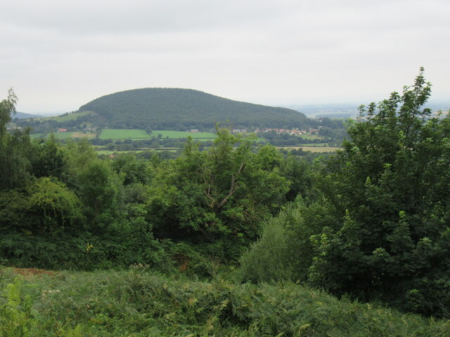
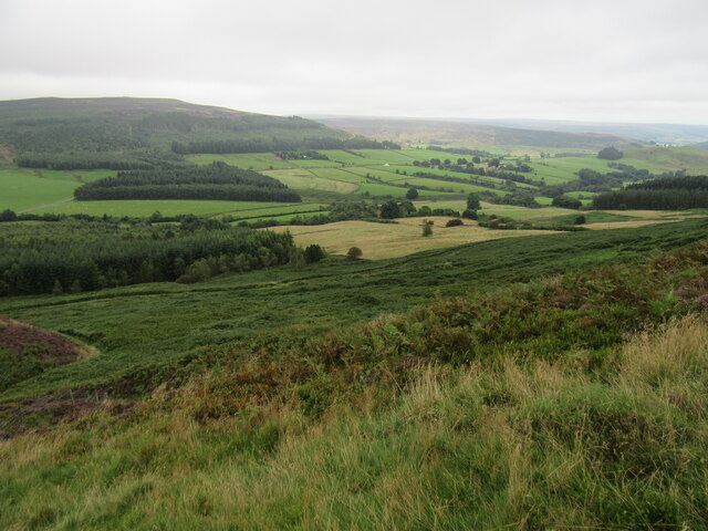
Busby Moor, located in Yorkshire, England, is a picturesque area encompassing both downs and moorland. Stretching across an approximate area of 10 square miles, it offers breathtaking views and diverse landscapes that attract visitors from far and wide.

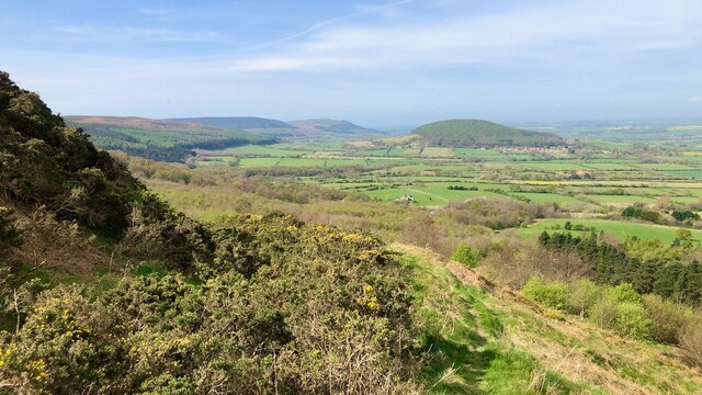
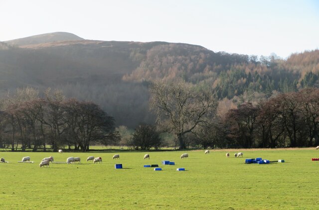
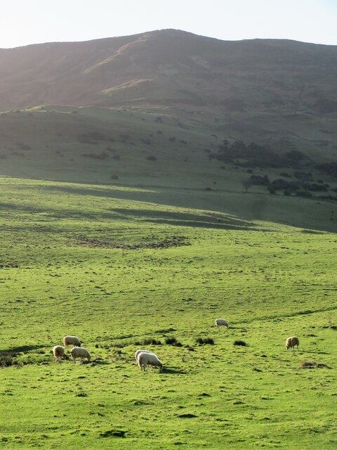
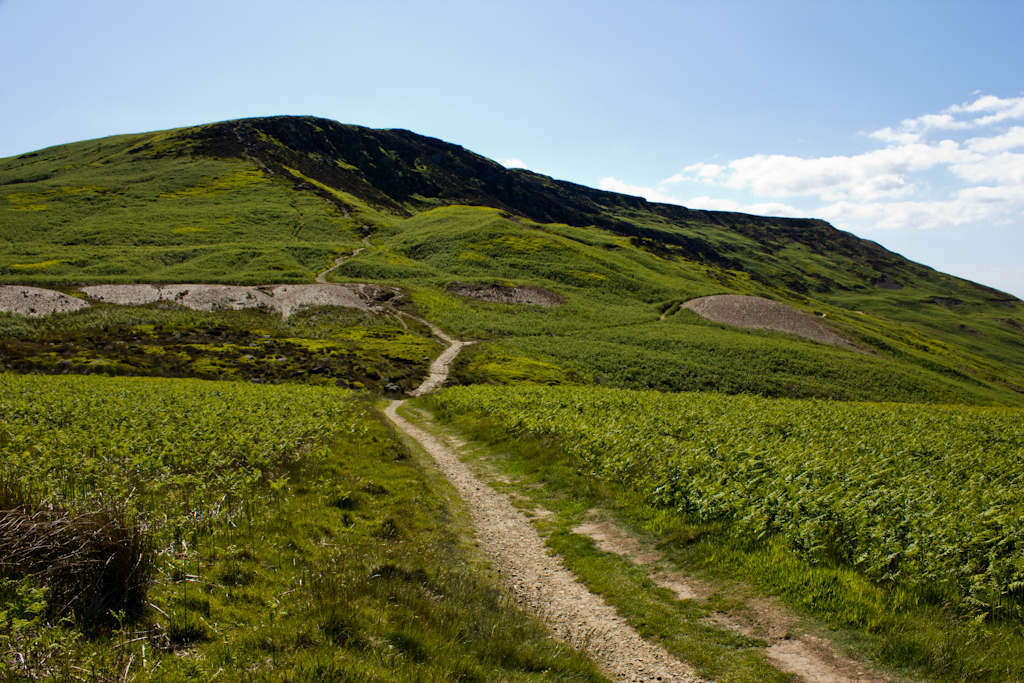
The downs of Busby Moor are characterized by their gently rolling hills, covered in lush green grass and scattered with vibrant wildflowers during the summer months. This creates an idyllic setting for leisurely walks or picnics, allowing visitors to immerse themselves in the tranquility of the surrounding nature.

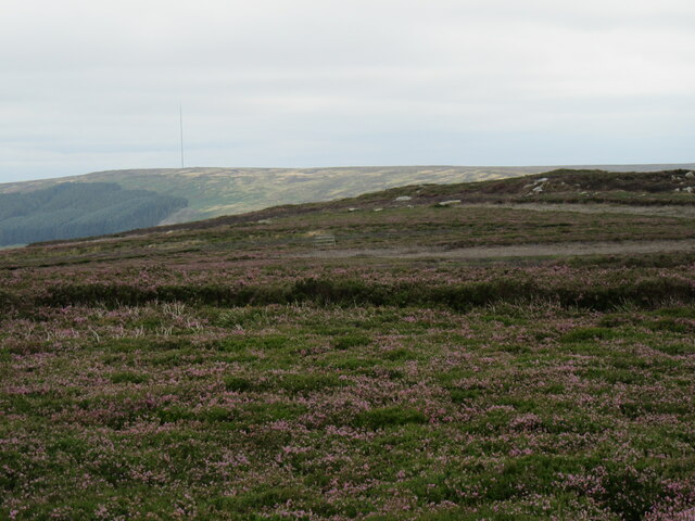
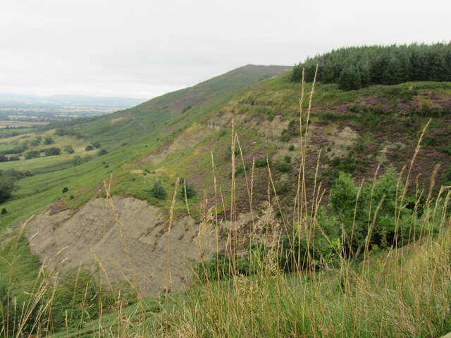
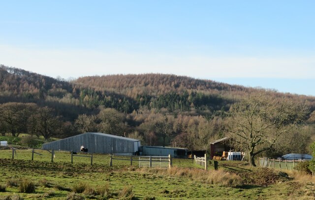
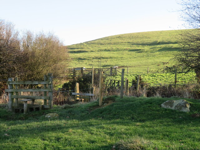
In contrast, the moorland of Busby Moor provides a more rugged and wild terrain. Here, visitors can find vast expanses of heather-covered moors, interspersed with rocky outcrops and small streams. This untamed landscape is home to a variety of flora and fauna, including rare bird species and unique plant life.

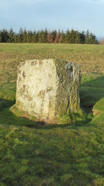
The area is also renowned for its historical significance. Busby Moor is home to ancient burial mounds and stone circles, evidence of human habitation dating back thousands of years. These archaeological sites provide insight into the lives and cultures of the early inhabitants of the region.

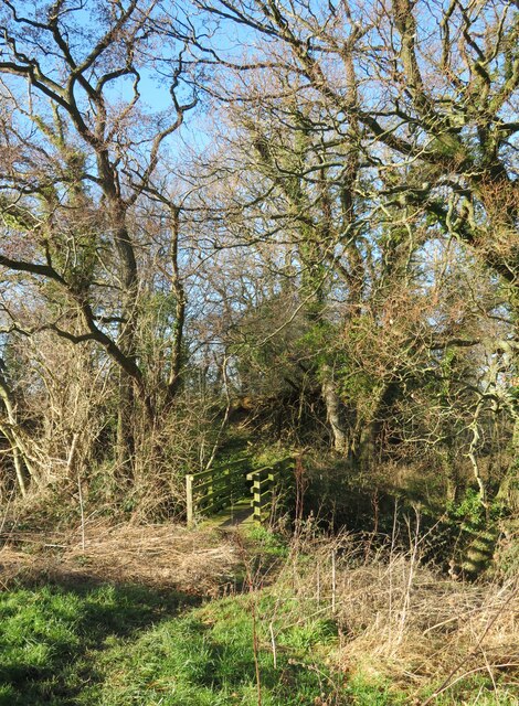
Furthermore, Busby Moor offers numerous recreational activities for visitors to enjoy. Hiking and walking trails crisscross the area, allowing for exploration and discovery of its natural beauty. Birdwatchers and nature enthusiasts will find ample opportunities to observe and appreciate the diverse wildlife that calls the moorland home.

In conclusion, Busby Moor, with its downs and moorland, is a captivating destination that showcases the beauty of Yorkshire's countryside. Its stunning landscapes, rich history, and recreational offerings make it a must-visit location for nature lovers and history enthusiasts alike.

If you have any feedback on the listing, please let us know in the comments section below.

Busby Moor Images

Images are sourced within 2km of 54.422737/-1.1878663 or Grid Reference NZ5203. Thanks to Geograph Open Source API. All images are credited.

Carlton Bank view Looking towards Whorl Hill from Carlton Bank.
Carlton Bank view
Looking towards Whorl Hill from Carlton Bank.
Bilsdale West Moor Near the demolished gliding club.
Bilsdale West Moor
Near the demolished gliding club.
Carlton Moor view Looking NW from the trig point on Carlton Moor.
Carlton Moor view
Looking NW from the trig point on Carlton Moor.
The top of Raisdale Looking SE into Raisdale from the Cleveland Way.
The top of Raisdale
Looking SE into Raisdale from the Cleveland Way.
Green Bank Green Bank is a steep slope to the north of Lord Stone's.
Green Bank
Green Bank is a steep slope to the north of Lord Stone's.
Green Bank I’ve entitled this ‘Green Bank’.

That’s the name of the slight rise that can be made out on the col between Cringle Moor and Carlton Bank. Just to the left of Roseberry in the distant. The col is now lorded over by the misnamed Lord Stones Cafe.

The foreground is heavily dominated by the skeletal remains of last summer’s bracken. The holloways probably result from the sledding down of peat/turf and heather from the moor top.

I’ve always thought bracken was the bane of the farmer’s life, the bane of the conservationist’s. Yet I was reading an article the other day which actually sees the bracken problem as an “opportunity”.

The soil on which bracken grows is apparently deep and rich, and so very suitable for trees, which we need more of. This richness of the soil is indicated in an old farming saying: ‘Where there’s bracken there’s gold; where there’s gorse there’s silver; where there’s heather there’s poverty’.

So, the article advocates that bracken strands should be planted with trees, which will, once mature, shade out the bracken. Obviously the trees initially need to be of sufficient height for themselves not to be shaded out by the bracken.

As bracken is generally avoided by grazing animals, there won’t be any need for the ubiquitous army of plastic tubes.

I try to imagine forests of trees, broadleaf that is, not coniferous, wherever there is bracken. The steep escarpment slopes would be most affected.  In the long term this would certainly change the look of the moors. In the short term it is likely to be met with a negative public reaction.

For sources and references see <span class="nowrap"><a title="http://www.fhithich.uk/?p=27337" rel="nofollow ugc noopener" href="http://www.fhithich.uk/?p=27337">Link</a><img style="margin-left:2px;" alt="External link" title="External link - shift click to open in new window" src="https://s1.geograph.org.uk/img/external.png" width="10" height="10"/></span>
Green Bank
I’ve entitled this ‘Green Bank’. That’s the name of the slight rise that can be made out on the col between Cringle Moor and Carlton Bank. Just to the left of Roseberry in the distant. The col is now lorded over by the misnamed Lord Stones Cafe. The foreground is heavily dominated by the skeletal remains of last summer’s bracken. The holloways probably result from the sledding down of peat/turf and heather from the moor top. I’ve always thought bracken was the bane of the farmer’s life, the bane of the conservationist’s. Yet I was reading an article the other day which actually sees the bracken problem as an “opportunity”. The soil on which bracken grows is apparently deep and rich, and so very suitable for trees, which we need more of. This richness of the soil is indicated in an old farming saying: ‘Where there’s bracken there’s gold; where there’s gorse there’s silver; where there’s heather there’s poverty’. So, the article advocates that bracken strands should be planted with trees, which will, once mature, shade out the bracken. Obviously the trees initially need to be of sufficient height for themselves not to be shaded out by the bracken. As bracken is generally avoided by grazing animals, there won’t be any need for the ubiquitous army of plastic tubes. I try to imagine forests of trees, broadleaf that is, not coniferous, wherever there is bracken. The steep escarpment slopes would be most affected. In the long term this would certainly change the look of the moors. In the short term it is likely to be met with a negative public reaction. For sources and references see LinkExternal link
An old holloway up Carlton Bank I tried to use a little used Public Footpath which loops around from the foot of Carlton Bank to the now demolished Underhill House.

But I became distracted by a mountain bike track and ending zig-zagging up through the trees eventually coming across an old holloway, well above the present road. Overgrown by gorse, it must be of some age as it doesn’t appear on the earliest Ordnance Survey maps.

It is tempting to assume the holloway was made by quarrymen sledding their stones to the village below but alum-workers and turf cutters could equally have been responsible.

Today, Carlton Bank is a notorious climb on a bike but benefitting from a tarmac surface. It has had many names. The gentle slope as it leaves Carlton village has been known at various times as ‘T’ Bank Lonnin’, ‘Alum House Lane’, or ‘Peak Lonnin’.

When the gradient steepens it becomes ‘Butter Hill’ — “so-called on account of its spongy character” — and cresting the summit, the ‘Red Shale Road’ or ‘Moor Yat’. The former because of the use of reddish alum shale as a road surface and, the latter, because it eventually leads to ‘Chop Yat’, an old name for Chop Gate.

For sources see my blog <span class="nowrap"><a title="http://www.fhithich.uk/?p=27830" rel="nofollow ugc noopener" href="http://www.fhithich.uk/?p=27830">Link</a><img style="margin-left:2px;" alt="External link" title="External link - shift click to open in new window" src="https://s1.geograph.org.uk/img/external.png" width="10" height="10"/></span>
An old holloway up Carlton Bank
I tried to use a little used Public Footpath which loops around from the foot of Carlton Bank to the now demolished Underhill House. But I became distracted by a mountain bike track and ending zig-zagging up through the trees eventually coming across an old holloway, well above the present road. Overgrown by gorse, it must be of some age as it doesn’t appear on the earliest Ordnance Survey maps. It is tempting to assume the holloway was made by quarrymen sledding their stones to the village below but alum-workers and turf cutters could equally have been responsible. Today, Carlton Bank is a notorious climb on a bike but benefitting from a tarmac surface. It has had many names. The gentle slope as it leaves Carlton village has been known at various times as ‘T’ Bank Lonnin’, ‘Alum House Lane’, or ‘Peak Lonnin’. When the gradient steepens it becomes ‘Butter Hill’ — “so-called on account of its spongy character” — and cresting the summit, the ‘Red Shale Road’ or ‘Moor Yat’. The former because of the use of reddish alum shale as a road surface and, the latter, because it eventually leads to ‘Chop Yat’, an old name for Chop Gate. For sources see my blog LinkExternal link
Dressed stones alongside Alum House Lane beck Possible abutments of an old bridge into Busby Park.
Dressed stones alongside Alum House Lane beck
Possible abutments of an old bridge into Busby Park.
Old Boundary Marker on Green Bank Estate Boundary Marker called the Hall Cliff Stone, on Green Bank, north of Lordstones Café. On the boundary of Bilsdale Midcable and Great Busby parishes. See also <a title="https://www.geograph.org.uk/photo/6565557" href="https://www.geograph.org.uk/photo/6565557">Link</a>.

Milestone Society National ID: YN_BIMGBU01em
Old Boundary Marker on Green Bank
Estate Boundary Marker called the Hall Cliff Stone, on Green Bank, north of Lordstones Café. On the boundary of Bilsdale Midcable and Great Busby parishes. See also Link. Milestone Society National ID: YN_BIMGBU01em
Footbridge over a tiny beck The first of two footbridges that occur within a few metres of each other on footpath 10.58/10.
Footbridge over a tiny beck
The first of two footbridges that occur within a few metres of each other on footpath 10.58/10.
Track into Cote House farmyard Tarmac leads from the road at Great Busby to Cote House, but south of the farmyard there's a wet and occasionally muddy track continuing south to Manor Farm. The track is also a bridleway which has a few unpleasant sections for the winter walker, but is as nothing compared to the path beyond Manor Farm.
Track into Cote House farmyard
Tarmac leads from the road at Great Busby to Cote House, but south of the farmyard there's a wet and occasionally muddy track continuing south to Manor Farm. The track is also a bridleway which has a few unpleasant sections for the winter walker, but is as nothing compared to the path beyond Manor Farm.
Soggy path at Manor Farm The farmer warned me that it was wet, and he was understating the conditions. Lots of mud and water, presumably draining down off Busby Moor and settling into a glutinous mess in these fields.
Soggy path at Manor Farm
The farmer warned me that it was wet, and he was understating the conditions. Lots of mud and water, presumably draining down off Busby Moor and settling into a glutinous mess in these fields.
Sheep pasture at Manor Farm A field at Manor Farm with the ground rising steeply towards Carlton Bank in the distance.
Sheep pasture at Manor Farm
A field at Manor Farm with the ground rising steeply towards Carlton Bank in the distance.
Lonely hawthorn on Cote Hill Wind and rain battering from the west have given this tree a distinct lean. Foreground shade is caused by the proximity of the steep banks leading to Cringle Moor to the south.
Lonely hawthorn on Cote Hill
Wind and rain battering from the west have given this tree a distinct lean. Foreground shade is caused by the proximity of the steep banks leading to Cringle Moor to the south.
More slithering ahead A January walk along footpath number 10.83/5 was not without its difficulties. Mud, swamps and dodgy stiles were all part of the fun. The stile in the foreground here is probably the best on the whole route, but it leads into a slither down to a tricky minor beck crossing and a mini bog on the far side before reaching a hand gate. Further on, the last 'stile' into the grounds of Toft Hill lacks any footboards and requires a climb over a fence. Is this a NYM footpath I wonder, or one under the management of the local authority?
More slithering ahead
A January walk along footpath number 10.83/5 was not without its difficulties. Mud, swamps and dodgy stiles were all part of the fun. The stile in the foreground here is probably the best on the whole route, but it leads into a slither down to a tricky minor beck crossing and a mini bog on the far side before reaching a hand gate. Further on, the last 'stile' into the grounds of Toft Hill lacks any footboards and requires a climb over a fence. Is this a NYM footpath I wonder, or one under the management of the local authority?
Sheep below the scarp Sheep grazing on the lower slopes of the scarp that rises dramatically to Cringle Moor.
Sheep below the scarp
Sheep grazing on the lower slopes of the scarp that rises dramatically to Cringle Moor.
Toft Hill holiday home park Things appear to have gone rather more upmarket since Mick Garratt's pictures taken in 2007. This is no longer a caravan and camping park, but one with mobile homes.
Toft Hill holiday home park
Things appear to have gone rather more upmarket since Mick Garratt's pictures taken in 2007. This is no longer a caravan and camping park, but one with mobile homes.
Reservoir building at Toft Hill Part of the small reservoir works at Toft Hill below the edge of the Cleveland Hills.
Reservoir building at Toft Hill
Part of the small reservoir works at Toft Hill below the edge of the Cleveland Hills.
Show me another place!

Busby Moor is located at Grid Ref: NZ5203 (Lat: 54.422737, Lng: -1.1878663)

Division: North Riding

Administrative County: North Yorkshire

District: Hambleton

Police Authority: North Yorkshire

What 3 Words

///unwind.tweezers.hunches. Near Stokesley, North Yorkshire

Related Wikis

Cringle Moor

Cringle Moor (also known as Cranimoor), at 432 m (1,417 ft), is the third-highest hill in the North York Moors, England, and the highest point west of...

Cleveland Hills

The Cleveland Hills are a range of hills on the north-west edge of the North York Moors in North Yorkshire, England, overlooking Cleveland and Teesside...

Busby Hall

Busby Hall is a Grade II* listed Country House in Little Busby, North Yorkshire, England, close to the village of Carlton-in-Cleveland. The house and parkland...

Carlton in Cleveland

Carlton in Cleveland is a village in the district of North Yorkshire, England, and on the edge of the North York Moors National Park. It is situated approximately...

Great Busby

Great Busby is a village and civil parish in the Hambleton District of North Yorkshire, England. The population of the parish was estimated at 70 in 2013...

Little Busby

Little Busby is a civil parish in the Hambleton District of North Yorkshire, England. It is near the North York Moors and Stokesley. It is pronounced little...

Kirkby, North Yorkshire

Kirkby (historically known as Kirkby-in-Cleveland) is a village and civil parish in Hambleton district of North Yorkshire, England, near Great Busby and...

Faceby

Faceby is a small village and civil parish in North Yorkshire, England. It is at the north-west corner of the North York Moors and near Stokesley. ��2...

Nearby Amenities

Located within 500m of 54.422737,-1.1878663
Bench
Ele: 282
Lat/Long: 54.420587/-1.1927038
Toilets
Lat/Long: 54.4199073/-1.193405
Ele: 319
Lat/Long: 54.4213276/-1.1823775
Tourism: viewpoint
Lat/Long: 54.4209329/-1.1939524
Information: guidepost
Tourism: information
Lat/Long: 54.4209666/-1.1881435
Barrier: swing_gate
Bicycle: yes
Foot: yes
Lat/Long: 54.4207983/-1.1920619
Green Bank
Ele: 301
Natural: peak
Lat/Long: 54.4218951/-1.1928964
Toilets
Source: View from north
Lat/Long: 54.4202455/-1.1933627
Historic: memorial
Inscription: Richard
Memorial: stone
Lat/Long: 54.4208842/-1.1918938
Information: route_marker
Tourism: information
Lat/Long: 54.4208251/-1.1920828
Information: route_marker
Tourism: information
Lat/Long: 54.4205777/-1.1927458
Information: guidepost
Tourism: information
Lat/Long: 54.4203393/-1.1934566
Information: route_marker
Tourism: information
Lat/Long: 54.4207927/-1.1850045
Information: route_marker
Tourism: information
Lat/Long: 54.4208277/-1.1918794
Note: "gift" is probably the nearest fit here
Shop: gift
Lat/Long: 54.4199579/-1.1933611
The data included in this document is from www.openstreetmap.org. The data is made available under ODbL.

Have you been to Busby Moor?

Leave your review of Busby Moor below (or comments, questions and feedback).