Roodee Mere

Lake, Pool, Pond, Freshwater Marsh in Cheshire

England

Roodee Mere

Track to RAF West Kirby A track through the woodland south of Saughall Massey Road at Larton. This was the site of a Second World War RAF training camp, now overgrown, the concrete road can still be seen beneath the leaf litter.
Track to RAF West Kirby Credit: Sue Adair

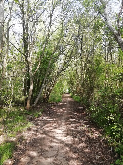
Roodee Mere is a picturesque freshwater lake located in Cheshire, England. Spanning an area of approximately 30 acres, it is a popular destination for nature enthusiasts and locals alike. The name "Roodee Mere" originates from the Old English word "rod" meaning clearing or pasture, indicating its historical use as grazing land.

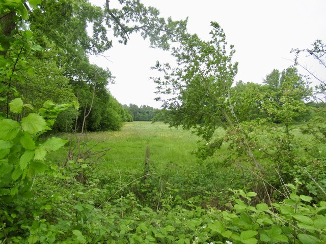
Surrounded by lush greenery, the lake is home to a diverse range of flora and fauna. It boasts a tranquil ambiance, with the soothing sounds of water lapping against the shore and the gentle rustling of leaves from the surrounding trees. The crystal-clear waters of Roodee Mere are teeming with various species of fish, attracting avid anglers who enjoy a peaceful day of fishing.

The lake also serves as a habitat for numerous bird species, making it a popular spot for birdwatchers. Visitors can observe graceful swans gliding across the water, ducks paddling in search of food, and the occasional heron stalking its prey along the shoreline. The surrounding marshland provides a haven for wetland plants and wildlife, creating a vibrant ecosystem.

Roodee Mere offers recreational activities such as boating and kayaking, allowing visitors to fully immerse themselves in the natural splendor of the lake. The scenic walking trails that encircle the lake provide an opportunity for leisurely strolls, with benches strategically placed for visitors to relax and take in the breathtaking views.

Overall, Roodee Mere is a serene and idyllic destination that showcases the beauty of Cheshire's natural landscapes. Whether it's for a peaceful retreat or an exploration of nature's wonders, this freshwater lake offers a truly unforgettable experience for all who visit.

If you have any feedback on the listing, please let us know in the comments section below.

Roodee Mere Images

Images are sourced within 2km of 53.363727/-3.1324148 or Grid Reference SJ2485. Thanks to Geograph Open Source API. All images are credited.

Track to RAF West Kirby A track through the woodland south of Saughall Massey Road at Larton. This was the site of a Second World War RAF training camp, now overgrown, the concrete road can still be seen beneath the leaf litter.
Track to RAF West Kirby
A track through the woodland south of Saughall Massey Road at Larton. This was the site of a Second World War RAF training camp, now overgrown, the concrete road can still be seen beneath the leaf litter.
Field, Irbyside
Field, Irbyside
Greasby Village Village shops, Greasby Road, Greasby.
Greasby Village
Village shops, Greasby Road, Greasby.
Red Croft Redcroft retirement apartments, Well Lane, Greasby.
Red Croft
Redcroft retirement apartments, Well Lane, Greasby.
Frankby Road Redcroft retirement apartments, Frankby Road, Greasby.
Frankby Road
Redcroft retirement apartments, Frankby Road, Greasby.
Pump Lane Round-About, Pump Lane, Well Lane, Frankby Road, Greasby.
Pump Lane
Round-About, Pump Lane, Well Lane, Frankby Road, Greasby.
One A Footpath between Frankby and Greasby Roads, to the rear of Red Cat public house, Greasby.
One A
Footpath between Frankby and Greasby Roads, to the rear of Red Cat public house, Greasby.
Red Cat Red Cat public house, Greasby Village, Greasby Road.
Red Cat
Red Cat public house, Greasby Village, Greasby Road.
Greasby Library Greasby Library and new extension. Greasby Village, Greasby Road.
Greasby Library
Greasby Library and new extension. Greasby Village, Greasby Road.
Greasby Health Centre Health Centre and chemist, Greasby Village, Frankby Road, Greasby.
Greasby Health Centre
Health Centre and chemist, Greasby Village, Frankby Road, Greasby.
Greasby Community Centre Greasby Road, Greasby.
Greasby Community Centre
Greasby Road, Greasby.
Greave Dunning Ember Inn, Greave Dunning, Greasby Road, Greasby.
Greave Dunning
Ember Inn, Greave Dunning, Greasby Road, Greasby.
Farmer's Arms Hill Bark Road, Wirral
Farmer's Arms
Hill Bark Road, Wirral
Irby Village Stocks In the gardens of Irby Library, Thurstaston Road.
Irby Village Stocks
In the gardens of Irby Library, Thurstaston Road.
Irby Library A view of Irby Village stocks to the front of Irby library.
Irby Library
A view of Irby Village stocks to the front of Irby library.
Irby Hall Built in the 17th Century, Irby Hall is on the site of an ancient manor house. Apparently some reconstruction and restoration works took place in 1888.
Irby Hall
Built in the 17th Century, Irby Hall is on the site of an ancient manor house. Apparently some reconstruction and restoration works took place in 1888.
Thurstaston Road Public footpath kissing gate leading to Thurstaston via Dawlish Road, Irby.
Thurstaston Road
Public footpath kissing gate leading to Thurstaston via Dawlish Road, Irby.
Anchor Inn Thurstaston Road, Irby.
Anchor Inn
Thurstaston Road, Irby.
Show me another place!

Roodee Mere is located at Grid Ref: SJ2485 (Lat: 53.363727, Lng: -3.1324148)

Unitary Authority: Wirral

Police Authority: Merseyside

What 3 Words

///unopposed.sobs.happier. Near Greasby, Merseyside

Related Wikis

Royden Park

Royden Park is a park in Frankby, Wirral, England, managed by Wirral Council. The grounds of the park were originally part of an estate owned by Ernest...

Hill Bark Farmhouse

Hill Bark Farmhouse is to the east of the house of Hill Bark, and south of the hamlet of Frankby, Wirral, England. It is recorded in the National Heritage...

Hill Bark

Hill Bark (also known as Bidston Court) is a large country house to the south of the hamlet of Frankby, Wirral, Merseyside, England. It is recorded in...

Paton Field

Paton Field is located on Telegraph Road, in Thurstaston, Wirral Peninsula, England. The stadium is the home of Caldy RFC. == References == == External... ==

Caldy RFC

Caldy Rugby Club is an English rugby union club which play in the RFU Championship, the second tier of English rugby, following their promotion from National...

Thurstaston Common

Thurstaston Common is an area of almost 250 acres (100 ha) of parklands, wood and heath between Frankby and Thurstaston, on the Wirral Peninsula in North...

Frankby

Frankby (locally ) is a village and former civil parish, in the Wirral district, in Merseyside, England. It is located on the Wirral Peninsula between...

Greasby

Greasby (locally ) is a large village on the Wirral Peninsula, Merseyside, England. A predominantly residential area, it is contiguous with Upton to the...

Related Videos

Pathfinder Guide Walks - Caldy Hill, Thurstaston & The Wirral Way

Join me on a 7 mile-ish bimble around Caldy Hill, Thurstaston and The Wirral way, following walk 20 from the Ordnance Survey ...

Exploring The Wirral | Walk To St Bartholomew's Church Inc Drone Flight | Beach Walk.

Day 3 Part 2 We Take You On A Beautiful Walk To St Bartholomew's Church At Thurstaston Inc A Stunning Stunning Flight And ...

Thurstaston Common visit / Thor’s Stone / Wirral, UK / #explore #walking #weekendvibes #touristplace

Thurstaston Common is a mysterious red sandstone landmark known as Thor's Rock. The rock has been the subject of much ...

Nearby Amenities

Located within 500m of 53.363727,-3.1324148
Bus Stop
HILLBARK ROAD/FERNDALE AVENUE
Bus: yes
Naptan AtcoCode: 2800S31030A
Naptan Bearing: NW
Naptan CommonName: HILLBARK ROAD/FERNDALE AVENUE
Naptan Indicator: HILLBARK ROAD
Naptan Landmark: CORNER FERNDALE AVENUE
Naptan NaptanCode: mergmdpm
Naptan Notes: No Notes
Naptan ShortCommonName: Hillbark Rd
Naptan Street: HILLBARK ROAD
Naptan Verified: no
Public Transport: platform
Source: naptan_import
Lat/Long: 53.367779/-3.1328942
Bench
Backrest: no
Inscription: In Memory of Myfriend and Master TED Diead 31 December 2007 Aged 83 years. “PRINCE”
Lat/Long: 53.3615437/-3.1346417
Bench
Lat/Long: 53.3623215/-3.1382072
Bench
Lat/Long: 53.3624837/-3.1366851
Bench
Lat/Long: 53.3628139/-3.1397224
Toilets
Check Date: 2022-11-20
Lat/Long: 53.3639018/-3.1347095
Bench
Lat/Long: 53.364061/-3.1328764
Barrier: entrance
Lat/Long: 53.364114/-3.134412
Royden Park Minature Railway
Public Transport: station
Railway: station
Usage: tourism
Lat/Long: 53.3630039/-3.1330833
Bench
Lat/Long: 53.3630187/-3.1337097
Bench
Lat/Long: 53.3628962/-3.1338973
Bench
Lat/Long: 53.3630208/-3.1334797
Bench
Lat/Long: 53.362797/-3.1336743
Bench
Lat/Long: 53.3628983/-3.1333452
Cafe
The Courtyard
Check Date: 2022-11-20
Lat/Long: 53.363874/-3.1346387
Bench
Backrest: yes
Inscription: JOYCE MCGRATH Treasured Memories
Lat/Long: 53.3628356/-3.1383283
Bench
Backrest: yes
Lat/Long: 53.365318/-3.1383151
The data included in this document is from www.openstreetmap.org. The data is made available under ODbL.

Have you been to Roodee Mere?

Leave your review of Roodee Mere below (or comments, questions and feedback).