Àird Sleitinis

Coastal Feature, Headland, Point in Ross-shire

Scotland

Àird Sleitinis

Mullach na h-Airde Bige Second HuMP around the northern edge of Loch Resort on an Alan Holmes RIB trip. What a brilliant day.
Name: Mullach na h-Airde Bige
Hill number: 4947
Height: 182m / 597ft
Area: 24A: Lewis and Nearby Islands
Class: Hu,1
Grid ref: NB026188 (est)
Drop: 128m
Col: 54m  NB044194
Mullach na h-Airde Bige Credit: Rude Health

Àird Sleitinis is a prominent coastal feature located in Ross-shire, Scotland. Situated on the western coast of the Scottish Highlands, it is a headland or point that juts out into the North Atlantic Ocean. The name "Àird Sleitinis" is of Gaelic origin and translates to "Point of Sleat."

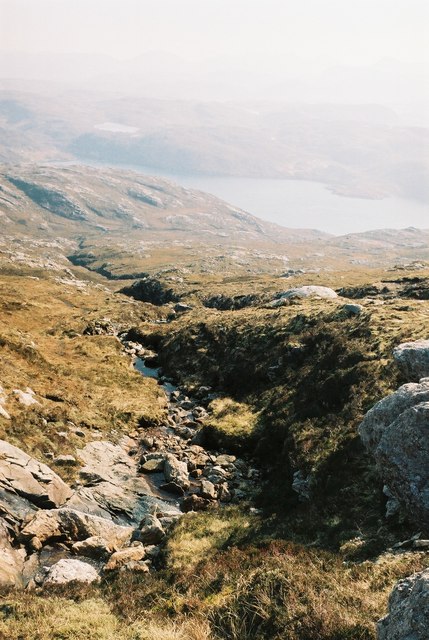
This headland is characterized by its rugged and dramatic landscape, which showcases steep cliffs that overlook the ocean. The cliffs are composed of various rock formations, including sandstone, schist, and granite, adding to the area's visual appeal.

The point offers stunning panoramic views of the surrounding seascape and is a popular spot for tourists and nature enthusiasts. Its strategic location at the edge of the Atlantic Ocean also makes it an ideal spot for observing marine wildlife. Visitors often spot various seabirds, including puffins, gannets, and guillemots, as well as seals and dolphins swimming in the waters below.

In addition to its natural beauty, Àird Sleitinis also has historical significance. It has been inhabited for centuries, and remnants of ancient settlements, including stone structures and burial sites, can be found in the vicinity. These archaeological remains provide insights into the area's rich cultural heritage.

Overall, Àird Sleitinis is a captivating coastal feature that offers a unique blend of natural beauty, wildlife, and historical significance. Its rugged cliffs, panoramic views, and diverse flora and fauna make it a must-visit destination for those exploring the Ross-shire region of Scotland.

If you have any feedback on the listing, please let us know in the comments section below.

Àird Sleitinis Images

Images are sourced within 2km of 58.066812/-7.0378836 or Grid Reference NB0319. Thanks to Geograph Open Source API. All images are credited.

Mullach na h-Airde Bige Second HuMP around the northern edge of Loch Resort on an Alan Holmes RIB trip. What a brilliant day.
Name: Mullach na h-Airde Bige
Hill number: 4947
Height: 182m / 597ft
Area: 24A: Lewis and Nearby Islands
Class: Hu,1
Grid ref: NB026188 (est)
Drop: 128m
Col: 54m  NB044194
Mullach na h-Airde Bige
Second HuMP around the northern edge of Loch Resort on an Alan Holmes RIB trip. What a brilliant day. Name: Mullach na h-Airde Bige Hill number: 4947 Height: 182m / 597ft Area: 24A: Lewis and Nearby Islands Class: Hu,1 Grid ref: NB026188 (est) Drop: 128m Col: 54m NB044194
Steep Climb From Landing Point For Mullach na h-Airde Bige Our boatman Neil was a little worried by the steep climb up from our landing point. It proved to be no problem for Douglas Law, Alan Holmes, George Morl, Michael Earnshaw, Jim Bloomer, Martin Richardson, Mark Smith, Richard Tibbetts and Colin Crawford who were soon on top of the HuMP, Mullach na h-Airde Bige.
Steep Climb From Landing Point For Mullach na h-Airde Bige
Our boatman Neil was a little worried by the steep climb up from our landing point. It proved to be no problem for Douglas Law, Alan Holmes, George Morl, Michael Earnshaw, Jim Bloomer, Martin Richardson, Mark Smith, Richard Tibbetts and Colin Crawford who were soon on top of the HuMP, Mullach na h-Airde Bige.
Eoranish More Bagged on a RIB trip with 8 others to the HuMPs north of Loch Resort. Looking west towards Mullach na h-Airde Bige.
Name: Eoranish More
Hill number: 104363
Height: 158m / 518ft
Area: 24A: Lewis and Nearby Islands
Class: 1
Grid ref: NB032188 (est)
Drop: 79m
Col: 79m
Eoranish More
Bagged on a RIB trip with 8 others to the HuMPs north of Loch Resort. Looking west towards Mullach na h-Airde Bige. Name: Eoranish More Hill number: 104363 Height: 158m / 518ft Area: 24A: Lewis and Nearby Islands Class: 1 Grid ref: NB032188 (est) Drop: 79m Col: 79m
View Across Loch Gruineabhat View across Loch Gruineabhat and beyond to the subHuMP Aineabhal which is the next hill on our bagging list today.
View Across Loch Gruineabhat
View across Loch Gruineabhat and beyond to the subHuMP Aineabhal which is the next hill on our bagging list today.
Crossing Damp Moorland Crossing damp moorland after descending from Eoranish More and heading towards Aineabhal.
Crossing Damp Moorland
Crossing damp moorland after descending from Eoranish More and heading towards Aineabhal.
Rubha Geodha nan Sgarbh The entrance to Loch Tealasvay is well concealed close to the right of the picture.
Rubha Geodha nan Sgarbh
The entrance to Loch Tealasvay is well concealed close to the right of the picture.
House and Outbuildings at Tamnabhaigh
Loch Tamnabhaigh Aird Bheag to left of image and Tamana Sear to right
Loch Tamnabhaigh
Aird Bheag to left of image and Tamana Sear to right
Loch Cheann Chuisil This sheltered loch offers anchorage during stormy weather
Loch Cheann Chuisil
This sheltered loch offers anchorage during stormy weather
Burn flowing into Gleann Sgaladail
The head of Gleann Sgaladail The lower picture shows ruined shielings with a burn running through.
The head of Gleann Sgaladail
The lower picture shows ruined shielings with a burn running through.
Ruined shielings in Gleann Sgaladail
Gleann Sgaladail burn meets Loch Tamnabhaigh
Moorland above Loch Tamnabhaigh
Mocleitean from Aird Bheag with Eilean Mhealasta in the background
Bridge over Abhainn Tamnabhaig
Mol Tealasbhaigh Even in this remote inlet on the Atlantic Western Seaboard of Harris there is much evidence of plastic litter
Mol Tealasbhaigh
Even in this remote inlet on the Atlantic Western Seaboard of Harris there is much evidence of plastic litter
Aird Bheag Number 1 Aird Bheag on the shore of Loch Hamnaway
Aird Bheag
Number 1 Aird Bheag on the shore of Loch Hamnaway
Show me another place!

Àird Sleitinis is located at Grid Ref: NB0319 (Lat: 58.066812, Lng: -7.0378836)

Unitary Authority: Na h-Eileanan an Iar

Police Authority: Highlands and Islands

What 3 Words

///unearthly.mixes.quest. Near Tarbert, Na h-Eileanan Siar

Related Wikis

Mealista

Mealista (Scottish Gaelic: Mealasta) was a township in the west of the Isle of Lewis. It is currently largely uninhabited due to the Highland Clearances...

Game pieces of the Lewis chessmen hoard

Game pieces of the Lewis chessmen hoard include the ninety-three game pieces of the Lewis chessmen hoard found on the Isle of Lewis in the Outer Hebrides...

Eilean Mhealasta

Eilean Mhealasta (Mealista Island) is an uninhabited island off the west coast of Lewis in the Outer Hebrides of Scotland. It takes its name from Mealista...

Scarp, Scotland

Scarp (Scottish Gaelic: An Sgarp) is an uninhabited island in the Outer Hebrides of Scotland, west of Hushinish on Harris. Once inhabited, the island was...

Nearby Amenities

Located within 500m of 58.066812,-7.0378836
Created By: dmgroom_coastlines
Lat/Long: 58.06539/-7.04225
Tob Cul na h-Airde
Natural: bay
Lat/Long: 58.0665327/-7.0402919
Tob Cul na h-Airde Bige
Natural: bay
Lat/Long: 58.066964/-7.035142
Loch Tamnabhaigh
Natural: bay
Lat/Long: 58.0702779/-7.0362364
Aird Sleitinis
Natural: cape
Lat/Long: 58.0670221/-7.0381429
Tatarol
Place: locality
Lat/Long: 58.0653219/-7.0328126
The data included in this document is from www.openstreetmap.org. The data is made available under ODbL.

Have you been to Àird Sleitinis?

Leave your review of Àird Sleitinis below (or comments, questions and feedback).