Mearbeck Wood

Wood, Forest in Yorkshire Craven

England

Mearbeck Wood

Holy Trinity Church, Rathmell Viewed in disappointing mid-June light, the churchyard was decorated for the Queen's Platinum Jubilee. For information about the building, see <a href="https://www.geograph.org.uk/photo/1445269">SD8059 : Holy Trinity Church, Rathmell</a>
Holy Trinity Church, Rathmell Credit: Mary and Angus Hogg

Mearbeck Wood is a picturesque woodland located in the county of Yorkshire, England. Situated near the village of Mearbeck, it covers an area of approximately 100 acres and forms part of the larger Nidderdale Area of Outstanding Natural Beauty.

The wood is predominantly composed of native tree species such as oak, birch, and beech, creating a diverse and vibrant ecosystem. Its dense canopy provides shelter and nesting sites for a variety of bird species, including woodpeckers, owls, and thrushes. The forest floor is adorned with an array of wildflowers and ferns, adding to its natural beauty.

Traversing through Mearbeck Wood, visitors can follow well-maintained footpaths that wind their way through the trees. These paths offer an opportunity to explore the woodland at a leisurely pace, immersing oneself in the tranquil surroundings. Along the way, there are several designated picnic areas where visitors can stop and enjoy a packed lunch amidst the serenity of the forest.

Mearbeck Wood is not only a haven for nature enthusiasts but also serves as an important wildlife corridor, connecting various habitats in the region. The wood plays a crucial role in supporting biodiversity and preserving the native flora and fauna of Yorkshire.

Managed by the local conservation authority, Mearbeck Wood is open to the public year-round, allowing visitors to experience the changing seasons and witness the wood's beauty in different lights. Whether it's a peaceful walk, birdwatching, or simply enjoying the serenity of nature, Mearbeck Wood offers a truly enchanting experience for all who visit.

If you have any feedback on the listing, please let us know in the comments section below.

Mearbeck Wood Images

Images are sourced within 2km of 54.043078/-2.2804921 or Grid Reference SD8160. Thanks to Geograph Open Source API. All images are credited.
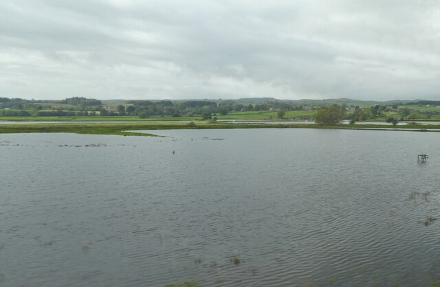
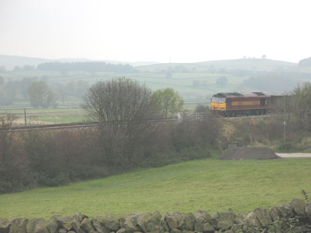
Holy Trinity Church, Rathmell Viewed in disappointing mid-June light, the churchyard was decorated for the Queen's Platinum Jubilee. For information about the building, see <a href="https://www.geograph.org.uk/photo/1445269">SD8059 : Holy Trinity Church, Rathmell</a>
Holy Trinity Church, Rathmell
Viewed in disappointing mid-June light, the churchyard was decorated for the Queen's Platinum Jubilee. For information about the building, see SD8059 : Holy Trinity Church, Rathmell
Rathmell Reading Room In the heart of Rathmell village, decorated for the Platinum Jubilee. The building is located at the junction of Hesley Lane and Main Street.
Rathmell Reading Room
In the heart of Rathmell village, decorated for the Platinum Jubilee. The building is located at the junction of Hesley Lane and Main Street.
Old milestone Another of the original 37 milestones set up on this route in 1893/94 for the West Riding CC.   It is looking very sad in its rusty coat.  There is no foundry name on the bevel but it could have been made by William Towler at the Globe Foundry in Leeds as were several milestones on this road.
Old milestone
Another of the original 37 milestones set up on this route in 1893/94 for the West Riding CC. It is looking very sad in its rusty coat. There is no foundry name on the bevel but it could have been made by William Towler at the Globe Foundry in Leeds as were several milestones on this road.
Old milestone Travelling towards Settle near Skir Beck, the thickness of the backing stone on these West Riding CC milestones can be appreciated.   615 were set up all over the old West Riding in 12 months from 1893/94.  It is Grade II listed 1301418.
Old milestone
Travelling towards Settle near Skir Beck, the thickness of the backing stone on these West Riding CC milestones can be appreciated. 615 were set up all over the old West Riding in 12 months from 1893/94. It is Grade II listed 1301418.
Flooded fields in Ribblesdale
Rathmell Reading Room, Rathmell village Rathmell Young Farmers Club uses the reading room weekly on Tuesdays at 7:30pm.
Rathmell Reading Room, Rathmell village
Rathmell Young Farmers Club uses the reading room weekly on Tuesdays at 7:30pm.
The Road to The Riddings Going over the tatty cattle grid is hairy enough, trying to turn right on to the A65 was even worse.
The Road to The Riddings
Going over the tatty cattle grid is hairy enough, trying to turn right on to the A65 was even worse.
High Barn An out barn between Edge Lane and The Riddings
High Barn
An out barn between Edge Lane and The Riddings
Railway at Skir Beck A southbound gypsum train crosses the farm access bridge at Skir Beck.
Railway at Skir Beck
A southbound gypsum train crosses the farm access bridge at Skir Beck.
River Ribble This land is managed by local farmers and lots of environment organisations as the area is of great importance to wildlife and geological studies
River Ribble
This land is managed by local farmers and lots of environment organisations as the area is of great importance to wildlife and geological studies
Railway Bridge near Long Preston Old farmhouse just off the A65
Railway Bridge near Long Preston
Old farmhouse just off the A65
Long Preston Bigholmes Lane
Long Preston
Bigholmes Lane
Holy Trinity Church, Rathmell Built in 1842, with stained glass of 1870 by Capronnier in two windows. The font, with slender stem and a domed cover, is in the base of the tower, which is only 2.1m square internally.  Information from Arthur Mee  (King's England) and Nikolaus Pevsner (The Buildings of England).
Holy Trinity Church, Rathmell
Built in 1842, with stained glass of 1870 by Capronnier in two windows. The font, with slender stem and a domed cover, is in the base of the tower, which is only 2.1m square internally. Information from Arthur Mee (King's England) and Nikolaus Pevsner (The Buildings of England).
The village street, Rathmell The reading room is on the left, and the war memorial in silhouette. On the right, the signpost still has its top of the standard West Riding type, with civil parish name and six-figure grid reference.
The village street, Rathmell
The reading room is on the left, and the war memorial in silhouette. On the right, the signpost still has its top of the standard West Riding type, with civil parish name and six-figure grid reference.
Pastures beside Edge Lane High Barn perched on the drop-off into the Ribble Valley.
Pastures beside Edge Lane
High Barn perched on the drop-off into the Ribble Valley.
Meanders in Ribblesdale The River Ribble running from north [left] to south [right]. The crescent remains of an oxbow, the remains of a former meander, are visible near where the river approaches the road and railway. The Skipton-Hellifield road [A65] and railway share the valley. The settlements to left and right are Rathmell and Wigglesworth.
Meanders in Ribblesdale
The River Ribble running from north [left] to south [right]. The crescent remains of an oxbow, the remains of a former meander, are visible near where the river approaches the road and railway. The Skipton-Hellifield road [A65] and railway share the valley. The settlements to left and right are Rathmell and Wigglesworth.
Track leaving Edge Lane
Show me another place!

Mearbeck Wood is located at Grid Ref: SD8160 (Lat: 54.043078, Lng: -2.2804921)

Division: West Riding

Administrative County: North Yorkshire

District: Craven

Police Authority: North Yorkshire

What 3 Words

///surfer.sedative.user. Near Settle, North Yorkshire

Nearby Locations

Mearbeck Wood Mearbeck

Related Wikis

Settle Junction railway station

Settle Junction railway station was located near the town of Settle, North Yorkshire, England, immediately to south of the junction between the Midland...

Rathmell

Rathmell is a village and civil parish in the Craven district of North Yorkshire, England. The population of the civil parish in the 2011 census was 305...

Giggleswick railway station

Giggleswick is a railway station on the Bentham Line, which runs between Leeds and Morecambe via Skipton. The station, situated 41+1⁄4 miles (66 km) north...

Settle railway station

Settle is a railway station on the Settle and Carlisle Line, which runs between Carlisle and Leeds via Settle. The station, situated 41 miles 37 chains...

Nearby Amenities

Located within 500m of 54.043078,-2.2804921
Cleatop Park
Natural: woodland
Source: OS OpenData StreetView
Lat/Long: 54.0463185/-2.2769546
Mearbeck Wood
Natural: woodland
Source: OS OpenData StreetView
Lat/Long: 54.0429546/-2.2807312
Cleatop Wood
Natural: woodland
Source: OS OpenData StreetView
Lat/Long: 54.0463689/-2.2822761
Power: pole
Source: Bing
Lat/Long: 54.0393685/-2.276788
Power: pole
Source: Bing
Lat/Long: 54.0399341/-2.2769634
Power: pole
Source: Bing
Transformer: distribution
Lat/Long: 54.0402135/-2.2782982
Power: pole
Source: Bing
Lat/Long: 54.0404886/-2.277185
Power: pole
Source: Bing
Lat/Long: 54.0411802/-2.2772222
Power: pole
Source: Bing
Lat/Long: 54.0423647/-2.2880083
Power: pole
Source: Bing
Lat/Long: 54.0431747/-2.2880947
Power: pole
Source: Bing
Lat/Long: 54.0432408/-2.2791075
Power: pole
Source: Bing
Lat/Long: 54.0462943/-2.2800551
Power: pole
Source: Bing
Lat/Long: 54.0469267/-2.2802549
Power: pole
Source: Bing
Lat/Long: 54.0474982/-2.28044
Mearbeck
Is In Municipality: Craven
Place: hamlet
Lat/Long: 54.0409739/-2.2781562
Power: pole
Lat/Long: 54.0427343/-2.278721
Power: pole
Lat/Long: 54.0456116/-2.2798614
Power: pole
Lat/Long: 54.0463076/-2.2800391
Power: pole
Lat/Long: 54.0469282/-2.2802382
Power: pole
Lat/Long: 54.0475037/-2.2804342
Power: pole
Lat/Long: 54.0437523/-2.2792701
Barrier: stile
Lat/Long: 54.0390038/-2.2777681
Barrier: yes
Lat/Long: 54.0396883/-2.2777931
Description: South:"Public Footpath Long Preston 2 1/2 ML"; East:"Public Footpath Settle 2 ML"
Information: guidepost
Tourism: information
Lat/Long: 54.0405034/-2.2794825
Barrier: stile
Lat/Long: 54.045363/-2.2824939
Barrier: stile
Lat/Long: 54.0437188/-2.2815187
Barrier: stile
Lat/Long: 54.0428364/-2.2830851
Banks Crag
Place: locality
Source: OS sheet 132, publ 1851
Lat/Long: 54.0407954/-2.2755054
Power: pole
Lat/Long: 54.0420747/-2.2783059
Power: pole
Transformer: distribution
Lat/Long: 54.0416621/-2.2780202
Power: pole
Source: Bing
Lat/Long: 54.0441772/-2.2794052
Power: pole
Source: Bing
Lat/Long: 54.0448613/-2.2796228
The data included in this document is from www.openstreetmap.org. The data is made available under ODbL.

Have you been to Mearbeck Wood?

Leave your review of Mearbeck Wood below (or comments, questions and feedback).