Brickyard Covert

Wood, Forest in Shropshire

England

Brickyard Covert

In the cutting near Cheswardine Road Bridge The canal here, just south of the cutting, starts to widen again. Daft Dog is wondering if he's allowed a swim (no, is the answer.)
In the cutting near Cheswardine Road Bridge Credit: Richard Law

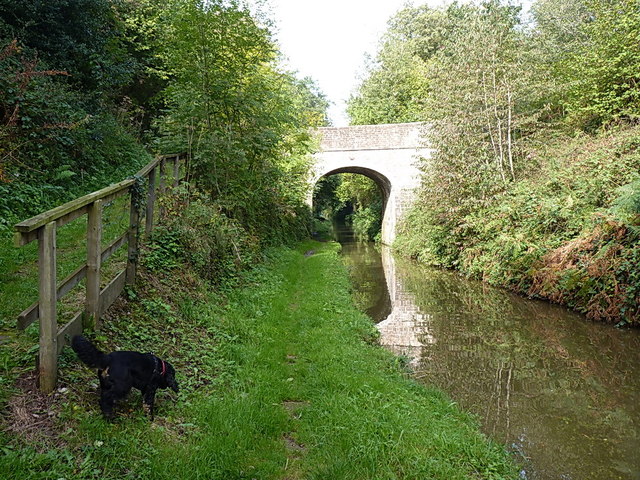
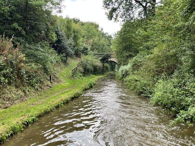
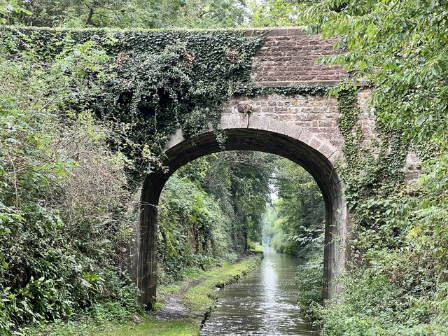
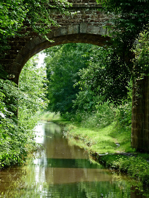
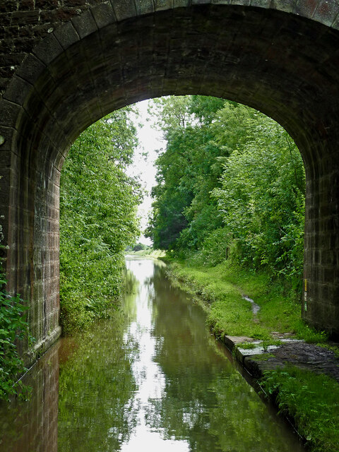
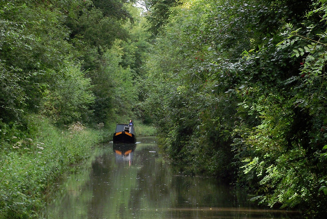
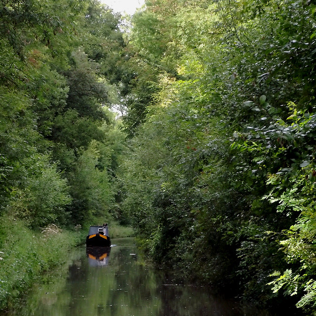
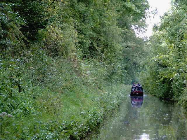
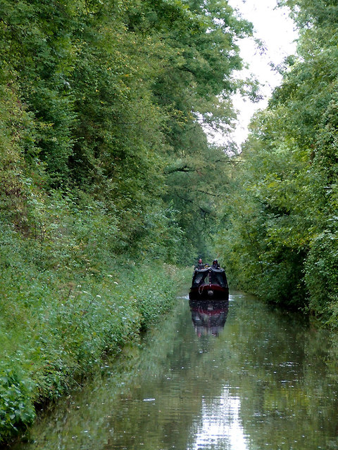
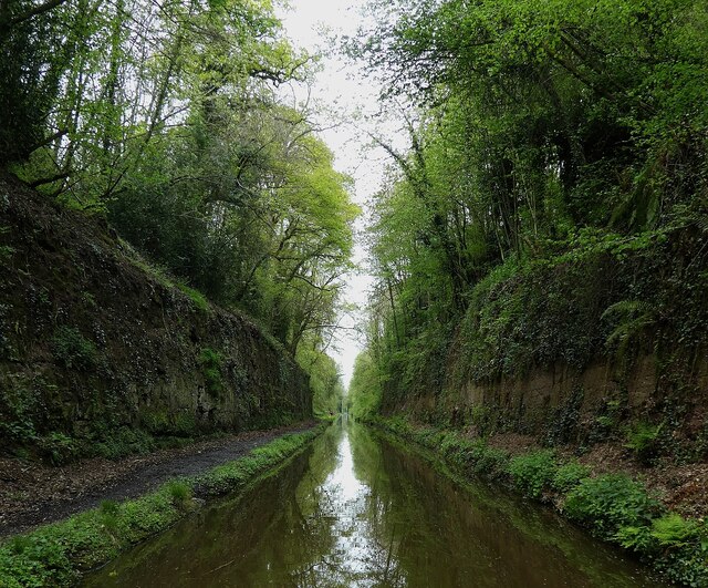
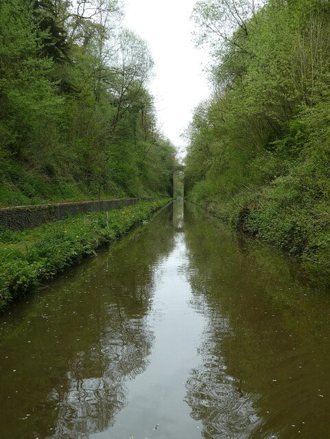
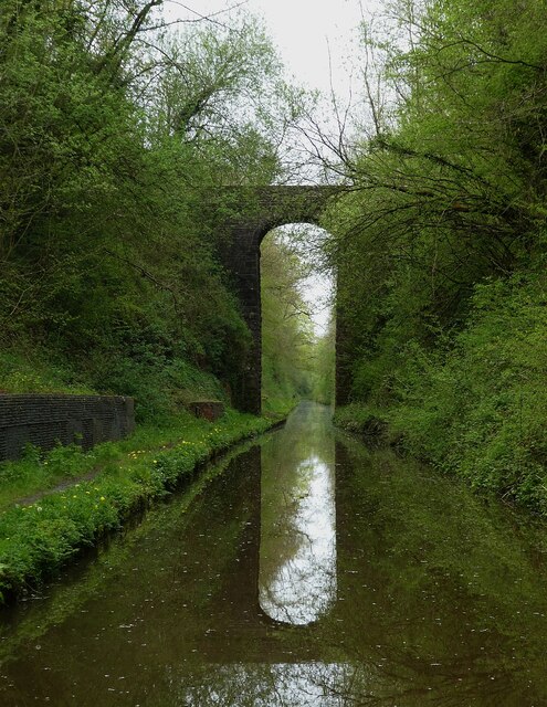
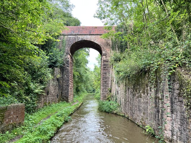
Brickyard Covert is a picturesque woodland located in Shropshire, England. Spread across an area of approximately 20 acres, this tranquil forest is nestled in the heart of the county, attracting nature lovers and outdoor enthusiasts alike.

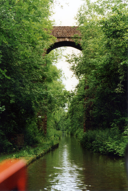
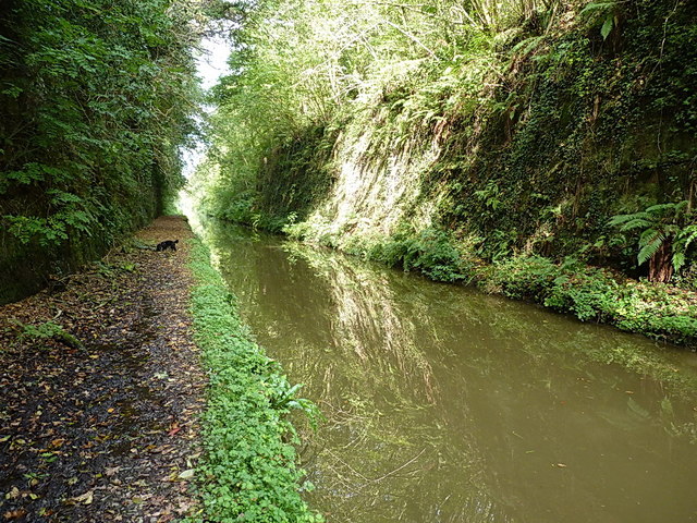
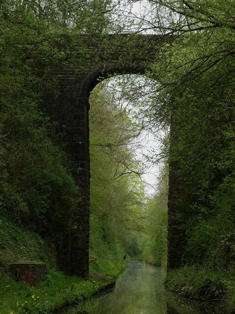
The woodland is characterized by its dense canopy of trees, predominantly consisting of oak, ash, and beech, which create a serene and shaded environment. The forest floor is covered with a diverse range of flora, including bluebells, wild garlic, and ferns, adding to the enchanting ambiance.

Brickyard Covert is home to a variety of wildlife species. Visitors may spot deer roaming among the trees, rabbits darting through the undergrowth, and a plethora of bird species, such as woodpeckers and songbirds. The woodland is also known for its rich insect population, including butterflies and dragonflies, making it a haven for nature enthusiasts and photographers.

The forest offers several walking trails, allowing visitors to explore its beauty at their own pace. These trails meander through the woods, offering glimpses of a picturesque stream that runs through the heart of Brickyard Covert. Along the way, visitors can take advantage of strategically placed benches to rest and enjoy the peaceful surroundings.

Brickyard Covert is managed by local conservation organizations, ensuring its preservation and protection for future generations. The woodland is open to the public throughout the year, with no admission fee. It serves as an idyllic escape from the hustle and bustle of everyday life, providing a serene and natural retreat for all who visit.

If you have any feedback on the listing, please let us know in the comments section below.

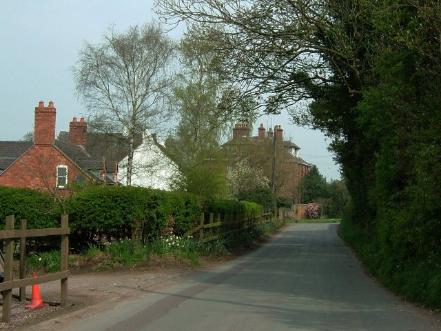
Brickyard Covert Images

Images are sourced within 2km of 52.87789/-2.4255216 or Grid Reference SJ7131. Thanks to Geograph Open Source API. All images are credited.

In the cutting near Cheswardine Road Bridge The canal here, just south of the cutting, starts to widen again. Daft Dog is wondering if he's allowed a swim (no, is the answer.)
In the cutting near Cheswardine Road Bridge
The canal here, just south of the cutting, starts to widen again. Daft Dog is wondering if he's allowed a swim (no, is the answer.)
Cheswardine Road Bridge The start of the narrow Woodseaves cutting, which heads up towards Tyrley Locks on the outskirts of Market Drayton.
Cheswardine Road Bridge
The start of the narrow Woodseaves cutting, which heads up towards Tyrley Locks on the outskirts of Market Drayton.
Towards Cheswarding Bridge On the Shropshire Union Canal.
Towards Cheswarding Bridge
On the Shropshire Union Canal.
Cheswardine Road Bridge Grade II listed. Listing number 1308054. Canal bridge. Circa 1830. Thomas Telford and Alexander Easton, engineers. Dressed red sandstone with tooled ashlar dressings. Elliptical arch with voussoirs and raised keystone. Flat string course, and parapet with square end piers and rounded coping. Slightly battered and curved abutments. Oval cast-iron number plate.
Cheswardine Road Bridge
Grade II listed. Listing number 1308054. Canal bridge. Circa 1830. Thomas Telford and Alexander Easton, engineers. Dressed red sandstone with tooled ashlar dressings. Elliptical arch with voussoirs and raised keystone. Flat string course, and parapet with square end piers and rounded coping. Slightly battered and curved abutments. Oval cast-iron number plate.
Canal at Cheswardine Bridge in Shropshire This is the Shropshire Union Canal at Cheswardine Bridge (No 56), and looking south-east towards Norbury and Gnosall. The canal is narrow and shallow. The towpath can be very muddy. Speeds rarely exceed 2mph, and are often less, with careful steering required when passing a narrowboat going in the opposite direction.
Canal at Cheswardine Bridge in Shropshire
This is the Shropshire Union Canal at Cheswardine Bridge (No 56), and looking south-east towards Norbury and Gnosall. The canal is narrow and shallow. The towpath can be very muddy. Speeds rarely exceed 2mph, and are often less, with careful steering required when passing a narrowboat going in the opposite direction.
Woodseaves Cutting at Cheswardine Bridge, Shropshire This is the Shropshire Union Canal at Cheswardine Road Bridge (No 56), and looking south-east towards Norbury and Gnosall. The canal is narrow and shallow. The towpath can be very muddy. Speeds rarely exceed 2mph, and are often less, with careful steering required when passing a narrowboat going in the opposite direction.
Woodseaves Cutting at Cheswardine Bridge, Shropshire
This is the Shropshire Union Canal at Cheswardine Road Bridge (No 56), and looking south-east towards Norbury and Gnosall. The canal is narrow and shallow. The towpath can be very muddy. Speeds rarely exceed 2mph, and are often less, with careful steering required when passing a narrowboat going in the opposite direction.
The canal in Woodseaves Cutting, Shropshire Shropshire Union Canal.
Woodseaves cutting, south-east of Market Drayton, is deep and so narrow that in some places boats are unable to pass by each other. It is heavily shaded by mature deciduous trees.
The canal in Woodseaves Cutting, Shropshire
Shropshire Union Canal. Woodseaves cutting, south-east of Market Drayton, is deep and so narrow that in some places boats are unable to pass by each other. It is heavily shaded by mature deciduous trees.
The canal in Woodseaves Cutting, Shropshire Shropshire Union Canal.
Woodseaves cutting, south-east of Market Drayton, is deep and so narrow that in some places boats are unable to pass by each other. Progress can be slow. It is heavily shaded by mature deciduous trees.
The canal in Woodseaves Cutting, Shropshire
Shropshire Union Canal. Woodseaves cutting, south-east of Market Drayton, is deep and so narrow that in some places boats are unable to pass by each other. Progress can be slow. It is heavily shaded by mature deciduous trees.
Woodseaves Cutting north of High Bridge, Shropshire Shropshire Union Canal
Woodseaves Cutting (which has its resident ghost!) is the longest cutting on any canal in Britain. The sides are steep and there have been many slips, blocking the canal. Early canals tended to keep earthworks to a minimum by winding round hills, whereas later canals such as this one tended to have more direct routes, with deeper cuttings and higher embankments.

Note: this is NOT near the village of Woodseaves (by High Offley) to the south-west.
Woodseaves Cutting north of High Bridge, Shropshire
Shropshire Union Canal Woodseaves Cutting (which has its resident ghost!) is the longest cutting on any canal in Britain. The sides are steep and there have been many slips, blocking the canal. Early canals tended to keep earthworks to a minimum by winding round hills, whereas later canals such as this one tended to have more direct routes, with deeper cuttings and higher embankments. Note: this is NOT near the village of Woodseaves (by High Offley) to the south-west.
Woodseaves Cutting north of High Bridge, Shropshire Shropshire Union Canal.
Woodseaves Cutting (which has its resident ghost!) is the longest cutting on any canal in Britain. The sides are steep and there have been many slips, blocking the canal. Early canals tended to keep earthworks to a minimum by winding round hills, whereas later canals such as this one tended to have more direct routes, with deeper cuttings and higher embankments.
Woodseaves Cutting north of High Bridge, Shropshire
Shropshire Union Canal. Woodseaves Cutting (which has its resident ghost!) is the longest cutting on any canal in Britain. The sides are steep and there have been many slips, blocking the canal. Early canals tended to keep earthworks to a minimum by winding round hills, whereas later canals such as this one tended to have more direct routes, with deeper cuttings and higher embankments.
High Bridge 57 Shropshire Union Canal The Shropshire Union Canal (from Autherley to Nantwich) was engineered by Thomas Telford and opened in 1835. There are long straight sections of this canal which required either embankments or cuttings to avoid the need for locks. Although this was a more difficult procedure, the end route was shorter and the progress for horse drawn working boats could be maintained with (hopefully) no stoppages. The canal (formerly the Birmingham and Liverpool Junction Canal) was opened at a time when railways were making serious inroads into the canal companies' businesses. 

The current Shroppie north of Nantwich was formerly the Chester Canal, opened in 1779, and has wider locks and bridges. Boats up to nine feet in beam can still navigate this section; Telford's canal accommodates only narrowboats up to seven feet in beam.
High Bridge 57 Shropshire Union Canal
The Shropshire Union Canal (from Autherley to Nantwich) was engineered by Thomas Telford and opened in 1835. There are long straight sections of this canal which required either embankments or cuttings to avoid the need for locks. Although this was a more difficult procedure, the end route was shorter and the progress for horse drawn working boats could be maintained with (hopefully) no stoppages. The canal (formerly the Birmingham and Liverpool Junction Canal) was opened at a time when railways were making serious inroads into the canal companies' businesses. The current Shroppie north of Nantwich was formerly the Chester Canal, opened in 1779, and has wider locks and bridges. Boats up to nine feet in beam can still navigate this section; Telford's canal accommodates only narrowboats up to seven feet in beam.
Woodseaves Cutting The long, straight, deep and narrow cutting carries the Shroppy through a low hill between Woodseaves and Chipnall.
Woodseaves Cutting
The long, straight, deep and narrow cutting carries the Shroppy through a low hill between Woodseaves and Chipnall.
Shropshire Union Canal - High Bridge (No.57) from the south This very lofty bridge is No.57 on the Shropshire Union Canal. Not too surprisingly it is called High Bridge (a name it shares with the somewat less tall Bridge No.39 -see <a href="https://www.geograph.org.uk/photo/7167392">SJ7824 : Shropshire Union Canal - High Bridge (No.39) from the south</a>).
This is the middle of three bridges which span the Woodseaves Cutting a few miles south of Market Drayton. It is an 'accommodation bridge' and carries a minor track across the canal.
Note that this 'Woodseaves' is close to the canal to the west at this point and should not be confused with another 'Woodseaves' several miles to the southeast.
The bridge is EH Grade II listed <span class="nowrap"><a title="https://historicengland.org.uk/listing/the-list/list-entry/1293703?section=official-list-entry" rel="nofollow ugc noopener" href="https://historicengland.org.uk/listing/the-list/list-entry/1293703?section=official-list-entry">Link</a><img style="margin-left:2px;" alt="External link" title="External link - shift click to open in new window" src="https://s1.geograph.org.uk/img/external.png" width="10" height="10"/></span>
See also
<a href="https://www.geograph.org.uk/photo/7167472">SJ6930 : Shropshire Union Canal - Woodseaves Cutting - High Bridge</a>
<a href="https://www.geograph.org.uk/photo/7167474">SJ6930 : Shropshire Union Canal - Reflected High Bridge (No.57)</a>
Shropshire Union Canal - High Bridge (No.57) from the south
This very lofty bridge is No.57 on the Shropshire Union Canal. Not too surprisingly it is called High Bridge (a name it shares with the somewat less tall Bridge No.39 -see SJ7824 : Shropshire Union Canal - High Bridge (No.39) from the south). This is the middle of three bridges which span the Woodseaves Cutting a few miles south of Market Drayton. It is an 'accommodation bridge' and carries a minor track across the canal. Note that this 'Woodseaves' is close to the canal to the west at this point and should not be confused with another 'Woodseaves' several miles to the southeast. The bridge is EH Grade II listed LinkExternal link See also SJ6930 : Shropshire Union Canal - Woodseaves Cutting - High Bridge SJ6930 : Shropshire Union Canal - Reflected High Bridge (No.57)
Shropshire Union Canal - Woodseaves Cutting Woodseaves Cutting on the Shropshire Union Canal south of Market Drayton is a little over 1½ miles long and as much as 20m (66') deep. Most of it is cut through solid rock as can be seen here.
Shropshire Union Canal - Woodseaves Cutting
Woodseaves Cutting on the Shropshire Union Canal south of Market Drayton is a little over 1½ miles long and as much as 20m (66') deep. Most of it is cut through solid rock as can be seen here.
Shropshire Union Canal - Collapsed cutting Part of Woodseaves Cutting has collapsed here and a large stone has tumbled down to block the towpath. This stretch of the cutting has earth and vegetation sides whereas much of it is hewn through solid rock.
Shropshire Union Canal - Collapsed cutting
Part of Woodseaves Cutting has collapsed here and a large stone has tumbled down to block the towpath. This stretch of the cutting has earth and vegetation sides whereas much of it is hewn through solid rock.
Shropshire Union Canal - Woodseaves Cutting - High Bridge Heading along Woodseaves Cutting on the Shropshire Union Canal with High Bridge ahead.
See also
<a href="https://www.geograph.org.uk/photo/7167402">SJ6930 : Shropshire Union Canal - High Bridge (No.57) from the south</a>
<a href="https://www.geograph.org.uk/photo/7167474">SJ6930 : Shropshire Union Canal - Reflected High Bridge (No.57)</a>
Shropshire Union Canal - Woodseaves Cutting - High Bridge
Heading along Woodseaves Cutting on the Shropshire Union Canal with High Bridge ahead. See also SJ6930 : Shropshire Union Canal - High Bridge (No.57) from the south SJ6930 : Shropshire Union Canal - Reflected High Bridge (No.57)
Shropshire Union Canal - Reflected High Bridge (No.57) High Bridge (No.57) reflected in the Shropshire Union Canal, as seen when approaching it from the south. This bridge spans the Woodseaves Cutting. This very lofty bridge is an 'accommodation bridge' carrying nothing more than a minor track over the canal.
The bridge is EH Grade II listed <span class="nowrap"><a title="https://historicengland.org.uk/listing/the-list/list-entry/1293703?section=official-list-entry" rel="nofollow ugc noopener" href="https://historicengland.org.uk/listing/the-list/list-entry/1293703?section=official-list-entry">Link</a><img style="margin-left:2px;" alt="External link" title="External link - shift click to open in new window" src="https://s1.geograph.org.uk/img/external.png" width="10" height="10"/></span>
For a closer view of the bridge see <a href="https://www.geograph.org.uk/photo/7167402">SJ6930 : Shropshire Union Canal - High Bridge (No.57) from the south</a>
and for a more distant one, see <a href="https://www.geograph.org.uk/photo/7167472">SJ6930 : Shropshire Union Canal - Woodseaves Cutting - High Bridge</a>
Shropshire Union Canal - Reflected High Bridge (No.57)
High Bridge (No.57) reflected in the Shropshire Union Canal, as seen when approaching it from the south. This bridge spans the Woodseaves Cutting. This very lofty bridge is an 'accommodation bridge' carrying nothing more than a minor track over the canal. The bridge is EH Grade II listed LinkExternal link For a closer view of the bridge see SJ6930 : Shropshire Union Canal - High Bridge (No.57) from the south and for a more distant one, see SJ6930 : Shropshire Union Canal - Woodseaves Cutting - High Bridge
High Bridge Grade II listed. Listing number 1293703. Canal bridge. Circa 1830. Thomas Telford and Alexander Easton, engineers. Dressed red sandstone with rock-faced and tooled ashlar dressings. Very tall elliptical arch with voussoirs, and raised impost blocks and keystone. Flat string course, and parapet with square end piers and rounded coping. Slightly battered and curved abutments. The bridge spans the canal within a deep cutting.
High Bridge
Grade II listed. Listing number 1293703. Canal bridge. Circa 1830. Thomas Telford and Alexander Easton, engineers. Dressed red sandstone with rock-faced and tooled ashlar dressings. Very tall elliptical arch with voussoirs, and raised impost blocks and keystone. Flat string course, and parapet with square end piers and rounded coping. Slightly battered and curved abutments. The bridge spans the canal within a deep cutting.
Show me another place!

Brickyard Covert is located at Grid Ref: SJ7131 (Lat: 52.87789, Lng: -2.4255216)

Unitary Authority: Shropshire

Police Authority: West Mercia

What 3 Words

///longer.broached.vast. Near Market Drayton, Shropshire

Related Wikis

Cheswardine

Cheswardine ( CHEZ-war-dyne) is a rural village and civil parish in north east Shropshire, England. The village lies close to the border with Staffordshire...

Tyrley Canal Cutting

Tyrley Canal Cutting is a Site of Special Scientific Interest located on the Shropshire Union Canal approximately 2.5 miles south of Market Drayton, to...

Almington

Almington is a small village in Staffordshire, England. It is about 2 miles (3.2 km) east-northeast of Market Drayton by road, to the northwest of the...

Soudley, Shropshire

Soudley is a small village in Shropshire in the civil parish of Cheswardine. The village had a pub called The Wheatsheaf until it was destroyed by fire...

Have you been to Brickyard Covert?

Leave your review of Brickyard Covert below (or comments, questions and feedback).